Wednesday, February 22, 2012

Trip Report: Mt. Princeton

Mt. Princeton (14,197')
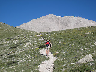
miles hiked: 13.4
Mount Princeton
On the way to Princeton
elevation gained: 5,234 feet

So we're on the summit of Mt. Princeton and a Search and Rescue helicopter is circling the skies above us, looking for a fallen climber....

Our day climbing Mt. Princeton, Prince of the Sawatch, began with dark omens. We spent the night huddled in our tent as  rain played our tent like a drum. Loud enough, even, to drown the pops and crashes of Buena Vista's Independence Day firework celebration. We lay hoping that the seams of our tent and the various, pre-departure treatments of Camp Dry would hold.

We set an early alarm, 4:30 am, since Princeton, with 6,000' of topographical prominence from Buena Vista, is one of the longest and most-strenuous climbs in all the Sawatch Range. Needless to say when we brought ourselves from the tent neither of us had had a worthy night's sleep. The air was crisp and the nearby mountains were frosted with a light coat of fresh, July snow. All the signs seemed to point towards a poor day for a climb. But the skies had cleared, and though we both struggled with the 4 am witching-hour blues, we had motivation enough to make our way to Princeton's popular trailhead even as the first rays of the morning sun crept above the eastern horizon.

Trailhead: Princeton's trailhead is a lowly 8,900', leaving almost 5,300 vertical feet for us to ascend. We'd hoped to abridge this grueling approach by driving up the Mt. Princeton Road (which serves as the first part of the trail) to a set of radio towers located at 10,800'. Gerry Roach's guidebook, Colorado's Fourteeners (the bible of Colorado fourteenering), offered this sage advice on this trailhead/approach: "There is a large parking lot at the bottom of the Mt. Princeton Road at 8,900'. If you value your vehicle, park here; this is the trailhead". We'd harbored a sincere hope that this advice was perhaps a bit outdated and overzealous, but once we reached this parking lot we discovered a large amount of cars and trucks, many with higher clearance than our humble Subaru, already parked, so we brought our car to a halt alongside them, tightened our bootstraps, and began the long, long, ascent. (We would later discover that most of these cars were not parked here by climbers but by attendees of a nearby dude ranch).

The beginning of the Mt. Princeton Rd. and our trailhead
The bummer of this base-assault technique on Princeton is that the approach becomes a 4.5 mile slog up a moderately busy 4WD road. Road approaches on mountains have never been my favorite. Four-wheelers, dirt bikes, and Jeeps kicking up choking clouds of dust makes for a mood-killing morning.
As we hiked up this relentless road we were passed by many climbers (cheaters) blasting with their trucks and SUVs up the side of the mountain. I came to look upon these people with contempt, claiming to myself that we were here to climb the mountain, not drive up it. It is more likely, however, that I was merely envious of the several miles of tough hiking that they were spared.

Route to Princeton
The road-approach to Princeton
At 11,800' "Tigger Peak" (a 13,300' companion peak of Princeton's) loomed above us, and the route steered away from the long road at last. No more cars, trucks, or "cheaters". Only a switchback or two later, mighty Princeton appeared on the horizon. It was clear from this first vantage that Princeton truly is a monarch and a powerful peak.

Not much farther, at 12,300', the rest of the route opened before us. Though it did not look far, it was a deceptively long, arduous climb to the top.

Trail to Princeton
Mt. Princeton in view at last
The last mile and a half required careful, tedious route-finding through large boulders and loose talus. Concentration was mandatory with each step to avoid a slip. Above 13,000' the route became very steep and the boot-worn trail was analogous to a precipitous slip-and-slide of gravel ball-bearings. I often found myself frequently employing all four limbs for greater purchase.

Starting to feel the benefits of having climbed nine mountains already this summer, however, we caught and eventually surpassed most of the climbers that had driven past us earlier that morning.

The last section of Mount Princeton
Mt. Princeton from around 13,000 feet
Four and a half grueling hours after leaving the car behind at the trailhead, we were on Princeton's dramatic summit sharing congratulations with other climbers. One climber loudly claimed Princeton as his "21st fourteener". He added to this voluminous boasting his opinion that "all the mountains looked the same". The Prince was my 14th fourteener, and I couldn't disagree more. I found myself resenting his brand of high-alpine cynicism. Each mountain to me is as unique as the climbers who climb them. He refused to smile when we took his summit photo for him.

View northwest from the summit of Mt. Princeton
View to the northwest from the top
(Mt. Harvard on the right in the distance, Mt. Yale in the center)
So back to the Search and Rescue helicopter...

Word reached the summit, passed along the climbing chain, that somebody had fallen on the mountain. Almost as soon as we heard this disturbing news, a bright-orange Search and Rescue helicopter appeared and proceeded to circle the mountain for most of the remaining day. We could see the entire difficult portion of the climb from the top, and nobody appeared to be injured or in distress of any sort. As we descended we ascertained from other climbers still on their way to the top that a woman was claiming that her daughter had fallen. With understandable panic (had this actually been the case) she had summoned Search and Rescue to the mountain she thought she was climbing: Mt. Princeton. Unfortunately for everyone involved, she had made a major miscalculation and had actually been climbing "Tigger Peak" (Princeton's aforementioned companion mountain).
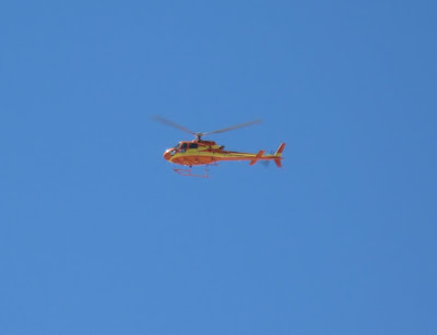
Rescue Helicopter on Mt. Princeton
The Rescue chopper dizzily circling overhead
By the time we reached the bottom we had learned the full story: in the process of ascending the wrong peak, mother and daughter had somehow become separated. Panicked, the mother had summoned Search and Rescue. Nobody had ever fallen. Nobody had ever been hurt.

My conclusion from this strange event was that many people climb 14ers who do not take these mountains seriously enough. First of all, nobody should climb a 14er if they haven't done enough research to avoid ending up on the wrong mountain. Proper studying of topo maps and the numerous available guidebooks would have made such a miscalculation almost impossible. Secondly, Search and Rescue should not have been summoned unless there had been, without a doubt, an accident. Ambulances, Sheriffs, a helicopter, and a Chaffee County Search and Rescue team a half-dozen members strong spent the better part of a day searching for a climber who was never in trouble in the first place. These hard-working folk might have had an actual emergency to attend to. This false rescue was a clear waste of resources. Though I was glad, of course, that nobody was injured, I was secretly satisfied with the knowledge that the mother-who-cried-wolf was likely stuck with a $10,000 bill for her mistake.

Visit THE ARCHIVE: A list of most of our articles sorted by department

find us on facebook

Copyright notice: This website and all its contents are the intellectual property of www.coloradomountaineering.com and its authors. None of the content can be used or reproduced without the approval of www.coloradomountaineering.com.

Climbing and mountaineering are dangerous!! Please see the DISCLAIMER page
For information about how to contact us, visit this link


Wednesday, February 8, 2012

Missouri Mountain: A Sawatch Anomaly

Missouri Mountain (14,067')

Miles hiked: 10.8
Elevation gained: 4,824 feet

5:00 comes early. Rising like Lazarus from the dead of sleep to a cold, high-alpine morning is tough to get used to, no matter how often we do it.

Missouri Mountain is a Sawatch Range anomaly. In a range dominated by mountains that, though undeniably massive, amount to little more than gently sloped mounds of grassy fields and scree, Missouri Mountain is a rugged crag and a surprisingly challenging climb. It is even challenging to determine which of the many points on Missouri's jagged ridge is the actual summit.

The Missouri Gulch trailhead, our launching pad, was very close to our basecamp, so after a quick breakfast we arrived just after 5:30 am. We strapped on our boots, yawned a good half-million times, and set out up the beautiful trail towards Missouri Gulch.

The trail starts off right away climbing steeply up a series of switchbacks through a lush growth of trees. After only a few switchbacks, we were passed by a man running up the trail! People of all sorts, unimpressive and impressive, climb fourteeners.

An hour into the climb we came upon a tent city and a rather large group of people who were camped just below treeline. This gave us the idea that when we returned to the basin to climb Belford/Oxford in two more days we could backpack to here to lessen the length and elevation of that notoriously long climb.

The next portion of the route took us through a long, broad meadow at the top of Missouri Gulch. Missouri Mountain appeared on the horizon and seemed to rise tectonically as we crested the hill on approach. We tiptoed back and forth across Missouri Gulch Creek as the jagged bastions of Missouri's north face grew before us.
Missouri's impressive north face:

Looking back on the Missouri Gulch Basin:


Ella (faint in center) in beautiful Missouri Gulch:

At 12,700' the we turned west and faced the most challenging portion of the ascent to Missouri's summit: a tough scramble up loose scree with exposure.

A view of the route up to the ridge on Missouri as seen from Mt. Belford:

same view with the route drawn in:

After some difficult and treacherous loose rock, we reached Missouri's northwest ridge. The half-mile traverse to the summit was airy and exciting with two sections of knife-edge tight roping across snowdrifts, and one downclimb that required both hands and feet. Great focus was required for each movement, which helped distract us from the intense exhaustion of a long day.

looking back on the easier portion of Missouri's ridge traverse:

When we reached Missouri's summit, I was coming down with a mild case of altitude sickness (dizziness, disorientation), so we did not linger very long. The views from this incredible perch, however, were astounding.
The Three Apostles to the southwest:

Looking across at Huron Peak:

The hike out was long, exhausting, and bone jarring. Ominous towers of clouds were building on the western horizon, and we had one peculiar encounter with yet another member of the I-shouldn't-climb-mountains crowd: a woman dressed only in tiny biking shorts and a sports bra. She was carrying no water, had no protection from inclement weather, and had such a deep sunburn her skin bore a striking resemblance to the skin of a tomato. We considered offering her sunscreen but decided that enjoying a second-degree sunburn, and an exacerbated chance at skin cancer, was her prerogative. I suppose she didn't understand how much less ozone there is protecting you from UV above 13,000'.

hiking out through the Missouri Gulch basin:


Visit THE ARCHIVE: A list of most of our articles sorted by department

find us on facebook

Copyright notice: This website and all its contents are the intellectual property of www.coloradomountaineering.com and its authors. None of the content can be used or reproduced without the approval of www.coloradomountaineering.com.

Climbing and mountaineering are dangerous!! Please see the DISCLAIMER page
For information about how to contact us, visit this link