Monday, September 24, 2012

Mt. Belford

Mt. Belford (14,197')
miles hiked: 7.68
elevation gained: 4,537 feet

Beautiful Mt. Belford is a simple climb: a series of switchbacks through the trees, a series of switchbacks up its northwest ridge. There is a soft, solid trail all the way from the bottom to the top, and an excellent summit block of jagged rock. The views are excellent, and the day was perfect.

After a day in Buena Vista (our first breath of civilization for five days) that was more frustrating than refreshing because of the crowds of people, we decided to backpack into Missouri Gulch and set-up a high camp just below treeline at 11,300'. Contrary to the day before when there was a virtual city burgeoning in the wilderness, this well-worn high camp was almost empty. We shared the beautiful expanse with only two other tents. This seemed odd to us, since it was a saturday night. We had worried before setting out that we might even have trouble finding a spot.

Though the steep approach was difficult with fifty pounds of gear on our backs, we were the first on the trail in the morning and had the mountain seemingly to ourselves all the way to the summit.

La Plata as seen from Mt. Belford
A beautiful view of La Plata on the climb up Mt. Belford
On top we were having one of the best days yet of our summer, and the mile and a half traverse to Oxford looked strenuous. We decided that, instead of being peak baggers, we wanted to cherish our wonderful experience on Belford and not push ourselves to the point of exhaustion simply to bag another summit. Besides, Oxford is a peak worthy of its own experience, and we decided that a return trip, perhaps with a backpack into the Pine Creek Basin on Oxford's opposite side, would be the best way to do the mountain justice.

The summit of Mt. Belford in Colorado's Sawatch Range
On the way to Belford's excellent summit block

The view from the summit of Mt. Belford in Colorado
View to the southwest of Mt. Emerald, Iowa Peak, and Elkhead Pass
So Oxford joins Lincoln and Bross on the "Mountains Left Behind" list, but it gives us just another excuse to return for more climbing. We retreated to Buena Vista for a few days respite in the local KOA. Showers and a washing machine! Our climb up Belford was yesterday, and today we had a great soak in the Mt. Princeton Hot Springs and discovered a wonderful new brewpub on South Main near Buena Vista's whitewater park. Great pizza, and great beer, and a dramatic change from campstove pasta and oatmeal. Tomorrow, if the weather holds, we are back into the woods for a three day backpack into the Horn Fork Basin to attack Mt. Harvard and Mt. Yale.

Visit THE ARCHIVE: A list of most of our articles sorted by department

find us on facebook


Copyright notice: This website and all its contents are the intellectual property of www.coloradomountaineering.com and its authors. None of the content can be used or reproduced without the approval of www.coloradomountaineering.com.

Climbing and mountaineering are dangerous!! Please see the DISCLAIMER page
For information about how to contact us, visit this link


Monday, September 17, 2012

NEWS: Climber Dies on Maroon Peak

The Maroon Bells from the top of Pyramid Peak
Maroon Peak (left) and North Maroon (right) where a climber was killed on Saturday
A climber died Saturday after falling over 500 feet on Maroon peak in the Elk Range near Aspen, Colorado. The Maroon Bells are famous for their beauty and a popular attraction with tourists but are difficult and dangerous to climb due to their notoriously loose and rotten rock. Authorities received reports a little after 9 o'clock that that a man had fallen in the "gully" section of South Maroon. The man has not been identified by authorities but he is said to be in his mid-thirties.

The Maroon Bells have earned a reputation among mountain climbers as a particularly difficult and dangerous peak and have been dubbed "The Deadly Bells" in mountaineering circles. Saturday's victim was the second person to die on the Maroon Bells this summer. Lenny Joyner a 31 year old paramedic from New York City fell to his death in July while descending from North Maroon Peak after completing the Maroon Peak to North Maroon Peak traverse. The body of the deceased climber was removed by the afternoon. Our thoughts are with the family and friends of the victim.

Visit THE ARCHIVE: A list of most of our articles sorted by department

find us on facebook


Copyright notice: This website and all its contents are the intellectual property of www.coloradomountaineering.com and its authors. None of the content can be used or reproduced without the approval of www.coloradomountaineering.com.

Climbing and mountaineering are dangerous!! Please see the DISCLAIMER page
For information about how to contact us, visit this link


Sunday, September 16, 2012

PEAK OF THE WEEK: La Plata Peak

La Plata Peak

La Plata Peak
La Plata from near the trailhead
INTRODUCTION

Located just south of Independence Pass, La Plata is Colorado’s fifth highest mountain. With easy access and a mild class 2 route that follows the northwest ridge, La Plata is an understandably popular mountain. It was also my first fourteener and thus holds a special place in my heart as well. For the more adventurous mountaineer, the Ellingwood Ridge on the northeast flank of the mountain is a long, exciting class 3 route with class 5 potential should you want to challenge yourself on the ridge crest.

DIRECTIONS

From the summit of Independence Pass drive east/southeast towards Granite for 6.9 miles to a pull off on the south (right) side of the road. There is a good trailhead here, but there is no car camping at the trailhead itself. If you are coming from the other direction, this parking area is 14.5 miles west of the Highwsy 82-US 24 intersection near Granite.


ROUTES

Northwest Ridge (class 2)- the scenic route is the most easily accessible and most popular route on La Plata. It is a mellow hike on a mostly class 1 trail with some scree and loose rock in the last 1,000 feet. It offers tremendous views of the Ellingwood Ridge as you climb toward the summit of this huge peak.

Southwest Ridge (class 2)- this quieter alternative is often considered easier than the popular northwest ridge, but is not as easy to access.

Ellingwood Ridge (class 3)- This excellent route is a scramble up La Plata’s most rugged feature. This is a long a complicated route with plenty of route-finding challenges. Give yourself plenty of time to do this one. Descend the Northwest Ridge.

SPECIAL CONSIDERATIONS

La Plata is as clean and easy to access as 14ers come. Keep in mind that as opposed to other 14ers, when you get to 14,000’ you still have a good ways to go. There is no camping at the trailhead (although I have heard of people who slept in the back of their cars). There is good camping nearby at Parry Peak Campground just upstream of Twin Lakes, though this spot can fill up on busy summer weekends.


STANDARD ROUTE (Northwest Ridge)

Length: 9.8 miles
Elevation gained: 4,400'

From the trailhead hike along up South Fork of Lake Creek Road over a bridge and past some No Trespassing signs. When the road veers right find a trail off left toward the creek. Cross the South Fork of Lake Creek at a solid bridge. The creek looks rather heavy with heavy metals here and there are signs telling you not to drink, even if filtered, from this toxic slurry. Not environmentally sound mining practices of previous generations have badly marred this beautiful stream. Bring enough water with you or filter from Lake Creek (preferably above the confluence of its tributary the South Fork). Continue along the well-defined trail through the woods near the creek’s east bank and cross La Plata Gulch Creek at mile .4. Hike up next to La Plata Gulch creek on its east side for a little over a mile to where the trail leaves the creekside and starts up the steep slopes towards La Plata’s Northwest Ridge. The approach is over.

The trail switchbacks steeply up the slope on a good trail for a couple miles, gaining 1,700’ of elevation, before arriving at the 12,800’ saddle. The view of Ellingwood Ridge here is amazing. La Plata also towers above you to the south. You can see much of the rest of the route from here. The trail turns right and begins its ascent of the ridge proper. Though the trail is always present, it does get loose and slippery at times. Watch out for ankle-twisting loose rocks and try not to kick anything down on your climbing partners. You will have to negotiate some minor class 2 sections.

La Plata’s proud summits sits amidst a sea of Sawatch giants. Depending on your level of Sawatch experience you will recognize many summits. Enjoy!


Visit THE ARCHIVE: A list of most of our articles sorted by department

find us on facebook

Copyright notice: This website and all its contents are the intellectual property of www.coloradomountaineering.com and its authors. None of the content can be used or reproduced without the approval of www.coloradomountaineering.com.

Climbing and mountaineering are dangerous!! Please see the DISCLAIMER page
For information about how to contact us, visit this link


Thursday, September 13, 2012

Mt. Yale: Friends in High Places

Mt. Yale (14,196')

The trail towards Mt. Yalemiles hiked: 9.0
elevation gained: 4,300 feet

As the two of us had just climbed 7 fourteeners in the past 12 days alone, Mt. Yale offered a different kind of experience for us as we were joined on the climb  by a relatively large group of friends. We decided on an early rise: 4:30 am. This, we figured, provided ample time to head-start the crowds of Fourth of July weekend. When we arose, however, we were greeted by a smother of gray clouds and several waves of cold rain that forced us to retreat to our tents and re-think our plans. We reset our alarm clocks to 6:00 for a second evaluation.

Rising for the second time, it turned out, was mysteriously more difficult for most of the members of our group, but a pale-blue blanket hovered above us: not a cotton-ball or mare's tail in sight. This troubled collision of good and bad weather proved to be a lingering theme for the day.

Once on the trail we all settled into our own paces, and I found myself, after only a switchback or two, alone with my thoughts. This separation persisted all the way to Yale's summit where we were eventually reunited.

The hike up Yale is long, but not as long as some of the others in the Sawatch Range. It is relatively short, in fact, when compared to Missouri or Harvard. After several miles of mostly moderate elevation gain, the trail steepened and emerged from the trees. Yale's southern ramparts came into view at last. As is true of most Sawatch climbs, the view was spectacular.

Views from the approach to Mt. Yale
Approach to Mt. Yale

Climbing Mt. Yale in Colorado As I climbed the last switchbacks through the scree to the saddle of Yale's west ridge, it was apparent that solitude was not going to be a part of the day. A trail crew twenty members strong was hard at work reinforcing the switchbacks to battle the erosion caused by too many boots. A dotted line of climbers also graced the slopes both above and below me.

The route up Mount Yale
looking down the route from above
The wind was swelling and had a winter-flavored bite that I had not anticipated. I grudgingly conceded that I was under-dressed for the occasion. By the time I reached the summit ridge at 13,800', my hands and face were feeling the first tingles of numbness.

Mt. Harvard as seen from Mt. Yale
the view north from 13,800'
The final scramble to Yale's summit was, similarly to Harvard's, surprisingly tricky. A miscalculation in route -inding found me staring down a short but intimidating class V cliff. Upon backtracking, however, an inconspicuous but easier class II route opened up through the boulders on the ridge's west side. Such miscalculations, I observed, were common on Yale's summit ridge, and I found myself coaching others who made the same mistake as me to the right path.

Climbing Mt. Yale in Colorado
Yale's summit ridge
After finall attaining the summit, I sat under-dressed but still somehow enjoying the troubled weather of the morning. Dark masses of clouds built with remarkable speed overhead and soared east towards Buena Vista. The swelling clouds hung low, almost close enough, it seemed, that an outstretched hand might be able to scrape their bottoms. Mt. Harvard to the north and the Three Apostles to the northwest hid their heads in the clouds, giving them a rugged, malevolent appearance.

The Three Apostles from Mt. Yale
The Three Apostles shrouded by clouds

Harvard, Columbia, and the Horn Fork during a climb of Mt. Yale
Mt. Harvard, Mt. Columbia, and the Horn Fork Basin
Half an hour after arriving, I decided that I could wait no longer for the rest of the group to catch up, so I began my descent. As I should have anticipated, I encountered the others at the bottom of the summit ridge and was goaded into climbing back to the top for group photos. Though the wind was reaching a crescendo (recalling without quite rivaling our horrible day on Mt. Lincoln) the late arrivals were not keen to leave the summit quickly, so I spent another half an hour on top under-dressed and over-cold.

Once everyone had had their fill of wind and scenery, we began the long descent back to the trailhead.

Visit THE ARCHIVE: A list of most of our articles sorted by department

find us on facebook


Copyright notice: This website and all its contents are the intellectual property of www.coloradomountaineering.com and its authors. None of the content can be used or reproduced without the approval of www.coloradomountaineering.com.

Climbing and mountaineering are dangerous!! Please see the DISCLAIMER page
For information about how to contact us, visit this link


Monday, September 10, 2012

PEAK OF THE WEEK: Pyramid Peak

OVERVIEW

Climbing Pyramid Peak in the Elk Range in Colorado
Pyramid Peak is the lesser-known sibling to the Maroon Bells. Lacking the classic view with the U-shaped valley and lakefront foreground that has made the Bells so famous, Pyramid is a more reclusive mountain, though no less proud. Many mountain climbers find Pyramid to be one of Colorado’s most difficult and dangerous 14ers. While more experienced parties often argue that Pyramid’s difficulty is overrated, nobody denies that the quality of its rock is as terrible as they come. Here lies the principal danger: the objective hazard of rockfall and rock collapse. Take care to move only one limb at a time in more difficult sections and never climb directly above or below other climbers. Pyramid and the Bells have claimed many lives over the years. Approach this mountain with humility, ability and respect.

 On the positive side, Pyramid is an exciting scramble to a spectacular and renowned summit with some of the best views in the range. Pyramid is not as busy as many Colorado mountains and the approach is relatively short.

DIRECTIONS

Find Maroon Creek Rd. off Highway 82 at a roundabout a few miles north of Aspen. Head towards and eventually past the Aspen Highlands Ski Area. Continue up this road for 9.5 miles past several campgrounds and trailheads to the end at the Maroon Lake trailhead. Day climbers continue to the end to the bigger lot and backpackers need to use the overnight lot a little farther from the lake.

Warning sign at an Elk Mountain Range trailheadSPECIAL CONSIDERATIONS

There is a $10 day use fee to park at Maroon Lake. Overnight fee is $15. The rock of the Elk Range is notorious as some of Colorado’s worst. The formations that constitute Pyramid and the Maroon Bells are the worst in the range. In essence, this is a worst of the worst scenario. This combined with all three mountains’ steep profiles has led to trouble for many people in the past.

ROUTES

Northeast Ridge (II, 4th class)
The standard and easiest route on Pyramid PeakThe standard route on Pyramid Peak. The Northeast Ridge is the easiest and fastest way to do Pyramid but it is still loose, difficult and dangerous. From the trailhead, follow the Maroon Creek trail past Maroon Lake towards Crater Lake. At a flat area just before Crater Lake, turn left (south) at a cairn and follow a long trail as it climbs toward a gully and Pyramid Peak. Enter the scree not far after treeline and follow a rock glacier into a huge basin at the foot of Pyramid's North Face at around 12,000'. Climb a treacherous screefield for 1,000' to reach the northeast ridge proper at a 13,000' saddle. From here the view is intimidating. The last 1,000' includes much class 3 scrambling and even some class 4. The rock is very loose and the there is exposure. This is not a place you want to be in a bad thunderstorm. Be very careful where you place your limbs. In the harder sections only move one limb at a time and carefully test your holds. Don't climb above or below anyone. For one long section in the Green Couloir, my partner and I moved one climber at a time. Taking care like this will minimize the chances that anything bad will happen. Pyramid's summit is small and spectacular. Without question the Elk's are one of Colorado's most beautiful, though also most treacherous, ranges.

Northwest Ridge (II, 4th class)
Pyramid Peak
The Northwest Ridge on the right skyline
The Northwest Ridge of Pyramid is more adventurous way to climb Pyramid Peak. It is more sustained, more difficult, and more exposed than the standard northeast ridge route. From the 12,000' basin at the bottom of Pyramid's North Face, turn away from the standard route and ascend a large couloir/gully to a saddle at 12,700'. There is some loose scrambling in the gully. From here the route gets more difficult and once again this is a bad place to be in a storm. This route is just as loose as the northeast route if not more loose, and the rock is more difficult. Climb the ridge for a few hundred feet before traversing over to a steep gully with a branch at the top. Take the right branch and encounter the class 4 crux. More tricky routefinding and traversing brings you to the summit a few hundred feet later.

West Couloir (II, 4th class)
A seldom-climbed route that takes on Pyramid from a whole new angle. Follow the Maroon Creek trail for two and a half miles past Maroon Lake and past Crater Lake to 10,300'. Now's the business.... Leave the trail, cross West Maroon Creek, and start to take on Pyramid's West Face funneling into the left of the couloirs that form around 12,500'. This couloir will be treacherous without snow and exceeds 50 degrees, Enjoy!

TRIP REPORTS:
Pyramid Peak: Are We Just Mountain Goats?- A successful climb of Pyramid Peak in September of 2012. Includes many great photos and a detailed narrative.

Visit THE ARCHIVE: A list of most of our articles sorted by department

find us on facebook

Copyright notice: This website and all its contents are the intellectual property of www.coloradomountaineering.com and its authors. None of the content can be used or reproduced without the approval of www.coloradomountaineering.com.

Climbing and mountaineering are dangerous!! Please see the DISCLAIMER page
For information about how to contact us, visit this link


Sunday, September 9, 2012

Pyramid Peak: Are We Just Mountain Goats?

Pyramid, the Maroon Bells and the moon (top right)
If I had to pick two words to describe our climb of Pyramid Peak on 9/6/12, it would have to be…mountain goats. They were everywhere. And at times, picking our way up Pyramid's long, broken ledges, we felt not so much different.
            Pyramid Peak is considered one of Colorado’s hardest fourteeners. Though we had basically given up our chase of the fourteener list and decided instead to create our own list of mountains we wanted to climb, it is hard living in the shadow of the Elks not to be drawn to them. We had climbed quite a few Elk Range favorites, including Capitol, Snowmass, Castle, Conundrum, and Mt. Sopris. The time had come for us to take on Pyramid Peak.
Pyramid is not a particularly difficult peak to climb. Its reputation comes instead from its rock, which is some of the worst in the state. It is a steep mountain, and at times you feel like nothing below you is consolidated and that all of it is just waiting for the right trigger to collapse. It had been a difficult year for climbers already in the Elks. There had been several deaths and rescues on the Maroon Bells and a recent death on the saddle between Hagerman and Snowmass Mountain. This is nothing usual really; the Bells have earned themselves the moniker “The Deadly Bells” due to the inordinate number of people that have lost their lives on them over the years.
All of this inevitably leads to a particular reputation amongst not only the 14er crowd but also the non-climbing community as well. The Maroon Bells: cherished for their beauty, feared for their deadly history.
When you arrive at Maroon Lake and hike past the two warning signs, it is hard not to think of all the people who started this journey and did not return. Two summers before a teenager lost his life with his father while doing the Peak-to-Peak traverse. I was on Snowmass that very day. Five or six years earlier a friend of mine died on Maroon Peak on his 27th birthday. Many of these victims of the deadly Bells were experienced climbers. While I had always heard that for a careful and knowledgable mountaineer neither the Bells nor Pyramid are particularly difficult, the objective risk on mountains such as these always leaves open the possibility of unknown and uncontrollable hazards.

A warning sign to the unworthy
A second one to galvanize the message

It was a bit of a late start. We started up the familiar trail around Maroon Lake a little before 7 am. Considering that only a month before when we’d climbed the North Face of Longs Peak we’d started over five hours earlier, it was a late start for us. The sun was already on the Bells and people lined the lakeshore to get the classic image of the Bells over the water.
After passing the warning signs, the trail wound through a quiet and pretty forest. The usually busy trail was surprisingly quiet. The weather forecast was ideal and it was a weekday in September. We knew there was little in the way between us and the summit of Pyramid.
We turned off the main trail and followed the long switchbacking trail toward a notch and spire that guarded the entrance to the basin below Pyramid’s North Face. At one sharp switchback we encountered a mother mountain goat and her young offspring standing just off the trail. Of course we’d encountered mountain goats before but hardly ever at such close range. Were they aggressive? Territorial? Over-protective of offspring? We passed within a couple feet of the two and continued uphill toward the mountain.

The Maroon Creek Valley
Looking down the rock glacier at ~11,800'

Almost two hours after setting out from the car we arrived at head of the rock glacier underneath the shadow of Pyramid’s massive north face. Everything was very quiet. Years of climbing and mountaineering have trained me to look for possible lines and routes up mountains and rocks, but among the cliffs and couloirs on the near-vertical North Face there seemed no likely passage. The greenish-colored rock was simply too broken and horrible to tempt even the more insane members of the “because its there” cult.
The approach portion of the climb was over; we had reached the foot of the mountain. Ahead was a long slog 1,000 feet up a steep, slippery scree slope to a saddle where the technical difficulties would begin. We started up the slope at 9 am. Although this steep slope is not the most difficult or dangerous section of Pyramid, it is nonetheless a daunting obstacle, and ascending it took a lot of energy and grunt tolerance for pain and discomfort. By the time we reached the top of it, morning was in full effect. The rest of the climb could now be seen. The broken rock and shattered cliffbands looked less than inviting. After a quick break and morsel of food, we started slowly up the ridge into the danger zone.
The long scree climb
Pyramid from the 13,000' saddle

We reached a cleft in the ridge with a steep headwall and descended left onto Pyramid’s east face. Quickly we reached the Cliff Traverse, a narrow ledge above a steep drop. Although not particularly exposed, one short section required some diligent and careful scooting. A slip would be detrimental.
After the Cliff Traverse we scrambled around a corner and across a broken gully to the Green Couloir, the next major obstacle. It was clear that the real scrambling was about to begin. We decided to ascend this loose and dangerous pitch one at a time, eliminating the possibility that we might kick choss on top of each other. I climbed first, ascending about two hundred feet of broken class 3 to a ledge where I could rest and watch my girlfriend and climbing partner come up behind me. A few minutes later she was at my side. We scanned the slopes above us and continued up and right on the green rock.
Not far above a set of cairns led us off the green wall to left. A few cliff systems later we reached a bigger ledge with a set of class 4 headwalls above. Another mountain goat and youngster stood guarding the top of what was obviously the path of least resistance. I yelled up to her, “Well, that is the way I need to go, so I’m coming up. I don’t want to hurt you.” And I started climbing. Almost as an afterthought, I added “and I hope you don’t want to hurt me either. By bucking me off the mountain or something.” The warning must have worked for the two of them wandered further down the ledge and watched me climb.
The Green Couloir
A goat watches as I climb one of the cruxes

 A few hard moves later at we appeared on the summit abruptly. Pyramid’s summit is fairly small, but we had it to ourselves. A sea of familiar peaks rose around us. We could see Castle, Conundrum, Cathedral, Maroon and North Maroon, Snowmass, Hagerman, Daly, and Sopris. We encountered plenty of mountain goat poop on the summit.
The summit of Pyramid Peak
Maroon Bells from the summit
We didn’t stay long on top, knowing that we still had a long, loose downclimb in front of us. It was just after 11:30 when we started back down. Tiptoeing through the choss as carefully as possible, we made our way slowly back to the saddle below the hardest terrain. Confident that the worst of our day was behind us at last, I stepped behind a rock to relieve my bladder. A shuffle above me caught my attention, and I looked up to see yet another mountain goat not far above me on a ledge. Watching me carefully (with a look of either suspicion or anger, I couldn’t tell) it lumbered slowly towards me. I stepped back, not exactly sure whether I wanted such a close encounter while in the rather vulnerable position of having my pants unbuttoned. The goat, however, paused and watched me patiently while I finished peeing, zipped up and retreated in haste. The goat lumbered over to where I had just been and proceeded to start licking my urine off the rocks.
A little gross, but we assumed he was after the salt, and continued downhill.

Mountain goat at 13,900'
Goat works through the class 4 section

The next section was the dreaded 1,000’ scree field. It was just as gnarly on the way down as it was on the way up. After what seemed like forever of knee-jarring, vertebrae-compressing descending, we arrived at the talus field under the North Face and paused for a rest. Yet another mountain goat ambled by slowly, this one keeping its distance. The things were everywhere! I had never seen so many on a mountain in Colorado.
We were tired but a long descent was still ahead, so we pressed on through the rock glacier and emerged on the hill above the amazing valley that hosts Maroon and Crater Lakes. After what could have been forever we emerged on the Crater Lake trail and rejoined the many people out to see the Maroon Bells on a beautiful early fall afternoon. To my surprise nobody commented about our helmets or asked if we had just climbed the peak. Storm clouds were building but we arrived at our car a little after 3:00 pm. We had finally climbed Pyramid. Moaning in growling in exhaustion, we peeled our boots off our feet slipped them into the comfort of sandals. We looked up at the Bells still visible knowing we would be back soon. They were the only 14ers left in Elks that we hadn’t climbed.
For now, however, we could turn our backs on the choss pile peaks of the central Elks and head down for a celebratory beer and pizza back home.

One last goat....


Visit THE ARCHIVE: A list of most of our articles sorted by department

find us on facebook


Copyright notice: This website and all its contents are the intellectual property of www.coloradomountaineering.com and its authors. None of the content can be used or reproduced without the approval of www.coloradomountaineering.com.

Climbing and mountaineering are dangerous!! Please see the DISCLAIMER page
For information about how to contact us, visit this link


Sunday, September 2, 2012

PEAK OF THE WEEK: Longs Peak

Introduction
Longs Peak is perhaps Colorado’s most famous and traveled mountain, and for good reason. Longs offers a variety of routes in many difficulty levels. Almost every one of Longs’ routes are classics. From the class 3 ultra-popular scramble of the Keyhole Route to the mixed snow and rock mountaineering masterpiece Kiener’s Route (II 5.3 Moderate Snow) to the alpine wall classics of the Diamond like the Casual Route (IV 5.10a) and Ariana (IV 5.12a). These are only a very small sampling of the many established routes on Longs Peak.

Situated in Rocky Mountain National Park just northwest of Estes Park, Colorado, Longs Peak bears a high profile. It is visible from many Front Range vantages. The classic cirque of Longs' and neighboring Mt. Meeker’s east faces forms one of Colorado’s iconic mountain profiles. This amazing set of vertical cliffs and steep buttresses is visible from Highway 7 far below. No mountaineer can stare up at Longs’ elegant features and not be filled with wonder.

How to Get There

From the intersection of Highway 36 and Highway 7 near Estes Park, follow Highway 7 south for 9.2 miles to the Longs Peak Trailhead. There is a campground here with about 25 sites, though it is often full. Unless you arrive at the trailhead very early, you may find the parking lot also full. By late morning cars line the road for a half mile or more down from the parking lot. The last time I climbed Longs we arrived at 1:30 in the morning and the lot was nearly empty. This trailhead is the main access for most of Longs Peaks most popular routes including the Keyhole and all routes on the Diamond and the East Face.

Routes

A partial list of Longs’ many routes in order of difficulty:

Keyhole Route (II 3rd class)
The Loft (II 3rd class)
Northwest Couloir (II 5.0)
Notch Couloir (II 5.2 Steep Snow)
Kiener’s Route (Mountaineer’s Route) (II 5.4 Moderate Snow)
Alexander’s Chimney (III 5.5)
Keyhole Ridge (III 5.6)
Stettner’s Ledges (III 5.7)
Casual Route (IV 5.10a)
Pervertical Santuary (IV 5.10c)
Yellow Wall (IV 5.11a)
Ariana (IV 5.12a)

A closer look at some of Longs more popular routes:

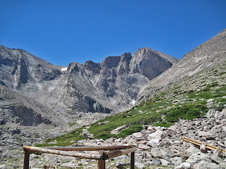
Easy: Keyhole Route (class 3)

The Keyhole Ridge with the Keyhole visible right-center
The Keyhole Route is Longs easiest and most popular route. Many thousands of hikers and scramblers do this route every year. Although it is a non-technical route, the class 3 terrain requires the use of hands for balance and upward movement and the rock is loose, and quite exposed. Snow or ice in the spring or storms in the summer can make this a serious route. The loose rock combined with the exposure and sheer volume of people on this route have made it one of the deadliest routes in Colorado. It seems that more deaths occur on this route than any other in the state.

From the Longs Peak trailhead, follow the trail for 6 miles to the Boulder Field at 12,800’. Cross the boulderfield aiming for a keyhole shaped notch in the cliffband on the right (west) side of the north face. The main flow of the trail and most cairns will lead you to this obvious notch. Once you cross through the Keyhole the nature of the route changes and gets much more difficult and exposed, making this a good place to turn around if the weather looks like it is turning.

After the Keyhole scramble along increasing exposure to the Trough, a long gully littered with loose rocks and the occasional class 3 move. Ascend the Trough for about 500 feet and pass a chockstone on either side. Many consider this the most difficult move on the route. Past the Trough continue along the Narrows, a skinny ledge that pinches in several spots to 5 feet or less above a three-hundred foot cliff. The climbing is exposed but easy. Reach the bottom of the Homestretch at the end of the Narrows. Climb a ledgy crack system and arrive abruptly on the flat summit from the south side.

Moderate: Kiener’s Route (II 5.4 Moderate Snow)

The turnoff to Chasm Lake. Upper Kiener's is visible
Kiener’s Route is a spectacular alpine journey that tackles Longs’ amazing East Face without taking on the Diamond directly. It is long, exposed and difficult and requires knowledge of both snow and rock climbing. Despite its modest technical rating, Kiener’s is a committing route that is not to be taken lightly. Approach this route with respect.

Follow the Longs Peak trail for 3.5 miles to the turnoff for Chasm Meadows. Leave the main trail and take the turn left towards Chasm Lake and Longs Peaks astounding East Face. Hike for another mile to Chasm Lake; with the Diamond and the Lower East Face towering above you, you know you are in a special place.

Hike around to the back side of Chasm to Mills Glacier (more a permanent snow field) and find the Lamb’s Slide, a steep couloir that ascends toward the Loft. Ascend moderate snow here for nearly a thousand feet. Conditions at the Lamb’s Slide can vary from good snow to steep rotten ice. Depending on which you encounter you may need either pickets or ice screws or both. Crampons and an ice axe are highly recommended.

Ascend Lamb’s Slide to where Broadway’s ledges intersect on right. Take the highest ledge. Hike along Broad way with increasing exposure until you reach the first of the route’s crux moves, a very narrows step around with dramatic exposure over the lower East Face. Many people choose to rope up here. Past this move continue to the base of the Notch Couloir.

Climb the Notch Couloir for about 40 feet and traverse right to a dihedral or pass the base of the couloir and climb rock on its right side. Either way you will encounter a pitch or two of low 5th class climbing. After passing a chimney, continue along the face staying near but not right on the edge of the Diamond’s upper edge. The exposure continues to be amazing. Near the top do a step-around near the Diamond’s apex and continue up easy scrambling to the summit. Descend with some rappels down the North Face route or scramble down the Keyhole to descend.

Hard: The Casual Route (IV 5.10a)

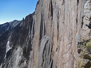
The Diamond from Chasm View
Along with Wyoming’s Grand Teton, the Diamond on Longs Peak’s east face is the most sought-after destination for alpine climbing in the Lower 48. Being the easiest way to ascend this amazing thousand-foot cliff, the Casual Route is justifiably popular and classic.

Follow the Longs Peak trail to Chasm Meadows and take the turn to Chasm Lake. Hike around the back of Chasm Lake to base of the obvious cliff, the easy part of the approach is over.  In the center of Longs’s East Face, located the North Chimney, a weakness that leads up to Broadway. Scramble, simul-climb and belay up three to four rope-lengths of moderate but notoriously loose 5.easy to 5.6 climbing to Broadway, an obvious ledge system. Now you are at the base of the climb.

P1- Climb a left-facing corner up easy rock in the middle of the D1 pillar to the base of an obvious crack. (5.4)

P2- Follow a nice crack (fingers to hands) to a possible belay stance below the infamous “flakes traverse”. Some people stop and belay here and some prefer to link and the next pitch together (5.9).

P3- The infamous traverse. Climb up and left on good holds with somewhat scant protection. It is often said that both leader and follower are on the sharp end on this pitch due to the fall potential and traversing nature. (5.7).

P4- At a spacious ledge, gain a good handcrack dihedral. Climb a long pitch to a stance near the top of the dihedral. (5.8+).

P5- Finish the dihedral and belay from the Yellow Wall bivy ledge. (5.8).

P6- The crux pitch. From the right side of the ledge, stem up a corner, negotiate a chimney and reach the crux bulge. Pull the bulge and belay at the Table Ledge. There are many pieces of fixed gear here and it is easy to rest or pull this crux with some A0. (5.10a)

P7- Traverse up and left along the Table Ledge to Upper Kiener’s Route (5.8). Follow Upper Kiener’s to the summit.

Descent: With ropes you can scramble down the North Face to a set of eyebolts. Two or three single rope raps lands you at a brief downscramble to the Boulderfield. You can also scramble down the standard Keyhole route.

LINKS

-National Park Service webcam of Longs Peak

Visit THE ARCHIVE: A list of most of our articles sorted by department

find us on facebook

Follow us on Twitter!

Copyright notice: This website and all its contents are the intellectual property of www.coloradomountaineering.com and its authors. None of the content can be used or reproduced without the approval of www.coloradomountaineering.com.

Climbing and mountaineering are dangerous!! Please see the DISCLAIMER page
For information about how to contact us, visit this link
Visit THE ARCHIVE: A list of most of our articles sorted by department


find us on facebook

Copyright notice: This website and all its contents are the intellectual property of www.coloradomountaineering.com and its authors. None of the content can be used or reproduced without the approval of www.coloradomountaineering.com.

Climbing and mountaineering are dangerous!! Please see the DISCLAIMER page
For information about how to contact us, visit this link