Visit THE ARCHIVE: A list of most of our articles sorted by department

Wednesday, October 30, 2013
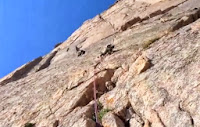
VIDEO: Independence Monument- Colorado's Moderate Desert Tower
A close-up look at a recent climb of Otto's Route (III 5.9) on Independence Tower in the Colorado National Monument. Otto's Route was first put-up in 1911 by John Otto. Though he did some major chipping (obvious in the video) he completed the climb in cowboy boots and with a hemp rope.
Visit THE ARCHIVE: A list of most of our articles sorted by department

Copyright notice: This website and all its contents are the intellectual property of www.coloradomountaineering.com and its authors. None of the content can be used or reproduced without the approval of www.coloradomountaineering.com.
Climbing and mountaineering are dangerous!! Please see the DISCLAIMER page
For information about how to contact us, visit this link
Visit THE ARCHIVE: A list of most of our articles sorted by department
Friday, October 25, 2013
VIDEO: Ashima Shiraishi Bouldering in Colorado
Ashima Shiraishi is one of the most exciting up-and-coming climbers on the scene. She exploded onto the radar of the climbing world when she became the youngest climber of either gender to climb V13 and 5.14c. In this video, we catch up with Ashima as she takes on some of the hardest bouldering problems in the state.
On the Road from Evolv Climbing on Vimeo.

Visit THE ARCHIVE: A list of most of our articles sorted by department
Copyright notice: This website and all its contents are the intellectual property of www.coloradomountaineering.com and its authors. None of the content can be used or reproduced without the approval of www.coloradomountaineering.com.
Climbing and mountaineering are dangerous!! Please see the DISCLAIMER page
For information about how to contact us, visit this link
On the Road from Evolv Climbing on Vimeo.
Visit THE ARCHIVE: A list of most of our articles sorted by department
Tuesday, October 22, 2013
Hot Route: Mount Massive, East Slopes
Length: 14 miles
Elevation gain: 4,600 feet
difficulty: class 2
OVERVIEW
Mount Massive is a mountain that fits its name. It is truly a giant among lesser Colorado peaks. Although there are shorter ways to climb Massive than this standard route, the East Slopes is the easiest path to the summit from a technical standpoint. Almost the entire climb is on a well-traveled trail. The route is long, however, compared to many standard 14er hikes, and it will earn its name long before you stand on its top.
The East Slopes route on Massive is mostly a cruise and is one of the more popular 14er climbs in the Sawatch Range and probably the state. Don't expect solitude during the summer on this route. Still, this route is one of the classic 14er hikes in the state. Mount Massive is one of Colorado most, well, massive mountains. It sheer size makes it interesting to climb and powerful to include on your ticklist.
THE ROUTE
This first three miles of this climb follow wooded and mellow trail (part of the Colorado Trail). This trail (whose trailhead is almost exactly across the street from the trailhead for the North Mount Elbert Trail) takes you from just over 10,000 feet on Massive's southeast flank around to Massive's east side. After three miles, the trail meets a junction and turns west (left) toward the basin on the mountains east slopes. This trail junction is at 11,200 feet.
From here the route turn and quickly passses treeline, turning eventually into a long basin where Massive comes into view. It might seem close from here, but distances are deceiving. It may seem in this next section, that ou are hiking and hiking towards the mountain but it just keeps getting farther away.
Finally, after another 3 miles, you reach the saddle between Mount Massive's main summit and "South Massive," an unranked 14,000 sub-summit. From here it is just a short distance up a mildly scruffy class 2 slope to the top.
DIRECTIONS
From Highway 24 approximately 3 miles south of Leadville, turn west onto Highway 300. After .8 mile turn left (south) on CR-11. 1.2 miles farther, follow signs toward Halfmoon Creek and turn right. The Mt. Massive TH is five miles farther on the right (north) side of the road. There are several National Forest campsites in the area as well as dispersed camping. The more environmentally correct option is to stay in the developed, fee-based areas. If you must set-up in dispersed areas, please avoid building fire rings, there are plenty already. The Mount Massive trailhead is about one half-mile west of the North Mt. Elbert trailhead (which is on the opposite side of the road).
TRIP REPORTS
Redemption on Mount Massive- After turning around on Mt. Massive the year before due to lightning, we returned in 2011 to battle deep, rotten snow and a late-spring snowstorm to make the summit just in time to glissade down.
LINKS
Mt. Massive on 14ers.com
Mt. Massive on summitpost.org
Copyright notice: This website and all its contents are the intellectual property of www.coloradomountaineering.com and its authors. None of the content can be used or reproduced without the approval of www.coloradomountaineering.com.
Climbing and mountaineering are dangerous!! Please see the DISCLAIMER page
For information about how to contact us, visit this link
Elevation gain: 4,600 feet
difficulty: class 2
OVERVIEW
 |
| Mount Massive East Slopes |
The East Slopes route on Massive is mostly a cruise and is one of the more popular 14er climbs in the Sawatch Range and probably the state. Don't expect solitude during the summer on this route. Still, this route is one of the classic 14er hikes in the state. Mount Massive is one of Colorado most, well, massive mountains. It sheer size makes it interesting to climb and powerful to include on your ticklist.
THE ROUTE
This first three miles of this climb follow wooded and mellow trail (part of the Colorado Trail). This trail (whose trailhead is almost exactly across the street from the trailhead for the North Mount Elbert Trail) takes you from just over 10,000 feet on Massive's southeast flank around to Massive's east side. After three miles, the trail meets a junction and turns west (left) toward the basin on the mountains east slopes. This trail junction is at 11,200 feet.
 |
| Late spring conditions on Massive |
Finally, after another 3 miles, you reach the saddle between Mount Massive's main summit and "South Massive," an unranked 14,000 sub-summit. From here it is just a short distance up a mildly scruffy class 2 slope to the top.
DIRECTIONS
TRIP REPORTS
Redemption on Mount Massive- After turning around on Mt. Massive the year before due to lightning, we returned in 2011 to battle deep, rotten snow and a late-spring snowstorm to make the summit just in time to glissade down.
LINKS
Mt. Massive on 14ers.com
Mt. Massive on summitpost.org
|
|


Visit THE ARCHIVE: A list of most of our articles sorted by department
Friday, October 18, 2013
Video: The Casual Route (IV 5.10a)
No pro or big name climbers, but this video takes a good look at the Casual Route (IV 5.10a) on Longs Peak's world-famous Diamond. The Casual Route is the easiest route on this classic face:
Visit THE ARCHIVE: A list of most of our articles sorted by department
Copyright notice: This website and all its contents are the intellectual property of www.coloradomountaineering.com and its authors. None of the content can be used or reproduced without the approval of www.coloradomountaineering.com.
Climbing and mountaineering are dangerous!! Please see the DISCLAIMER page
For information about how to contact us, visit this link

Visit THE ARCHIVE: A list of most of our articles sorted by department
Monday, October 14, 2013
LIST: Ranked Class 5 Peaks over 13,000 feet
There are seven "ranked" peaks over 13,000 feet that require class 5 climbing to reach the top. In other words, by their easiest route, these seven mountains are the most difficult high peaks in the state. Mountains like Longs Peak or Crestone Needle which have difficult class 5 routes but easier hikes or scrambles as well would not be included. This list also does not include mountains like "Coffeepot" which require fifth-class climbing to reach their summit but do not meet the requirements for being "ranked" (i.e. they have less than 300 feet of topographical prominence).
There are three peaks in the Centennial list (100 highest) that require 5th class climbing. As you will see below, there are four other 13ers that also fall in this intimidating category. It is interesting, though not altogether surprising, that all of the mountains on this list (except the debatable "Whitney Peak") are found in the San Juan Range.
NOTE: I believe this list is complete but there are 637 mountains in Colorado that are above 13,000 feet and have more than 300 feet of topographical prominence. Many of these peaks are quite obscure and have seen only a handful of ascents. If you know of a ranked summit that requires 5th class rock climbing by its easiest route than please let me know!
1. Jagged Mountain (13,824 feet) (5.2)
Deep in the Weminuche Wildnerness lies one of Colorado's most reclusive and inaccessible mountains. Jagged Mountain is a jewel of Colorado mountaineering and deserves a larger reputation than it has. This hard-to-reach mountain is one of the few in the state that requires more than one day to climb. The route itself is a winding, complicated multi-pitch climb with dangerous scrambling, loose rock, tricky routefinding, and several technical cruxes that probably necessitate the use of a rope. There is a great deal of exposure, including a narrow ledge traverse with thousands of feet of air whipping at your ankles.
2. Teakettle Mountain (13,819 feet) (class 5.2)
Teakettle is part of a rugged portion of the San Juans that includes several challenging peaks: Sneffels, Coffeepot, Dallas, and Teakettle. Of the three Centennials on this list, Teakettle is probably the easiest summit to reach. There is a 50-foot 5.2-5.3 summit pitch leading up the unique summit cap (hmmm...why did this mountain get its name?) to an exhilarating and tiny summit.
3. Dallas Peak (13,809 feet) (class 5.3)
Dallas Peak is often cited as the most difficult of Colorado's 100 highest peaks. Dallas's challenging summit cap is generally given a high-end 5.3 rating. The last two hundred feet on Dallas are steep, junky and full of class 4 and 5 terrain. The most difficult moves are just below the summit. You can rappel from near the summit directly past most of the hardest difficulties.
4. Peak Fifteen (13,700) (class 5.2)
Peak Fifteen is the next-door neighbor to more famous 13er Turret Peak and both of these rugged mountains lie in Weminuche Wilderness Area in the San Juans. This technical and committing route is one of the hardest all-around climbs of all the standard routes in the state and most people bring a rope. Peak Sixteen, Peak Fifteen's unranked neighbor, is also a technical mountaineering goal requiring 5th class climbing to reach its summit and together these three mountains for an amazing and impressive massif.
5. Coxcomb Peak (13,656 feet) (class 5.3)
Probably the easiest peak on this list, Coxcomb involves just a short section of class 5 climbing. This flat-topped peak is not particularly imposing but can surprise you. Coxcomb is known for loose rock, poor protection, and some exposure on the summit ridge. Be prepared to rappel.
6. Whitney Peak (13,276') (class 5.6)
Inclusion of this peak is up for debate, as the "class 5" section of it is one boulder. Apparently, however, this boulder is the highest point on the peak and thus to truly climb the peak in the eyes of some you must stand on the top of the boulder. Apparently, scaling this boulder takes a few moves of class 5.6 "climbing."
7. Lizard's Head (13,113 feet) (5.8+ R/X)
Simply put, Lizard's Head is Colorado's hardest ranked peak above 13,000 feet. This intimidating spire is a rotten, exposed nightmare and thus is rarely climbed. The easiest route is the Southwest Chimney, a three-pitch climb on runout choss. There are other possibilities too, all of which are going to require equally or more difficult technical climbing.
Honorable mention:
Sunlight Spire (13,995 feet) (5.10c)
Though it does not meet the criteria to be a ranked peak as it has only 215 feet of topographical prominence, Sunlight Spire is one of Colorado's most dramatic and difficult summits to reach. To add to its allure, the summit pitch is a beautiful and bomber splitter-crack that clocks in at the high 5.10 level. This crack can be freeclimbed or aided (see this photograph for a good view of the amazing summit cap). Based on the more accurate but less syndicated 1988 datum, Sunlight Spire just overtops 14,000 feet, possibly making it the most difficult 14,000 foot summit in the contiguous 48, even more difficult than the famous summit cap on California's Thunderbolt Peak, which, by the way, is also "unranked" by Colorado standards yet considered one of the must-do California 14ers.
Follow us on Twitter!
Copyright notice: This website and all its contents are the intellectual property of www.coloradomountaineering.com and its authors. None of the content can be used or reproduced without the approval of www.coloradomountaineering.com.
Climbing and mountaineering are dangerous!! Please see the DISCLAIMER page
For information about how to contact us, visit this link
There are three peaks in the Centennial list (100 highest) that require 5th class climbing. As you will see below, there are four other 13ers that also fall in this intimidating category. It is interesting, though not altogether surprising, that all of the mountains on this list (except the debatable "Whitney Peak") are found in the San Juan Range.
NOTE: I believe this list is complete but there are 637 mountains in Colorado that are above 13,000 feet and have more than 300 feet of topographical prominence. Many of these peaks are quite obscure and have seen only a handful of ascents. If you know of a ranked summit that requires 5th class rock climbing by its easiest route than please let me know!
 |
| Dallas Peak from Blue Lake Pass |
Deep in the Weminuche Wildnerness lies one of Colorado's most reclusive and inaccessible mountains. Jagged Mountain is a jewel of Colorado mountaineering and deserves a larger reputation than it has. This hard-to-reach mountain is one of the few in the state that requires more than one day to climb. The route itself is a winding, complicated multi-pitch climb with dangerous scrambling, loose rock, tricky routefinding, and several technical cruxes that probably necessitate the use of a rope. There is a great deal of exposure, including a narrow ledge traverse with thousands of feet of air whipping at your ankles.
2. Teakettle Mountain (13,819 feet) (class 5.2)
Teakettle is part of a rugged portion of the San Juans that includes several challenging peaks: Sneffels, Coffeepot, Dallas, and Teakettle. Of the three Centennials on this list, Teakettle is probably the easiest summit to reach. There is a 50-foot 5.2-5.3 summit pitch leading up the unique summit cap (hmmm...why did this mountain get its name?) to an exhilarating and tiny summit.
3. Dallas Peak (13,809 feet) (class 5.3)
Dallas Peak is often cited as the most difficult of Colorado's 100 highest peaks. Dallas's challenging summit cap is generally given a high-end 5.3 rating. The last two hundred feet on Dallas are steep, junky and full of class 4 and 5 terrain. The most difficult moves are just below the summit. You can rappel from near the summit directly past most of the hardest difficulties.
4. Peak Fifteen (13,700) (class 5.2)
Peak Fifteen is the next-door neighbor to more famous 13er Turret Peak and both of these rugged mountains lie in Weminuche Wilderness Area in the San Juans. This technical and committing route is one of the hardest all-around climbs of all the standard routes in the state and most people bring a rope. Peak Sixteen, Peak Fifteen's unranked neighbor, is also a technical mountaineering goal requiring 5th class climbing to reach its summit and together these three mountains for an amazing and impressive massif.
5. Coxcomb Peak (13,656 feet) (class 5.3)
Probably the easiest peak on this list, Coxcomb involves just a short section of class 5 climbing. This flat-topped peak is not particularly imposing but can surprise you. Coxcomb is known for loose rock, poor protection, and some exposure on the summit ridge. Be prepared to rappel.
6. Whitney Peak (13,276') (class 5.6)
Inclusion of this peak is up for debate, as the "class 5" section of it is one boulder. Apparently, however, this boulder is the highest point on the peak and thus to truly climb the peak in the eyes of some you must stand on the top of the boulder. Apparently, scaling this boulder takes a few moves of class 5.6 "climbing."
 |
| Lizard Head Peak- Colorado's most difficult summit over 13,000' |
Honorable mention:
Sunlight Spire (13,995 feet) (5.10c)
Though it does not meet the criteria to be a ranked peak as it has only 215 feet of topographical prominence, Sunlight Spire is one of Colorado's most dramatic and difficult summits to reach. To add to its allure, the summit pitch is a beautiful and bomber splitter-crack that clocks in at the high 5.10 level. This crack can be freeclimbed or aided (see this photograph for a good view of the amazing summit cap). Based on the more accurate but less syndicated 1988 datum, Sunlight Spire just overtops 14,000 feet, possibly making it the most difficult 14,000 foot summit in the contiguous 48, even more difficult than the famous summit cap on California's Thunderbolt Peak, which, by the way, is also "unranked" by Colorado standards yet considered one of the must-do California 14ers.
Visit THE ARCHIVE: A list of most of our articles sorted by department
Thursday, October 10, 2013
NEWS: Wild Country Recall (10/10/13)

Wild Country has released a pdf sheet with information about the reasons for the recall and how you can identify whether or not the gear you own is included in this recall. The way to know is to check the "batch code" of your product, which is imprinted on the plastic tab at the throat of the loop portion of the wire (see photo below). If the batch code on your Rocks or Anodized Rocks is either AG, AH, AII, or JBE then you should contact the company for more instructions. In particular, batch JBE was found to be especially faulty, with pieces rated up to 12 kN sometimes failing below 7 kN.

Wednesday, October 9, 2013
Peak of the Week: Crestone Peak (14,294 feet)
INTRO
Without question, Crestone Peak is one of Colorado's most spectacular mountains. It is the anchor of the Sangre De Cristo Range, and its crown jewel. It is rugged, picturesque and intimidating. In terms of mountaineering, climbers will find that "The Peak" is one of the most challenging and technically difficult of Colorado's 14ers. But for the advanced mountaineer, more options are available on the rugged peaks of this massif than almost anywhere else in the state.
Crestone Peak is a classic mountain, one that Colorado can be proud of. The Sangres in general leap from the surrounding valleys with abrupt and awe-inspiring sharpness. These mountains define what it means to be rugged. As Colorado's 7th highest peak, Crestone Peak is the tallest mountain in the state that requires class 3 scrambling to obtain its summit.
Composed of cobbled, conglomerate rock, Crestone Peak and its neighbors are unique to Colorado geology, and climbing them is an experience that no mountaineer, either native or visiting, could ever forget. It is a mountain and a range with a unique personality.
DIRECTIONS
South Colony Lake Trailhead- South Colony Lake is the ideal and most popular base camp for the majority of Crestone Peak routes. It is a good base of operations, in fact, for most of the neighboring peaks as well, making multiple-summit trips logistically viable. From Westcliffe, follow Highway 69 for 4.5 miles south. Veer south (right) onto Colfax Lane (County Road 119). Follow this road straight until you reach a T-intersection with Country Road 120 (South Colony Road). Turn right and follow this road 1.5 miles to the trailhead. 4WD vehicles can continue for as many as four more miles to a high trailhead at 11,000 feet. This road is notoriously bad and sometimes a gate may block it off at 9,800 feet.
ROUTES
South Face (class 3, moderate snow)-
The South Face route on Crestone Peak is almost always the easiest route on the peak. However, this route is long, complicated and almost always entails ascending some moderate sections of snow. From South Colony Lakes, climb a couloir to Broken Hand Pass. Descend to Cottonwood Lake (accessible via a long trail through private property with permission) and climb a vague couloir up the south face to a notch between the main summit and a sub-summit. Scramble a couple hundred more feet to the top.
Northwest Couloir (class 3, steep snow/ice)-
This route is more straightforward and entails less elevation gain than the South Face route, but is generally more difficult and dangerous. Depending on conditions, the couloir with either be a steep but good snow climb, or a mess of icy, rubble-infested ledges. A helmet, crampons and ice axe are recommended in almost any season.
Peak to Needle Traverse (class 5.2, moderate snow)- This popular and challenging traverse is listed in Gerry Roach's guidebook Colorado's Fourteeners: From Hikes to Climbs as "one of Colorado's four great Fourteener traverses" and for good reason. This route is a spectacular way to visit both of these astounding Colorado peaks. Though originally listed as class 4, standard consensus these days is that there is some limited low class 5 terrain on this route. The most popular way to tackle this route is by climbing Crestone Peak's Northwest Couloir route first, traversing from Peak to Needle, and descending Crestone Needle's South Face. Arguments have been made for doing the traverse in the opposite direction of for starting on the Peak's South Face route instead. This all depends on your skill and mountain conditions. One thing is for sure that this route is long, committing and complicated so plan accordingly.
North Pillar (class 5.8)-
This is the premier technical route on Crestone Peak, and one of the harder alpine climbing in the Sangres. It is not as popular or well-known as the Ellingwood Arete (see a video of climbers on the Ellingwood Arete) on Crestone Needle but is still worth mentioning here. The North Pillar is a ten-pitch climb on the mountain's northeast face, with the crux 5.8 pitch coming about two-thirds of the way up. Be prepared for runouts, complicated route-finding, and some unforgettable knob-pulling on the famous Sangre conglomerate!
SPECIAL CONSIDERATIONS
The South Colony Lakes are in the Sangre De Cristo Wilderness Area and special regulations apply. These mostly focus on the carryout of waste. Check out the fact sheet for the Sangre De Cristo Wilderness Area for more information.
LINKS
Crestone Peak on 14ers.com
The Crestones on mountainproject.com
Crestone Peak on Summitpost.org
Visit THE ARCHIVE: A list of most of our articles sorted by department
Copyright notice: This website and all its contents are the intellectual property of www.coloradomountaineering.com and its authors. None of the content can be used or reproduced without the approval of www.coloradomountaineering.com.
Climbing and mountaineering are dangerous!! Please see the DISCLAIMER page
For information about how to contact us, visit this link
 |
| Late fall dusting of snow of Crestone Peak and its neighbor Crestone Needle |
Crestone Peak is a classic mountain, one that Colorado can be proud of. The Sangres in general leap from the surrounding valleys with abrupt and awe-inspiring sharpness. These mountains define what it means to be rugged. As Colorado's 7th highest peak, Crestone Peak is the tallest mountain in the state that requires class 3 scrambling to obtain its summit.
Composed of cobbled, conglomerate rock, Crestone Peak and its neighbors are unique to Colorado geology, and climbing them is an experience that no mountaineer, either native or visiting, could ever forget. It is a mountain and a range with a unique personality.
DIRECTIONS
South Colony Lake Trailhead- South Colony Lake is the ideal and most popular base camp for the majority of Crestone Peak routes. It is a good base of operations, in fact, for most of the neighboring peaks as well, making multiple-summit trips logistically viable. From Westcliffe, follow Highway 69 for 4.5 miles south. Veer south (right) onto Colfax Lane (County Road 119). Follow this road straight until you reach a T-intersection with Country Road 120 (South Colony Road). Turn right and follow this road 1.5 miles to the trailhead. 4WD vehicles can continue for as many as four more miles to a high trailhead at 11,000 feet. This road is notoriously bad and sometimes a gate may block it off at 9,800 feet.
ROUTES
South Face (class 3, moderate snow)-
The South Face route on Crestone Peak is almost always the easiest route on the peak. However, this route is long, complicated and almost always entails ascending some moderate sections of snow. From South Colony Lakes, climb a couloir to Broken Hand Pass. Descend to Cottonwood Lake (accessible via a long trail through private property with permission) and climb a vague couloir up the south face to a notch between the main summit and a sub-summit. Scramble a couple hundred more feet to the top.
Northwest Couloir (class 3, steep snow/ice)-
 |
| Crestone Peak stands proud |
Peak to Needle Traverse (class 5.2, moderate snow)- This popular and challenging traverse is listed in Gerry Roach's guidebook Colorado's Fourteeners: From Hikes to Climbs as "one of Colorado's four great Fourteener traverses" and for good reason. This route is a spectacular way to visit both of these astounding Colorado peaks. Though originally listed as class 4, standard consensus these days is that there is some limited low class 5 terrain on this route. The most popular way to tackle this route is by climbing Crestone Peak's Northwest Couloir route first, traversing from Peak to Needle, and descending Crestone Needle's South Face. Arguments have been made for doing the traverse in the opposite direction of for starting on the Peak's South Face route instead. This all depends on your skill and mountain conditions. One thing is for sure that this route is long, committing and complicated so plan accordingly.
North Pillar (class 5.8)-
This is the premier technical route on Crestone Peak, and one of the harder alpine climbing in the Sangres. It is not as popular or well-known as the Ellingwood Arete (see a video of climbers on the Ellingwood Arete) on Crestone Needle but is still worth mentioning here. The North Pillar is a ten-pitch climb on the mountain's northeast face, with the crux 5.8 pitch coming about two-thirds of the way up. Be prepared for runouts, complicated route-finding, and some unforgettable knob-pulling on the famous Sangre conglomerate!
SPECIAL CONSIDERATIONS
The South Colony Lakes are in the Sangre De Cristo Wilderness Area and special regulations apply. These mostly focus on the carryout of waste. Check out the fact sheet for the Sangre De Cristo Wilderness Area for more information.
LINKS
Crestone Peak on 14ers.com
The Crestones on mountainproject.com
Crestone Peak on Summitpost.org
Visit THE ARCHIVE: A list of most of our articles sorted by department
Tuesday, October 8, 2013
VIDEO: Ellingwood Arete
A comprehensive look at the Ellingwood Arete (also called the Ellingwood Ledges) on Crestone Needle. The Ellingwood Arete was included in the famous guideboook Fifty Classic Climbs of North America and thus maintains a certain dignity and respect in the climbing community abroad. This is a good and challenging climb and this gives you an idea what it entails:

Visit THE ARCHIVE: A list of most of our articles sorted by department
Copyright notice: This website and all its contents are the intellectual property of www.coloradomountaineering.com and its authors. None of the content can be used or reproduced without the approval of www.coloradomountaineering.com.
Climbing and mountaineering are dangerous!! Please see the DISCLAIMER page
For information about how to contact us, visit this link

Visit THE ARCHIVE: A list of most of our articles sorted by department
Thursday, October 3, 2013
Feature: Lost in the San Juans
The Grenadiers:
A Week of Rain, Lightning and Getting Lost in Colorado’s Largest Wilderness
by Brian Wright
I’d lost my fiancée. Sometime between when she yelled ahead to tell me she wanted to stop and take photos of some flowers and when I’d sat three minutes later on a log to wait for her to catch up, we’d gotten separated. “Ella!” I screamed at the top of my lungs, running in my heavy hiking boots back up the steep trail towards Vestal Basin. My legs were tired, my ankle injured. We had just spent the previous day battling up the 1,500-foot trail from Elk Creek to the base of Vestal Peak in Colorado’s Weminuche Wilderness on a trail that had proven not to be a trail at all. What we had hoped would be a short, albeit steep, hike had turned into a multi-hour obstacle course of downed lumber and loose rock.
An hour had gone by since we’d last seen each other. The worst of all possibilities were surfacing in my mind. Maybe she’d fallen on the uneven “trail”. Maybe she’d had to go back to camp for a forgotten item. The horrifying thought even occurred to me, since she’d seemingly disappeared without a trace, that a mountain lion had dragged her off the trail. At that point, anything seemed possible.
The clouds were building, again. Although we had had a morning of beautiful blue skies, already the storms that had dominated every afternoon of our week-long backpack trip were returning. I ran farther up the trail, almost all the way back to our camp from the previous evening. There was no sign of her. “Where did you go?” I yelled fruitlessly. I’d read about people in situations like this, but I’d never been in one myself. I needed to find someone to help. I needed to find her. As the storms built and my desperation deepened, I knew there was no way I could leave Vestal Basin until I found her.
* * *
The Weminuche Wilderness Area is the largest wilderness in Colorado. At nearly half a million acres, it encompasses a huge swath of the San Juan Mountains in-between the towns of Durango and Silverton. There are over 500 miles of trails through the Weminuche, including a portion of the popular Colorado Trail, and countless other rugged passes and unmaintained routes.
But it wasn’t the trails that we had come for, but the mountains, and no other place in the state boasts so rugged and dramatic a collection of high peaks. In ten square miles at the heart of the Weminuche, there are 10 of Colorado’s 104 highest peaks, including four fourteeners (Sunlight, Eolus, North Eolus, and Windom) and many of Colorado’s most classic thirteeners. Our sights had been set on the Grenadier Range, a sub-range of the San Juan Mountains that runs east to west a few miles south of Silverton. The Grenadiers are a chain of dramatic quartzite peaks that form one of Colorado’s most unique and dramatic mountain skylines. Great ramps of solid, dark rock angle into the sky. In his book Colorado’s Thirteeners: 13,800 to 13,999 Feet, Gerry Roach says that the mountains of the Grenadier Range “take on a new dimension as peaks leap from a mold that could belong to another planet.” It was this unique architecture that drew us to these mountains, for some of the best and most popular technical alpine climbs in the state reside here.
Our plan had been to start at the Molas Trailhead (thereby foregoing the $85 train ride from Durango into the Animas River Canyon, which would have saved us over six miles and 1,800 feet of both elevation gain and loss) and hike down along a portion of the Colorado Trail until we could turn south into the Vestal Basin. We wanted to establish a high camp in the Vestal Basin at 11,500 feet at the very foot of the Grenadier Mountains. There we would be in perfect position to attempt the North Ridge of Arrow Peak (III 5.6) and, more importantly, Wham Ridge of Vestal Peak (II 5.4).
In every good story, however, the heroes (us) are thrown into a vibrant setting and obstacles are strewn in front of their path, the more the better. Such was the case for us as we started our journey in the rain on my 30th birthday. We encountered massive, drenching storms with wild lightning and pounding hail. We met hungry animals, steep hills, downed lumber, deceptive forks in the trail. We faced all of these with 70-pound packs laden with a week’s worth of gear and our entire supply of climbing gear hanging from our shoulders. But none of it was as frightening and mentally exhausting as losing each other.
An hour into my frantic search and there was still no sign of her. My voice was rough from shouting. It all seemed impossible, like a bad dream I couldn’t shake. I wanted to go home. After four days of rain and lightning and never having a weather window for us to attempt either peak, I was spent.
The only logical solution, I concluded at last, was that somehow she had gotten ahead of me. But how? I had sat and waited on the trail and she had never passed me. The only choice, it seemed, was to head down. It was a difficult decision; if she was in trouble and needed help I might be her only hope for a rescue. Shouldering my pack reluctantly, I start down the long hill.
Quickly, I found myself somewhere unrecognizable and the harsh truth settled in: it had been me who had taken the wrong trail. I had to back-track until I realized exactly where I had gotten off course. Finally back on the right path, I started downhill as fast as I could, knowing that somewhere below Ella was likely in a desperate panic just like me, thinking I too was lost. I found footprints fresh since the rain of the night before. They had to be hers.
At the bottom of the hill we were reunited at last, each as emotional as the other. We sat together resting, exhausted by our simultaneous searches for each other. After the emotions subsided we were able to laugh it off like a bad joke.
The trip wasn’t quite what we’d hoped it would be. We didn’t make either summit, we got rained on incessantly, and both of our bodies were breaking down with the enormous effort. But as we settled next to the Animas River for our last night before we hiked up the big hill back to our car, we were happy. We’d had a great adventure in one of Colorado’s most breathtaking places.
Note: This article first appeared in the September 2013 edition (Volumne Eight, Issue Five) of Our Backyard, which is a special edition inside The Nickel, the Moab Times Independent, the Fruita Times, and the Palisade Tribune
Visit THE ARCHIVE: A list of most of our articles sorted by department
Copyright notice: This website and all its contents are the intellectual property of www.coloradomountaineering.com and its authors. None of the content can be used or reproduced without the approval of www.coloradomountaineering.com.
Climbing and mountaineering are dangerous!! Please see the DISCLAIMER page
For information about how to contact us, visit this link
A Week of Rain, Lightning and Getting Lost in Colorado’s Largest Wilderness
by Brian Wright
 |
| Arrow and Vestal Peak coming out of the fog |
An hour had gone by since we’d last seen each other. The worst of all possibilities were surfacing in my mind. Maybe she’d fallen on the uneven “trail”. Maybe she’d had to go back to camp for a forgotten item. The horrifying thought even occurred to me, since she’d seemingly disappeared without a trace, that a mountain lion had dragged her off the trail. At that point, anything seemed possible.
The clouds were building, again. Although we had had a morning of beautiful blue skies, already the storms that had dominated every afternoon of our week-long backpack trip were returning. I ran farther up the trail, almost all the way back to our camp from the previous evening. There was no sign of her. “Where did you go?” I yelled fruitlessly. I’d read about people in situations like this, but I’d never been in one myself. I needed to find someone to help. I needed to find her. As the storms built and my desperation deepened, I knew there was no way I could leave Vestal Basin until I found her.
The Weminuche Wilderness Area is the largest wilderness in Colorado. At nearly half a million acres, it encompasses a huge swath of the San Juan Mountains in-between the towns of Durango and Silverton. There are over 500 miles of trails through the Weminuche, including a portion of the popular Colorado Trail, and countless other rugged passes and unmaintained routes.
 |
| Wham Ridge of Vestal Peak in the Grenadier Range of the San Juan Montains |
Our plan had been to start at the Molas Trailhead (thereby foregoing the $85 train ride from Durango into the Animas River Canyon, which would have saved us over six miles and 1,800 feet of both elevation gain and loss) and hike down along a portion of the Colorado Trail until we could turn south into the Vestal Basin. We wanted to establish a high camp in the Vestal Basin at 11,500 feet at the very foot of the Grenadier Mountains. There we would be in perfect position to attempt the North Ridge of Arrow Peak (III 5.6) and, more importantly, Wham Ridge of Vestal Peak (II 5.4).
In every good story, however, the heroes (us) are thrown into a vibrant setting and obstacles are strewn in front of their path, the more the better. Such was the case for us as we started our journey in the rain on my 30th birthday. We encountered massive, drenching storms with wild lightning and pounding hail. We met hungry animals, steep hills, downed lumber, deceptive forks in the trail. We faced all of these with 70-pound packs laden with a week’s worth of gear and our entire supply of climbing gear hanging from our shoulders. But none of it was as frightening and mentally exhausting as losing each other.
 |
| Rainy and foreboding, views like this dominated our trip |
The only logical solution, I concluded at last, was that somehow she had gotten ahead of me. But how? I had sat and waited on the trail and she had never passed me. The only choice, it seemed, was to head down. It was a difficult decision; if she was in trouble and needed help I might be her only hope for a rescue. Shouldering my pack reluctantly, I start down the long hill.
Quickly, I found myself somewhere unrecognizable and the harsh truth settled in: it had been me who had taken the wrong trail. I had to back-track until I realized exactly where I had gotten off course. Finally back on the right path, I started downhill as fast as I could, knowing that somewhere below Ella was likely in a desperate panic just like me, thinking I too was lost. I found footprints fresh since the rain of the night before. They had to be hers.
At the bottom of the hill we were reunited at last, each as emotional as the other. We sat together resting, exhausted by our simultaneous searches for each other. After the emotions subsided we were able to laugh it off like a bad joke.
The trip wasn’t quite what we’d hoped it would be. We didn’t make either summit, we got rained on incessantly, and both of our bodies were breaking down with the enormous effort. But as we settled next to the Animas River for our last night before we hiked up the big hill back to our car, we were happy. We’d had a great adventure in one of Colorado’s most breathtaking places.
Note: This article first appeared in the September 2013 edition (Volumne Eight, Issue Five) of Our Backyard, which is a special edition inside The Nickel, the Moab Times Independent, the Fruita Times, and the Palisade Tribune
 |  |  |
Subscribe to:
Posts (Atom)