Monday, July 13, 2015

Peak of the Week: Mount Massive

INTRO
Mt. Massive's South Slopes route
The South Slopes route from just above treeline
Mount Massive is one of Colorado's most magnificent and gigantic peaks. With seven distinct summits, four of which are over 14,000 feet, Massive is almost more of a sub-range or a massif than a singular peak. As most everyone knows by now, Massive is the second-highest peak in Colorado and the third highest in the lower 48. By almost any measure, Massive is one of Colorado's most impressive mountains.

There are several routes up Mount Massive, from the relatively easy South Slopes standard route (class 2) to the scrambling ridgeline that connects North Massive to Massive proper to the marathon nine-summit "Massive Mania," which truly traverses the entirety of this great mountain. By the time you have completed your visit to this majestic peak you will understand its reputation and its name.


DIRECTIONS
Mount Massive TH
From Leadville, drive 3.5 miles south on Highway 24. Turn onto CR 300. Follow this road for 7 miles to the obvious trailhead just past the trailhead for Mt. Elbert on the left side of the road, Half Moon Campground (right side of road) and over a creek crossing. The trailhead on the right.

North Half Moon TH
Follow the directions for the Mount Massive TH. Continue past the Mount Massive TH for 2 miles to a junction. The road may be 4WD beyond this point. Continue straight for another half mile to the trailhead.

Windsor Lake TH
From downtown Leadville drive 4.5 miles west to Turquoise Lake. Cross over the dam and follow Hagerman Pass Road for 7 miles. Park on the north side of the road, cross over the Carlton Diversion tunnel and find the start of the trail after crossing a small stream.


ROUTES
East Slopes (13.5 miles; 4,531' elevation gain; class 2)
This is the standard route on Mount Massive and is a walk-up classic. One drawback, however, is that being the easiest route on Colorado's second highest peak, it is popular. Don't expect solitude unless you go in the off season.
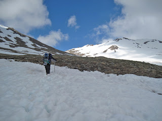
rotten snow on Mt. Massive in the late spring
Slogging up snowfields on the South Slopes in late spring
This route starts at the popular Mount Massive TH very close to the Mount Elbert TH and Half Moon Creek campground. It contours along the base of the peak, following the Colorado Trail for 3.5 miles. Turn left (don't miss this junction) onto the Mount Massive Trail at 11,300' and follow it through the trees until you emerge in the gigantic basin on Massive's east side. The summit doesn't look far away, but the distance is deceiving.

Follow the well-trodden trail for 3 miles as it climbs to the saddle on Massive's southern shoulder (between Massive and unranked "South Massive". This saddle is at 13,900'. Follow the rocky ridgeline to the summit and take in the view.

Southwest Slopes (5.8 miles; 4,001' elevation gain; class 2)
This steep, abridged route is the shortest way to climb Massive and avoids most of the crowds of the South Slopes. From the Half Moon TH, follow the trail northwest  to 11,200' and locate a tricky-to-find hiker's trail that cuts north up a gully. Weave through some broken cliffs, climbing very steeply and join the Eat slopes route just above the saddle and follow this to the summit.

Massive Mania (11.9 miles; 4,953' elevation gain; class 3)
This impressive route is accomplished via a car-shuttle and collects all nine of Massive's numerous summits. This incredible journey gives you the full Massive experience. Starting at the Lake Windsor TH follow the Continental Divide along the lofty ridge of Massive's massif until you reach North Massive, a "possibly ranked" 14er. Descend southwest along a scrambly class 3 ridge to "Massive Green" and continue the traverse along easier terrain to Massive's main summit. Continue the exposed ridge traverse to "South Massive" and "South South Massive" and finally over Point 12,381. Descend to the Mount Massive TH and congratulate yourself on an incredible journey.

SPECIAL CONSIDERATIONS
By every route, Massive is a big mountain. The standard route is long and exhausting, and almost every route on the mountain will carry you high above treeline for long periods of time. Take careful consideration about the weather forecast and don't get caught on Massive's long ridges in a thunderstorm.


LINKS
Mount Massive on 14ers.com

Mount Massive on Summitpost.org

Visit THE ARCHIVE: A list of most of our articles sorted by department

find us on facebook


Copyright notice: This website and all its contents are the intellectual property of www.coloradomountaineering.com and its authors. None of the content can be used or reproduced without the approval of www.coloradomountaineering.com.

Climbing and mountaineering are dangerous!! Please see the DISCLAIMER page
For information about how to contact us, visit this link


Saturday, July 11, 2015

NEWS (7/11/2015): Andrew Hamilton Breaks 14ers Speed Record

Andrew Hamilton has broken the speed record by climbing all of Colorado's 14,000 foot peaks in 9 days, 21 hours and 51 minutes. This incredible feat speaks to the possibilities of human endurance, determination and pure athleticism. Hamilton completed the historic achievement on Longs Peak thursday morning on Longs Peak. Congratulations on an inspiring achievement.

Longs Peak, the Diamond and the Keyhole from the Boulderfield
Longs Peak with the Diamond and North Face visible from the Boulderfield where
Andrew Hamilton broke the speed record for climbing all of Colorado's 14,000-foot peaks
Check out an interview with Hamilton on 9news.com

Visit THE ARCHIVE: A list of most of our articles sorted by department

find us on facebook


Copyright notice: This website and all its contents are the intellectual property of www.coloradomountaineering.com and its authors. None of the content can be used or reproduced without the approval of www.coloradomountaineering.com.

Climbing and mountaineering are dangerous!! Please see the DISCLAIMER page
For information about how to contact us, visit this link


Monday, July 6, 2015

HOT ROUTE: Two Ears-Zanzibar Dihedral (300', 5.8+)

Trailhead: Weller Lake Campground
Distance: 1 mile
Elevation gain: 800 feet
Difficulty: 2 pitches, 5.8+

OVERVIEW
While not a summit-reaching climb, Independence Pass's Two Ears- Zanzibar Dihedral is one route that any intermediate, technical alpine climber might be interested in. This 300' climb highlights two long pitches on superb granite with good protection in a spectacular alpine setting. While a steep and rough talus approach may deter some climbers, those who brave the rocky beginning are rewarded with an excellent climb that finishes in the classic 150' dihedral pitch the "Zanzibar Dihedral."

THE ROUTE
Approach- From the Weller Campground find a climber's trail behind campsite number 6 and wind (briefly) through the pine and Aspen trails. Follow a series of cairns for the path of least resistance or pick your own way up to the base of the obvious 300' wall.

Zanzibar Dihedral, used courtesy of Mountainproject.com
Pitch One- "Two Ears" (5.7)- This long pitch is often regarded as a climb unto itself. Start just right of a pine tree on some obvious jugs. Work up and right to a series of broken cracks. The protection is good and solid throughout. There are many possibilities for cams and nuts. Small cams finger size and less are most useful. Work past two old pitons to a good splitter that ends in a pod. Work up and right to a two-bolt anchor just off a large ledge at the base of the dihedral.

Pitch 2- "Zanibar Dihedral" (5.8+)- This long, excellent pitch scales an overhanging dihedral with great protection and plentiful face holds to make it through. Several layers of cracks allow a variety of gear to protect. At the final bulge, step right on face holds and back left to easier ground at the top. A classic, granite dihedral!

DESCENT
Two double-rope raps from chain anchors will lead you to the ground. It will require two 60 meter ropes to make the descent.

DIRECTIONS
From the "S-Turn" in downtown Aspen, Colorado, follow Highway 82 south towards Independence Pass for 7.8 miles. Park either on the right side of road (heading from Aspen to Indy Pass) at the Weller Lake TH or set-up a basecamp in the excellent campground across the road.

LINKS
Zanzibar Dihedral on Mountainprojet.com

Visit THE ARCHIVE: A list of most of our articles sorted by department

find us on facebook


Copyright notice: This website and all its contents are the intellectual property of www.coloradomountaineering.com and its authors. None of the content can be used or reproduced without the approval of www.coloradomountaineering.com.

Climbing and mountaineering are dangerous!! Please see the DISCLAIMER page
For information about how to contact us, visit this link


Friday, July 3, 2015

Following the Chipped Footsteps of a Pioneer

Independence Monument home of Otto's Route (5.8, 4 pitches) in Colorado
Independence Monument in Colorado National Monument
On a windy exposed prow high above the iron-rusted desert floor, I climbed nervously toward the first piton. It is the infamous runout of pitch four of Otto’s Route on Independence Tower in Colorado National Monument. Sixty feet of un-protected climbing on a narrow, slick spire. My heart was roaring in my chest, palms damp from adrenaline. One slip now would send me careening over the edge one hundred and fifty feet to the Lunchbox Ledge below.

“You’re doing great!” Ella, my belayer and wife, yelled up in my direction. I wanted to believe her, but how could she be so sure? The hardest part was still ahead. I placed each foot with intense care, battling the sensation I was tap dancing with disaster. Finally, the first piton was in front of me and the carabiner snapped shut as the rope dropped into place. An elephant of anxiety fell from my shoulders.

“I’m in,” I yelled down. The summit was tantalizingly close, but between me and success was twenty feel of over-hanging sandstone pocked with big but slippery holds.

The spire’s phallic exposure caught up to me all at once. For a moment I could have been floating. It seemed like nothing but air was all around. The desert’s exhale filled my ears. Relax, I commanded myself. But instead of taking my own advice, I peered nervously down the sheer, three-hundred foot drops to each side.

With a deep exhale, I climbed towards the infamous and exposed crux.
*
Approaching the crux of Otto's Route
On Independence Day 1911 a man named John Otto planted the American flag atop the tallest free-standing feature in the newly minted Colorado National Monument. He’d reached the top of Independence Tower by chipping steps and drilling two-inch holes to install a serpentine pipe-ladder all the way up the majestic maroon pinnacle. Without a belayer but occasionally using a hemp rope as an anchor, Otto completed the astounding feat using a miner’s hand drill, a hammer and a set of cowboy boots. Little did he know as he chopped his way skyward, that not only was he cementing his own place in Colorado history, he was creating what would later become one of western Colorado’s most classic multi-pitch rock climbs.

But the feature that drew his eye more than any other was the impressive 300-foot spire that sat alone and proud in the open basin between Monument and Wedding Canyons. Sticking with his fervently patriotic theme, Otto named the feature Independence Monument and lived for some time in a tent at its base. By then Otto had already developed a taste for expressing his strongly American sentiment by planting flags atop other park features, such as Liberty Cap, a rounded, petrified sand dune stationed prominently in the park’s center, east of Monument Canyon. But Otto’s eye had already been turning upward for something greater.
*

Higher still, I clipped the second piton. Just a few more moves and I would be on top. The rock was getting steeper, angling towards the overhanging summit cap ten feet higher. Hesitating on a large handhold, I worked my feet high on the sandy pockets and pulled myself up toward overhanging bulge.

Sitting on top of the tower as Ella gets ready to follow
“I’m in!” I yelled down, clipping in my daisy chain to the safety of the steel bolts.As Ella prepared to climb, I basked in the magic of the place where I stood. All the hard work, the two-and-a-half mile hike, the four pitches of climbing, had led to this. Standing to the south was the Kissing Couple, perhaps the most distinguishable formation in the canyon other than Independence. And to the west the Coke Ovens, another impressive collection of sandstone spires. The wind was blowing but the sun was out. And since most of the route had been in the shade, it felt good to warm my bones under the October sun.

“Okay! On belay!” I tugged the rope through the belay device as Ella picked her way up the prow to join me.

There are people that call Otto’s Route a classic. And those who considered it a sandy, chipped abomination. Every year hundreds, perhaps thousands, of rock climbers climb their way up the shaded face of Independence Monument, following in the literal footsteps of an American pioneer. But many more avoid the route as if it were contagious, cursing the crowds, the relatively modest 5.8 grade and the overly manufactured and unnatural essence of the climb.

As for myself, I think of Otto’s Route as history. In modern days, such climbing ethics would be blasphemous. But 104 years ago, when Otto first stepped atop this astonishing pinnacle, the world was a far different place.

“Woo-hoo!” Ella cheered as she mantled over the summit cap to join me. I reeled in the last of her slack.

“What do you think?” I asked as she tied herself in to the anchor.

She looked around with a smile. “It’s amazing!”

Surrounded by an ocean of cliffs and pinnacles, “amazing” sounded just about right.

Note: This article first appeared in Volume 10, Issue Three (July 2015) of Our Backyard, published by The Nickel and Nickads.com

Visit THE ARCHIVE: A list of most of our articles sorted by department

find us on facebook


Copyright notice: This website and all its contents are the intellectual property of www.coloradomountaineering.com and its authors. None of the content can be used or reproduced without the approval of www.coloradomountaineering.com.

Climbing and mountaineering are dangerous!! Please see the DISCLAIMER page
For information about how to contact us, visit this link


Wednesday, July 1, 2015

VIDEO: Skiing the 13ers with Chris Davenport

Check out this video of Chris Davenport's push to ski all of the Centennial 13,000 foot peaks in Colorado.


Visit THE ARCHIVE: A list of most of our articles sorted by department

find us on facebook


Copyright notice: This website and all its contents are the intellectual property of www.coloradomountaineering.com and its authors. None of the content can be used or reproduced without the approval of www.coloradomountaineering.com.

Climbing and mountaineering are dangerous!! Please see the DISCLAIMER page
For information about how to contact us, visit this link