Sunday, July 8, 2012

Finding Colorado's True Backcountry in the Gore Range

The sun rises over the Gore Range
A single bear print, perfectly defined in the mud. The shape of each pad and the circular pokes of claws rendered like a signature. Considering the frequency of the monsoon rains this season, not the least of which the one we had just hiked though, this print was fresh...very fresh. Like probably within the last hour or less. It was the Gore Range at last, the final frontier of Colorado's backcountry. A place so remote that the grand peaks and spires that define its great shape don't even have names despite the fact they are some of Colorado's most impressive and rugged mountains. These peaks are known instead to the few rugged mountaineers and travelers that venture among them by the letters of the alphabet. Some of the more foreboding of Gore Range summits have been dubbed with informal and sometimes menacing monikers like "Prisoner Peak" and "Hail Peak".

The three of us, me, my girlfriend Ella and our friend Miriam continued along a grassed-over trail, hoping but not entirely convinced we were still on our pre-chosen route. The jagged Gores stood in the distance like cold, merciless sentinels. Despite hours of hiking through a cool July thunderstorm they had grown no closer. Dark clouds, pregnant with the next round of monsoonal torrent, swirled above them, cracking and growling like some angry predator. Though we had not progressed as far as we had hoped, it was clear that campsite selection was an immediate and pressing need or we would risk being caught without shelter in what, ostensibly, would be a fierce and unforgiving storm. We found the first semi-level site we could find: a marshy, jumbled clearing beneath a canopy aspen and pine trees. It was semi-sheltered from rain and lightning but wet enough to prove a fruitful breeding ground for perhaps my least favorite of earth's creatures: the mosquito. We donated a quart of blood a piece to the dispassionate proboscises of these miserable creatures while erecting our tents.

We barely had time to boil water for a quick mac and cheese and refill our water bottles before the first alarmingly close streaks of lightning illuminated the sky. We retreated to our tents in defeat. Past experience (as well as apocalyptic predictions by the National Weather Service) had prepared us for this, so we gathered together and initiated a game of Travel Scrabble. We sorted the letters out and configured ourselves cross-legged as the splattering of rain intensified on our tent. With few options, I started the game with a particularly apt word: B-O-L-T. As if summoned by this particular lexical choice, a terrifying zap of lightning erected the hair on my neck. The game had begun.
* * *
There are several reasons for the elusive character of the Gores. Despite their proximity to I-70 and relative accessibility from the outdoors hubs of Summit County, the Gores are deceptively difficult to penetrate. The range is entirely encompassed within the Eagle's Nest Wilderness Area and shrouded by a buffer of private property with few legal easements for access. Any approach to the Gores, the northern and western segments in particular, is long, tortuous and frustrating. Add to this the absence of fourteeners (the highest peak in the range, Mount Powell, tops out at a paltry 13,580') or any other trademark features, and this quiet range has escaped most of the attention that plagues other Colorado backcountry hotspots. The range's unique geology also contributes to its impenetrability. Jagged, foreboding ridges lacking negotiable saddles make traveling from one basin to the other nigh impossible. The peaks themselves are steep and dangerous. Even experienced mountaineers often find themselves turned back by the particular challenges offered by the most dramatic of Gore Range peaks.

The Gores are a hardman's (or hardwoman's) range. The addicts of comfort camping and casual backpacking need not apply. The reward, however, is quiet trails unlike the crowded paths of the Elks or the Sawatches and a sense of wild that evokes the quieter corners of, say, Wyoming's Wind River Range or Montana's Absarokas, though far less expansive. But perhaps, like all great American frontiers, Manifest Destiny has at least reared its destructive head and the slow conquering of this elusive wilderness has begun. Forum posts and trip reports on popular mountaineering websites have become more and more tuned to the Gores. Peak L (a.k.a "Necklace Peak) with its dramatic knife edge as well as several challenge cirque traverses have gathered momentum as coveted mountaineering goals. As aging climbers move on from the 14ers, "Centennial" and "Bi-centennial" peaks and younger climbers search for quieter and more difficult mountains, the pass-less-traveled has becomes less mysterious. Private property is disappearing and parking lots are filling: The Gore's secret has been exposed.
* * *
S-I-Z-Z-L-E. A high scoring word. The Scrabble game ensued after over an hour of driving rain and lightning. Hardly ten seconds had passed between bolts for the entire duration of the storm. "Haha!" exclaimed Miriam, adding up her latest score. Her voice was cut off by a fresh zap of cloud-to-cloud lightning. "Good word," Ella replied. A shockingly close ground strike brought silence to the tent, all of us afraid to articulate the fear we all clearly felt. A few more rounds and all of the tiles were spent. Selective memory has conveniently blocked who emerged the victor that night, but I clearly recall lying down afterwards to an uneasy sleep as the storm continued around us.

Sometime very late the storm tapered off and the booms of thunder migrated slowly east. All night I dreamed of malicious bears and mountain lions stalking our tent. We awoke the following morning to soggy trails and saturated hiking garments. To further complicate matters, Miriam had succumbed overnight to the beginnings of the flu. The future of our trip looked grim: the Gores as elusive as ever. Rapidly building storm clouds forced to a difficult but obvious decision to turn back. In a state of tremendous and world-renowned yet over-exploited beauty like Colorado, the Gore Range stands as a silent partner. An anomaly among famous siblings. For those who seek, as Robert Frost wrote, "the one less traveled," the Gores wait, quiet and largely empty...for now.

Visit THE ARCHIVE: A list of most of our articles sorted by department

find us on facebook

Copyright notice: This website and all its contents are the intellectual property of www.coloradomountaineering.com and its authors. None of the content can be used or reproduced without the approval of www.coloradomountaineering.com.

Climbing and mountaineering are dangerous!! Please see the DISCLAIMER page
For information about how to contact us, visit this link


Sunday, May 27, 2012

Mt. Huron

Mt. Huron (14,003')


miles hiked: 10.0
elevation gained: 3,815 feet


For the first climb of our second trip, we climbed beautiful Huron Peak. We were eager to return to the Sawatch Range where the mountains are taller and, in general, more remote than those of the Tenmile-Mosquito Range. At just over 14,000 feet, Huron, has a reputation as the easiest Sawatch fourteener to climb, so it was as logical a place as any to start. We soon discovered, however, that even an "easy" Sawatch fourteener is a long, committing, thigh-busting day. Despite this, Huron was a beautiful mountain and a thoroughly enjoyable climb.

At 5:00 am the alarm pulled me from strange, troubled dreams, and we tightened our layers of clothing to block out the chill of a 10,000' morning. We took down a bagel and made the relatively short drive to Winfield, an old mining camp where the trailhead lie. It was a pristine morning to begin the second portion of our summer: the sun graced the upper slopes of the mountains and the crystalline water of the South Fork of Clear Creek tumbled by with a crowd's whisper.

Ella at the beginning of our Sawatch expedition:

It took fifty minutes of hiking to reach the actual trailhead from where we parked our car to the spot where the relentless 4WD road ended. The trail began with a relentless set of switchbacks through the high alpine trees, gaining over 1,500 feet. Near the top, we reached a ridge that boasted huge vistas of the valley from which we'd come. Breathtaking sights of the Three Apostles, three of the Sawatch's more dramatic peaks (but not fourteeners), opened before us.

At 12,000' we reached the basin at the foot of Mt. Huron, and the summit was visible at last, though still towering above us. The basin was a short, flat expanse with babbling streams and armies of brilliant, multi-colored flowers. We watched marmots chase each other with remarkable dexterity through the steep scree at the basins top end.

Ella climbing towards the basin at Huron's base:

Though the basin floor provided a much-needed respite, it did not last, and the most challenging section of the hike loomed before us. The last 2,000 vertical feet consisted of a dramatic set of gravelled switchbacks. Though the trail was well-defined, the climb was relentless. Slowly, however, the basin floor sunk beneath us, and we reached the upper defenses of Mt. Huron's Northwest face.

Looking down on the basin at the base of Huron's northwest face:


Beautiful views of La Plata to the north:


view up towards Huron's summit:

A little before 10:00 am we made it (finally) to the summit. We were rewarded with calm, azure skies and perhaps the best views yet from any summit. The Three Apostles dominated the view to the south. To the west we could see the basin from which we'd come and distant views of the familiar Elk Range skyline. To the north we could see our old friend, La Plata Peak, the first fourteener we climbed. To the east were much of the Collegiate Peaks: Missouri, Belford, Oxford, Harvard, Yale, and Princeton.

Ella making the last few feet to the summit:


Breathtaking view of the Three Apostles to the south from Huron's summit:

West Apostle:


Ella on Huron's beautiful summit with the Apostle's in the background:

Smiling on the summit:

Me on the summit:

On the descent we could relax and enjoy the scenery, but by the end the exhaustion overtook us. We passed several beautiful campsites and were disturbed to find them polluted with reckless garbage: beer cans, soda bottles, and other refuse. It was unfathomable to me to imagine coming to a place as pristine and breathtaking as this and casting into it your ugly, disgusting garbage. What sort of person would do such thing? Sadly, quite a few of such people exist. A disappointment like this tempts me to misanthropy, but I must, instead, try to maintain compassion.

Visit THE ARCHIVE: A list of most of our articles sorted by department

find us on facebook

Copyright notice: This website and all its contents are the intellectual property of www.coloradomountaineering.com and its authors. None of the content can be used or reproduced without the approval of www.coloradomountaineering.com.

Climbing and mountaineering are dangerous!! Please see the DISCLAIMER page
For information about how to contact us, visit this link


Wednesday, February 22, 2012

Trip Report: Mt. Princeton

Mt. Princeton (14,197')

miles hiked: 13.4
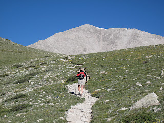
Mount Princeton
On the way to Princeton
elevation gained: 5,234 feet

So we're on the summit of Mt. Princeton and a Search and Rescue helicopter is circling the skies above us, looking for a fallen climber....

Our day climbing Mt. Princeton, Prince of the Sawatch, began with dark omens. We spent the night huddled in our tent as  rain played our tent like a drum. Loud enough, even, to drown the pops and crashes of Buena Vista's Independence Day firework celebration. We lay hoping that the seams of our tent and the various, pre-departure treatments of Camp Dry would hold.

We set an early alarm, 4:30 am, since Princeton, with 6,000' of topographical prominence from Buena Vista, is one of the longest and most-strenuous climbs in all the Sawatch Range. Needless to say when we brought ourselves from the tent neither of us had had a worthy night's sleep. The air was crisp and the nearby mountains were frosted with a light coat of fresh, July snow. All the signs seemed to point towards a poor day for a climb. But the skies had cleared, and though we both struggled with the 4 am witching-hour blues, we had motivation enough to make our way to Princeton's popular trailhead even as the first rays of the morning sun crept above the eastern horizon.

Trailhead: Princeton's trailhead is a lowly 8,900', leaving almost 5,300 vertical feet for us to ascend. We'd hoped to abridge this grueling approach by driving up the Mt. Princeton Road (which serves as the first part of the trail) to a set of radio towers located at 10,800'. Gerry Roach's guidebook, Colorado's Fourteeners (the bible of Colorado fourteenering), offered this sage advice on this trailhead/approach: "There is a large parking lot at the bottom of the Mt. Princeton Road at 8,900'. If you value your vehicle, park here; this is the trailhead". We'd harbored a sincere hope that this advice was perhaps a bit outdated and overzealous, but once we reached this parking lot we discovered a large amount of cars and trucks, many with higher clearance than our humble Subaru, already parked, so we brought our car to a halt alongside them, tightened our bootstraps, and began the long, long, ascent. (We would later discover that most of these cars were not parked here by climbers but by attendees of a nearby dude ranch).

The beginning of the Mt. Princeton Rd. and our trailhead
The bummer of this base-assault technique on Princeton is that the approach becomes a 4.5 mile slog up a moderately busy 4WD road. Road approaches on mountains have never been my favorite. Four-wheelers, dirt bikes, and Jeeps kicking up choking clouds of dust makes for a mood-killing morning.
As we hiked up this relentless road we were passed by many climbers (cheaters) blasting with their trucks and SUVs up the side of the mountain. I came to look upon these people with contempt, claiming to myself that we were here to climb the mountain, not drive up it. It is more likely, however, that I was merely envious of the several miles of tough hiking that they were spared.

Route to Princeton
The road-approach to Princeton
At 11,800' "Tigger Peak" (a 13,300' companion peak of Princeton's) loomed above us, and the route steered away from the long road at last. No more cars, trucks, or "cheaters". Only a switchback or two later, mighty Princeton appeared on the horizon. It was clear from this first vantage that Princeton truly is a monarch and a powerful peak.

Not much farther, at 12,300', the rest of the route opened before us. Though it did not look far, it was a deceptively long, arduous climb to the top.
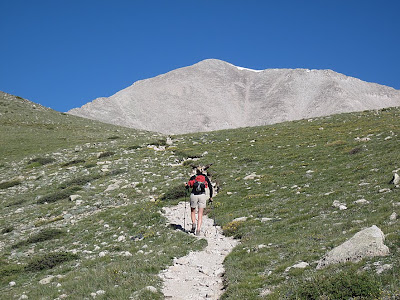
Trail to Princeton
Mt. Princeton in view at last
The last mile and a half required careful, tedious route-finding through large boulders and loose talus. Concentration was mandatory with each step to avoid a slip. Above 13,000' the route became very steep and the boot-worn trail was analogous to a precipitous slip-and-slide of gravel ball-bearings. I often found myself frequently employing all four limbs for greater purchase.

Starting to feel the benefits of having climbed nine mountains already this summer, however, we caught and eventually surpassed most of the climbers that had driven past us earlier that morning.

The last section of Mount Princeton
Mt. Princeton from around 13,000 feet
Four and a half grueling hours after leaving the car behind at the trailhead, we were on Princeton's dramatic summit sharing congratulations with other climbers. One climber loudly claimed Princeton as his "21st fourteener". He added to this voluminous boasting his opinion that "all the mountains looked the same". The Prince was my 14th fourteener, and I couldn't disagree more. I found myself resenting his brand of high-alpine cynicism. Each mountain to me is as unique as the climbers who climb them. He refused to smile when we took his summit photo for him.

View northwest from the summit of Mt. Princeton
View to the northwest from the top
(Mt. Harvard on the right in the distance, Mt. Yale in the center)
So back to the Search and Rescue helicopter...

Word reached the summit, passed along the climbing chain, that somebody had fallen on the mountain. Almost as soon as we heard this disturbing news, a bright-orange Search and Rescue helicopter appeared and proceeded to circle the mountain for most of the remaining day. We could see the entire difficult portion of the climb from the top, and nobody appeared to be injured or in distress of any sort. As we descended we ascertained from other climbers still on their way to the top that a woman was claiming that her daughter had fallen. With understandable panic (had this actually been the case) she had summoned Search and Rescue to the mountain she thought she was climbing: Mt. Princeton. Unfortunately for everyone involved, she had made a major miscalculation and had actually been climbing "Tigger Peak" (Princeton's aforementioned companion mountain).
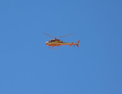
Rescue Helicopter on Mt. Princeton
The Rescue chopper dizzily circling overhead
By the time we reached the bottom we had learned the full story: in the process of ascending the wrong peak, mother and daughter had somehow become separated. Panicked, the mother had summoned Search and Rescue. Nobody had ever fallen. Nobody had ever been hurt.

My conclusion from this strange event was that many people climb 14ers who do not take these mountains seriously enough. First of all, nobody should climb a 14er if they haven't done enough research to avoid ending up on the wrong mountain. Proper studying of topo maps and the numerous available guidebooks would have made such a miscalculation almost impossible. Secondly, Search and Rescue should not have been summoned unless there had been, without a doubt, an accident. Ambulances, Sheriffs, a helicopter, and a Chaffee County Search and Rescue team a half-dozen members strong spent the better part of a day searching for a climber who was never in trouble in the first place. These hard-working folk might have had an actual emergency to attend to. This false rescue was a clear waste of resources. Though I was glad, of course, that nobody was injured, I was secretly satisfied with the knowledge that the mother-who-cried-wolf was likely stuck with a $10,000 bill for her mistake.

Visit THE ARCHIVE: A list of most of our articles sorted by department

find us on facebook

Copyright notice: This website and all its contents are the intellectual property of www.coloradomountaineering.com and its authors. None of the content can be used or reproduced without the approval of www.coloradomountaineering.com.

Climbing and mountaineering are dangerous!! Please see the DISCLAIMER page
For information about how to contact us, visit this link