Friday, February 22, 2013

PEAK OF THE WEEK: Quandary Peak

INTRO
Quandary Peak
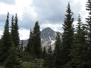
Quandary Peak from Highway 9
Quandary Peak has a reputation as one of Colorado's easiest and most accessible 14ers. It is a relatively short and straightforward ascent, which makes it popular as a first fourteener or as a winter ascent. Its location just a few miles away from Breckenridge off I-70 also increase the amount of traffic this mountain sees. Despite Quandary's reputation as an accessible and simple mountaineering destination, it also offers some hidden challenges for alpinists who desire more than just a easy class 1 trail hike. Several routes on the mountains north and west sides are far more engaging than the pedestrian standard route up the East Slopes (Quandary Peak Trail). The West Ridge offers a class 3 scramble (though on dangerously loose rock), the Cristo Couloir is a short and engaging snow climb on the peak's south slopes, and the Inwood Arete provides a technical rock climb on Quandary's rugged north face. From casual hikers to winter ascentionisits to rockaneers, Quandary has a little something for everyone.

DIRECTIONS
Snow on Quandary Peak at 14,000'
Near 14,000' on Quandary's East Slopes
From downtown Breckenridge take Highway 9 south towards Hoosier Pass. After 8 miles, locate a small dirt road (CR 850) about two miles short of Hoosier Pass's summit. Very quickly you will find McCullough Gulch Road (CR 851) on the right. Take this road. The Quandary Peak trailhead is just a short distance up this road on the right. To reach the snow couloirs on the peak's north side and the West Ridge route, forgo the turn onto McCullough Gulch and continue 2 miles along CR 850 to the Blue Lake trailhead at the base of a dam. To reach the South Face and Inwood Arete, continue on CR 851 for a couple of miles until you reach a locked gate.

ROUTES
East Slopes (standard)
The standard East Slopes route on Quandary Peak is one of the easiest and most popular routes on a Colorado 14er. A good trail takes you all the way to the summit. From the trailhead, follow the well-defined trail as it winds through the forest for a few miles to treeline at 11,500'. Downed lumber can sometimes impede your progress in this section but shouldn't be too much of an issue. From treeline continue up the trail along a rounded ridgeline to a flat section at 13,100'. From here the angle steepens. Switchback up the final 1,000' to Quandary's excellent summit.

Cristo Couloir
This snow couloir is short and straightforward. From the Blue Lake trailhead, locate the couloir. It is the most apparent and leftmost of three climbable couloirs on Quandary's South Face. The couloir is short, just barely over a mile, but ascends 2,500', so be ready for some steep climbing. Avalanches are a strong possibility, so carefully consider the snow conditions before beginning. This route is an unpleasant scree mess when the snow has melted out.

Inwood Arete
Snow on Quandary Peak in Colorado
The final push to the summit of Quandary
This technical alpine route is an interesting way to make more of a challenge out of a mountain that has a reputation for being easy. From the trailhead hike along a climber's trail to a lake near 12,000'. The arete begins here. You can do a direct start at 5.6-5.7 or head east to an easier 5.4 start. Climb mostly 5.easy climbing past some towers (do not climb the towers) until you are deposited on easier terrain (still class 3 and 4) above somewhere around 13,500'. Expect runnouts, loose rock, and some tricky routefinding on this route.


TRIP REPORTS
Quandary Peak: Late Spring in the Colorado Mountains
An account of a successful ascent of the East Slopes route of Quandary in June 2010. With heavy snow still on the trail, the route was considerably more difficult than when it is dry in summer.

LINKS
Inwood Arete on Summitpost.org
Inwood Arete on mountainproject.com

Visit THE ARCHIVE: A list of most of our articles sorted by department

find us on facebook

Follow us on Twitter!

Copyright notice: This website and all its contents are the intellectual property of www.coloradomountaineering.com and its authors. None of the content can be used or reproduced without the approval of www.coloradomountaineering.com.

Climbing and mountaineering are dangerous!! Please see the DISCLAIMER page
For information about how to contact us, visit this link


Wednesday, February 13, 2013

Hanging Lake: Gem of the White River National Forest

INTRODUCTION

Hanging Lake, Glenwood Canyon
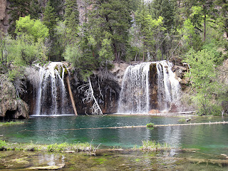
Hanging Lake in summer
This ultra-popular hike is in Glenwood Canyon east of Glenwood Springs. The trail ascends 1,200’ in about a mile and a half from the Hanging Lake Trailhead to the teal-blue waters of Hanging Lake. A series of beautiful waterfalls at the top makes this a worthwhile adventure. This hike draws a great deal of attention, particularly on summer weekends. For more solitude, hike Hanging Lake in the off-season such as fall when the air temps are not as high, the crowds are down, and the colors are out. The trail up Hanging Lake is solid and well-maintained. Despite this, many people underestimate the effort required on the steep route that leads back to the lake. For the experienced hiker, however, Hanging Lake is little more than a moderate workout in a gorgeous setting.

GETTING THERE
From Glenwood Springs, drive east on I-70 nine miles to the Hanging Lake exit (exit 125). This exit is only accessible from the eastbound lanes, so drivers coming from the east will have to exit and turn around at exit 121 (Grizzly Creek) to get there. Park at the large rest stop (which will fill despite its size on a busy summer weekend) and hike .5 mile east along the Glenwood Canyon Bike Path to reach the trailhead.

Winter in Glenwood Canyon
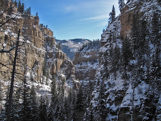
Hanging Lake Canyon in winter
THE ROUTE

While this hike is on a solid trail the entire way, it is important to note that it is strenuous. Many people undertake this hike thinking that it's going to be a casual journey; it is not. You will probably pass many un-shapely humanoids struggling and complaining their way up this trail. For a true hiking enthusiast, however, making it to the lake shouldn’t be a problem.

The trail follows Deadhorse Creek up the northern side of Glenwood Canyon, passing many rapids and waterfalls along the way. There are several footbridges and plenty of shady places to stop and rest. The trail becomes considerably steeper near the end as you circumnavigate Bridal Veil Falls just below Hanging Lake proper. The very last pitch is the steepest, and steps have been cut into the stone to help you along. In addition, a handrail has been constructed for protection. Despite these safety features, it seems like several people get injured up here every year.


Spouting Rock
Spouting Rock above Hanging Lake
Once past the steepest section you arrive at Hanging Lake. Here a beautiful, multi-ribbon, 40’ waterfall pours into a teal-green pool formed by travertine “teacup” deposits. This travertine is very fragile and takes eons to form. To protect this fragile wonder, a wooden walkway has been constructed around the lake. Please be respectful of this amazing place and stay on the boardwalk.

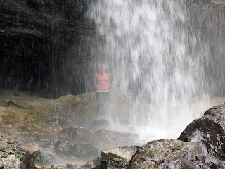
For those seeking a little adventure, a spur trail climbs up and around the main waterfall to Spouting Rock, a peculiar waterfall which partially erupts directly from the cliff. You can walk behind the waterfall here for a unique perspective and even stand under it if the water is low enough. Take caution, however, this plunge generates some powerful forces!

CAMPING
The nearest camping is at the Glenwood Canyon Resort off the No Name Exit in Glenwood Canyon (a few miles west of Hanging Lake). Here you will find cabins, showers, and slightly overpriced tent sites.

Hanging Lake in winter
Spouting Rock
Winter at Spouting Rock
Visit THE ARCHIVE: A list of most of our articles sorted by department
find us on facebook

Copyright notice: This website and all its contents are the intellectual property of www.coloradomountaineering.com and its authors. None of the content can be used or reproduced without the approval of www.coloradomountaineering.com.

Climbing and mountaineering are dangerous!! Please see the DISCLAIMER page
For information about how to contact us, visit this link


Thursday, February 7, 2013

FEATURED ROUTE: The North Ridge of Mount of the Holy Cross

STANDARD ROUTE (NORTH RIDGE OF MOUNT OF THE HOLY CROSS)

Length: 11 miles (roundtrip)
Total Elevation gain: 5,800'
trail access: Half Moon Trail

Mount of the Holy Cross
The North Ridge of Holy Cross is one of Colorado's best class 2 adventures. It is an amazing and challenging climb that takes you to one of Colorado's hallowed places. The length and total elevation required for this climb necessitate a two-day outing for many people. This might be advised for anyone whose conditioning might not be up for a one-day approach. That trade off, however, is that you will have to lug a heavy backpack over Half Moon Pass twice. Is it easier? The more environmental choice is to minimize your impact by climbing Holy Cross in one day. However, this is a place that warrants a slow, contemplative pace. I recommend a backpack of at least two days. Three might be preferable. Take your time and enjoy this beautiful wilderness. Please minimize your impact by adhering to No Trace Wilderness ethic.

From Half Moon Trailhead, follow Half Moon Trail for 2 miles to Half Moon Pass at 11,600'. On my last trip, I discovered crossing this pass can be exciting in an afternoon thunderstorm. After summitting Half Moon Pass, descend gradually at first towards East Cross Creek. You will soon get your first views of the North Face of Holy Cross, an impressive sight. Soon the trail starts to descend more steeply and you round a corner and get an amazing view of the mountain and the East Cross Creek Basin, complete with steep granite walls on the basin's north flank, the mountain to the south, and a tallish waterfall in the center. You know now if you didnt before that this is a special place. Descend another 900 feet into the creek basin where some excellent campsites exist near the creek. Stay in one of the numbered campsites to minimize impact. You can be ticketed by rangers for camping elsewhere. Not only is it a legal issue anyway, it is environmental, so please respect this.

The Gore Range in Colorado at sunrise
The Gore Range in the distance from the North Ridge
Cross East Cross Creek at a makeshift rock bridge and follow the trail as it winds up the northern slopes into the high alpine zone. At around 11,500' you will cross treeline. A bit later you will get your first glimpse of the mountain, much closer and even more imposing now. Follow the trail as the ridge tightens to a prominent notch at 13,700'. you can peer down the inset couloir, which is impressive whether it has snow or not. From here the trail gets rougher. Pick your way through class 2 to 2+ terrain to an impressive summit.

Do not get lost on the descent! Remember the route. Going too far west or north of the trail can pull you into the Cross Creek drainage (not the East Cross Creek drainage where you want to be.) While there are trails there, they will take you very far away from your vehicle. Also don't forget you have to go up and over (1,000') Half Moon Pass on the way out. As aforementioned, this can be exciting if the afternoon storms are rolling in and exhausting anytime after a long climb of Holy Cross.

TRIP REPORTS

Longs, Holy Cross, and McGregor Mountain

Frustration in Paradise

Visit THE ARCHIVE: A list of most of our articles sorted by department
find us on facebook


Copyright notice: This website and all its contents are the intellectual property of www.coloradomountaineering.com and its authors. None of the content can be used or reproduced without the approval of www.coloradomountaineering.com.

Climbing and mountaineering are dangerous!! Please see the DISCLAIMER page
For information about how to contact us, visit this link


Monday, February 4, 2013

5.9 Ain't What it Once Was: An Exploration of Grade Inflation in the Yosemite Decimal System

The Yosemite Decimal System is a complicated entity fully worthy of dissertation-like exploration. But the YDS is an empirical system not a intellectual one, and any attempt to reduce it to research and discussion is bound to be flawed. If you are new to the Yosemite Decimal System, a good place to start is our article from January 2012 that provides a basic understanding of its history and of its general grade ratings.

A 5.10a rock climb in Western Colorado
A 5.10a sport climb in Colorado
There is much discussion, particularly between the older and younger generations, about a particular YDS phenomenon in the climbing and alpine world often called grade inflation. I work occasionally as a route setter at a local climbing wall. After designing and executing a project I was sure (and was confirmed by three other climbing friends, all of which can onsight 5.10 and one of which who can onsight 5.12) was 5.10b/c, a climber that was 48 years old and has several decades of climbing experience suggested 5.9+ as the rating. Surprised by this, I voiced my doubt and had him try another climb nearby which I originally rated 5.11a but after a few ascents downgraded to 5.10d. Again, this was confirmed by the same three friends. After struggling a bit but finishing the climb, this 48 year old climber suggested once again that this climb was 5.9+, only adding this time that it was "maybe" 5.10a. I was shocked, and this time I protested saying that this rating was simply impossible. After a lengthy discussion, at best I could convince him that it was at least 5.10b but he would concede no higher. While I was thinking "sandbagger," he suggested perhaps the difference was due to "a different generation" in a smug tone I interpreted as elitist.

While this encounter is not proof of anything other than the subjective nature of any grading scale in general and the Yosemite Decimal System here in particular, it got me wondering about the familiar theory of grade inflation all over again. Does it exist and why? Visit beta websites that allow users to vote for "consensus" ratings on routes such as Kor-Ingalls on Castleton Tower or The Mace near Sedona, Arizona that were established several decades ago or more and you often find that the new consensus is higher, sometimes considerably, than the original suggested rating. Is it that modern climbers, influenced by the safety of clip and go sport climbing, have been softened by the loss of "boldness" from the mainstream climbing realm? Or that many climbers climb for years and never learn to place a cam or a piton?

True Grit (5.8) a sport climb in Unaweep Canyon, Western Colorado
While considering this question, my research took me to a broad spectrum of places. In order to understand the issue of grade inflation, it seemed vital to understand its history. As noted in our history article, the YDS scale was invented at Tahquitz Rock as an extension of the Sierra Club's terrain rating scale that was used to grade alpine routes of all levels (class 1 being trail walking and class 5 being technical climbing). Ratings were established from 5.0 (easiest technical climb) to 5.9 (hardest technical climb at the time). The climbs at Tahquitz Rock, therefore, became the baseline routes by which all others would be compared. However, when you review the history of the rating at Tahquitz, you find a peculiar thing: the original ratings, the ones that were supposedly designed to anchor the entire system, have migrated slowly and steadily upward.

White Maiden's Walkaway on Tahquitz Rock's Maiden Buttress is an 800 foot multipitch trad route that was established in 1937 as one of the baseline routes at the 5.1 rating. Subsequent guidebooks over the years show that the rating has slowly risen to 5.3 then 5.4 and now some guidebooks list it 5.5. A survey of the consensus votes on one popular beta website reveals that one quarter of the climbers suggesting 5.6. Has the scale really bumped five number grades? Would that mean that modern 5.15 is simply what 5.10 was in 1937? The short answer is yes... and no.

The truth is the scale has inflated. As it has been refined, the higher grades have become more important and useful by modern standards. After all, many climbers today will lead their first climb at 5.6 or 5.7. The difference between 5.0 and 5.2 is almost indistinguishable. In truth, everything from 5.0 to 5.4 is a vague blur and often seems to overlap with class 4. In the days before the scale was opened to the mathematically illogical 5.10 rating (subverting the notion that class 6 climbing was aid climbing) in the early 1960's, when a climber encountered a climb that was at the very limit of the time it had to be rated 5.9. Sometimes the most devious of these would get a feeble 5.9+ modifier. That's not to say all 5.9's were the same, they just had no other rating to apply to these cutting edge climbs. When the scale finally opened, it was ultimately refined and slowly expanded as the sport advanced.

Today, the YDS and other scales are continuing to expand together. The YDS and the French scale, for example, have locked in step progressing at identical increments as a small group of international climbers establishes and confirms new futuristic climbs. As the grades expand slowly, one letter increment at a time, and benchmark routes are established at the new grades, the scale(s) have become more refined than in the older days. The aforementioned grade inflation does not seem to occur at these higher grades, and certain routes that have been held up as examples of certain grades have rarely changed over the years. If anything they tend to get downgraded as the beta develops and more ascents are made.

grade inflation in the YDS system for grading rock climbs
The author on a 5.12 (or is it 5.9+?)
sport climb in western Colorado
What all of this seems to mean is that modern climbers are not soft compared to their predecessors, despite the explosion of popularity in the safer mode of sport climbing. What the sport climbing explosion has allowed for is climbers to focus on pure difficulty, and people are sending routes that those who established the YDS scale could never have imagined 80 years ago. While the lower end of the scale might be softer than it was decades ago, the upper end of the scale has now been pushed higher than ever in all aspects of the sport, not just in bolt protected sport climbing. The so-called world's hardest off-width, The Century Crack (5.14b), was free climbed in Canyonlands National Park in Utah in 2011, as well as the hardest trad line in famed Indian Creek: Carbondale Short Bus (5.14- PG-13). Bold alpine first ascents have occurred in the Ruth Gorge in Alaska and elsewhere across the world. Alex Honnold soloed Half Dome, El Cap, and Mt. Watkins in a single day. While the sport has gone mainstream and become safer in many ways, boldness is still very much alive and rewarded. Though grade inflation has occurred notably over the decades in the lower grades, the higher grades have remained relatively stable, only expanding as new generations are able to push the sport further and further into the future.

Visit THE ARCHIVE: A list of most of our articles sorted by department

find us on facebook

Copyright notice: This website and all its contents are the intellectual property of www.coloradomountaineering.com and its authors. None of the content can be used or reproduced without the approval of www.coloradomountaineering.com.

Climbing and mountaineering are dangerous!! Please see the DISCLAIMER page
For information about how to contact us, visit this link