Sunday, July 28, 2013

Dirty (Wet) 30 or A Journal Account of Five Rainy Days in the San Juans

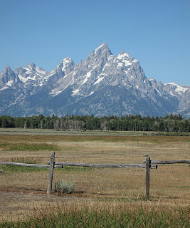
Vestal Peak and Arrow Peak
Vestal Peak (left) and Arrow Peak (right)
Turning 30 isn't a bad thing. Of course not. It is something to celebrate. So how should I celebrate mine? Climbing Wham Ridge on Vestal Peak in the Grenadier Range of the San Juans sounds about right. Wham Ridge was one of my dream climbs, and one of the most important routes on my fiancee and I's personal summit list. Coordinating our time off from work, we had a week-long shot at a destination that had been on our radar for some time.

As it would turn out, June of 2013 was one of the driest months on record. My hometown of Glenwood Springs, which is located at 5,700 feet and sandwiched in-between the Elk Mountains to the south and the Flat Top Mountains to the north, received precisely zero measurable precipitation during the month, and though the San Juans fared slightly better, hardly anyone could remember so many bluebird days on top of each other. As our luck would have it, a few days before our trip was set to begin, a peculiar, backwards-moving (east to west) low pressure system drew moist, Gulf air directly over the state of Colorado, and our long dry-spell was quickly brought to an end. There were flash floods in Grand Junction, and rain and lightning all-across the state. We knew, watching the forecast as the days of our trip appeared on the extended outlook, what we were likely in for.

DAY 0
So here we are... Today is my birthday. My 30th birthday. And my fiancee, Ella, and I are are camped at Molas Pass awaiting morning so we can begin our backpack trip into the Grenadier Range. It is raining, hard. I get the feeling this is something we will have to get used to.
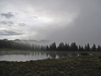
Little Molas Lake in the fog
Little Molas Lake
Today was a travel day but not without some fun and excitement. The rain started not long after we arrived, lasting 30 minutes or so. After that, we were able to take a short walk around the lake. The fog was tremendous, and we captured some amazing photos in the storm's aftermath. When the rain threatened again, we made the 5-mile trip to Silverton where we ate pizza and strolled down Main Street examining the shops and galleries. When we returned to camp, the rain returned. It is even harder and more sustained this time. I don't think it would feel harder against our tent if someone were spraying it with hose.

DAY 1
It was foggy this morning, and damn cold. We made breakfast, took down our tent and packed up our bags before 8:30 am. Hardly anything could be seen through the fog as we drove down to the trailhead, wished our car goodbye and got to it.

Fog over the San Juans
Heavy fog and rain ahead...
The whole day we were chased by sprinkles and the darker threat of rain. However, we were able to make it to camp at 9,900 feet at the "Beaver Ponds" without getting too wet. At least there was NO THUNDER!

The Beaver Ponds are a small series of, well, beaver ponds located at the turn for Vestal Basin. To start our day, we had to descend 1,800 feet from the 10,700-foot Molas Pass trailhead to 8,900 feet at the Animas River, then re-climb 1,000 feet to get here. With the added weight of the climbing gear it had felt horrific near the end.

A moose came strolling into camp earlier.Came up the trail and walked right past us before settling in at the Beaver Pond, where she fed on moss and drank the water for over an hour. At first I was intimidated, being
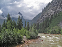
The Animas River in the San Juans
The Animas River (8,900')
so close. But after staring us down, she seemed to decide we weren't a threat. After that we co-existed without concern, even pumping water not fifty feet from where she drank.

We have found a beautiful place here, though some of it has been concealed by this stubborn fog. Who knows what we will be able to see in the coming days. Will we be able to climb Wham? Will it stay socked in with weather? Will there be wildlife and amazing scenery? I am anxious to find out.

DAY 2
After a good, maybe overly long night of sleep, we awoke to another foggy, overcast morning. At first, the dramatic aiguilles of Arrow and Vestal were partially visible through the billowing fog. Soon, however, they vanished once again completely behind a veil of white clouds.

Arrow Peak and Vestal Peak
Arrow Peak (right) and Vestal Peak (left) from camp
We decided to use the day to rest and recover our tired bodies. We figure we can still climb Wham tomorrow using this campsite as a basecamp. After all, we are at 10,200 feet [note: This was a mistake. We were actually at 9,900'] and it's only 3,600 feet to the summit, a comparatively modest amount. Regardless, it will still be a long day tomorrow.

It is hard to say what the weather will be like. Today it is unsettled, though with a seemingly low chance of rain.

After going for a three-mile hike and taking an hour nap, the weather has cleared somewhat and is now about the nicest we have seen. Large patches of blue sky have come to accompany about half the heavens, and it seems possible that, as each day has been minorly better than the last,  tomorrow could prove to be a good day for a shot at the summit.
Arrow Peak in the Fog
Arrow Peak coming out of the fog

Just talked to a group who attempted Wham today and were not able to get very far. As Ella and I have been saying, just being back here has been treat enough to make this trip more than worthwhile, even if the flies are getting bad. Still nothing could compare to the nightmare situation with mosquitoes two years ago in Wyoming.

This evening the rain came back, coming down off and on for several hours. At times it was light enough that we were able to sitting under the protective needles of a tall pine by the lake, hardly feeling even a drop. We watched the rain patterns on the lake surface, and the fog rolling up and down on the hillside. Despite everything being so damp, it was calm and mild.
Red flowers
The storms are coming in from the wrong way. It took me awhile to figure this out but storms have been moving in very slowly from the northeast. They are moving so slowly, however, almost imperceptibly, that it is hard at time to see them move at all. A weather system must be sitting directly over the mountains. Though it means these storms are long, damp and protracted, it also seems that they have no energy and therefore no real lightning. At least, not yet....

DAY 3
Certainly the most interesting day yet. We woke around 5 a.m. after a rather pitiful night's sleep. I couldn't rouse myself for an attempt at Wham. When we awoke fully a few hours later, there was not a cloud in the sky. This made me a bit upset.

To see Arrow and Vestal bathed in sunlight, beckoning with its beautiful, quartzite north face was almost enough to make me want to cry with disappointment. I had wanted to do this climb for so many years and here I was within touching distance and the only thing that kept me off of it was myself.

This severe disappointment was enough to prompt us to pack up and move basecamp up into Vestal Basin for a chance tomorrow. Looking back now from day's end, the jury is still out on whether that was a mistake.
ducking under a log with backpack
Ducking logs was the norm
en route to Vestal Basin. Hard with
a 65-pound pack

Though the hike was short and gained only about 1,500 vertical feet, it was perhaps the most grueling day of backpacking i have experienced. The "trail" was in bad shape with countless logs to duck under and climb around. With a fully stocked pack, this took a lot of energy. It was steep, loose, overgrown and very frustrating. Of course, we also got off, in one point, on the wrong path and had to battle up a steep scree gully.

Then there was the storm....

Almost immediately upon reaching Vestal Basin, the rain began. We were beat, barely able to carry our packs another foot. We picked a campsite and set-up hastily, noting the evidence that our tentsite had recently had water running through it. We built a levee against the possibility that it would happen again.

The rain/hail/lightning came, our worst storm yet. Some violent lightning for a solid hour, with never more that 10 seconds between rumbles of thunder. It did, however, seem like most of the lightning was cloud-to-cloud. The occasional ground strike really gets your attention when you are at 11,500 feet in a broad meadow with only sparse trees for protection.

Vestal Peak in the rain
Vestal peak at last, but in the rain....
Our levee failed somehow and water seeped in from the bottom of the tent. It was Geneva Lake all over again (we experienced by far the scariest lightning storm of my life in 2010 there and it lasted literally all night). The thought of having to endure another night like that was almost too much to bear. I found myself longing, for the first time really, for the safety of civilization.

But now the storm has passed and the weather has stabilized. We have realized that the possibility of doing Wham tomorrow is almost impossible. We are simply too low on energy now, too waterlogged, and the weather is too unstable for such a long committing climb. It just seems like it wasnt the right week for an attempt. To matters less appealing, we have a long hike out capped by an 1,800 foot slog out at the very end. At least, I try to convince myself, that part of the trail wont be as unstable as what we did today.

Backpacking is rugged, that is the bottom line. Especially with a full, alpine rack weighing you down from the dark depths of your pack. Type two fun for the vast majority of the time.But it is always good for the soul, and later the pack seems less heavy and the rain storms less soggy when time softens the memories. There is no doubt, however, that at times backpacking is trying and even scary on occasion. Those moments help me appreciate the comforts of home. Maybe in some ways that is the main reason why we come here.

Despite the hardships, this is one hell of a place. One of the most spectacular basins I have visited in Colorado, really. We are at the very toe of Arrow Peak, and earlier had a perfect view of Wham. While it seems that we wont get to climb, those views alone were worth the trip.

DAY 4
Having fun with the Grenadiers
Ella has some fun with Wham
Crazy day! After waking to another beautiful morning, we hiked up to get one more good look at Wham, taking some goofy photos in the process. We might as well have fun with the mountain since we weren't able to climb it.

Next it was time to head down Hell Hill, which earned its moniker today even more than yesterday. Not far into the hike, I sat down to wait for Ella, who I'd gotten ahead of while she was taking pictures of flowers in a field by the creek just behind me. After about fifteen minutes I started getting impatient, whistling and calling out.Frustrated now, I shrugged off my pack and stomped back to look for her. But she had vanished.

Panic ensued. For the next half an hour at least I was running back and forth up and down the trail yelling her name. I couldn't fathom what had happened. After running back and forth three times, the third time going almost all the way back to the turn for camp, I was thoroughly exhausted and decided the only possibility was that she had somehow gotten ahead of me. But how could she get off on the wrong trail like that?

Putting my pack on, I started down the trail only to realize that it was me who had gotten off trail. A little dead end spur, the real trail switchbacking higher up the hill and an almost imperceptibly junction. I was once again fooled by the un-maintained trail.

Wham Ridge
Wham Ridge in rare sun
Ella and I made a happy reunion at the bottom where she had frantically been running up and down the hill searching for me. We rested and ate lunch at the lake to recover from the ordeal. We felt exhausted now, but had made the goal to a reach a campsite by the Animas River where we had eaten lunch on Day 1. If we made it there, all that stood between us and the car (and a big meal in Silverton) was that last hill. After a half our at the Beaver Pond, we shouldered our packs once again and stumbled down the long hill.

My ankle was hurting now, after the second even-more-gnarly battle with Hell Hill, and I had to shift my stride to keep from further aggravating it. I took an ibuprofen, something I almost never do, to ease the journey.

The weather was still mostly nice when we reached the Animas. Storms were rumbling over the basin we had left but the low valley was sunny and hot. We spread out all of our clothes and tarps and rain gear to dry for the first time in days.
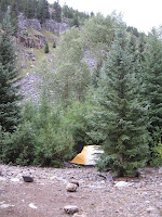
Animas River camp
Animas camp last night
Not willing to pump from the silty, heavy-metal-looking waters of the Animas, we walked a short distance to Molas Creek to fill our empty water bottles. Our pump was starting to move slow, and it took us a good half hour to get half way through. About the time it was my second turn, I felt the first splashes of raindrops. I cursed myself for not bringing my rain pants, but tightened my rain jacket around me and kept pumping. It started to rain a little harder so we took a break under a tree that was mostly keeping us dry.

"We should move," I said to Ella. "We will just get soaked out here and who knows how long it is going to last. Ella agreed and we started heading back to the tent. That was when it started really coming down. None of the "T word," but just hard, slamming rain. By the time we got back to the tent we were drenched and muddy. To make matters worse, the bottom of the tent had flooded once again.

After using the vestibule to attempt to separate what was dry with what was muddy, we used an old t-shirt to dry off the floor as much as possible. Now we were soaked again, almost everything we had was completely drenched. And the rain came down, pinning us inside that tiny, bright-yellow "shelter." We played a game of travel chess, which ended in a tie as the storm built around us. The lightning started after about a half hour. Spread out but all close ground strikes within five seconds, flash-to-bang (i.e. less than one mile).

footbridge over the Animas River
Footbridge over the Animas River
It was the longest, most sustained storm yet, lasting for well over two hours. Finally it tapered off and we were able to go outside in the soggy campsite and feed our hungry bellies. We ate mashed potatoes and gravy then followed that with mac and cheese, eating our extra meal for the hell of it. What a feast it seemed like. For perhaps the first time in what has turned out to be a surprisingly grueling backpack trip, I feel full!

So now I sit here beside the murky Animas, a river I have long dreamed of kayaking I might add as an aside, writing as night closes in. Tomorrow we will make the long hike out. I am both glad, as rain and thunder and a 70-pound pack have begun to take their toll, but also a bit sad.

For now I will make the most of what we have left. Tomorrow we might be out of the wild but we will still be on vacation. We have earned a few indulgences!

DAY 5
We have escaped. An escape is what it feel like indeed. Battered, tired, hungry, limping, we stumbled out of the Weminuche humbled by our experience. We woke up in the morning to nice weather. We took down camp with some extra excitement, knowing that we were going to get to sleep in a bed and eat a big meal today.

The Animas River crossing
The Animas crossing on Day 5
The hike out was long and difficult. Though the trail was solid, the hill was relentless. It did not take long to climb the 2.5 miles and 1,800 feet of elevation gain, but by the time we got to the top we were exhausted. A week's worth of difficult journeys had begun to take their toll. After taking the wrong trail at the last fork not half a mile from the end, we were forced to hike almost a half mile of unnecessary terrain. I collapsed next to the car when we reached it at last. We came time to unlock, however, I made two simultaneous, alarming discoveries: the car was unlocked and the the electronic door look didn't work. This of course meant only one thing, dead battery.

It seemed fitting to end the trip this way. Maybe our adventure wasn't quite over.

Luckily, we were able to flag down a group from Virginia off the highway who, after myriad advice about car maintenance, were able to get my engine to turn over and start. We were in Silverton ten minutes later, feeling famished. Out of the wild.

Staying now at a cabin in Durango, there is time to reflect on our trip and why we were unsuccessful in making our summit(s). If there was a failure, it was in not moving our camp from the Beaver Ponds at 9,900 feet and into Vestal Basin at 11,500 feet on day two. It was a hard decision to make, as the basin was sock in with fog and rain for nearly the entire day. Had we moved camp through what turned out to be almost an entire day of rain and lightning we would have been in position to capitalize on the weather window on Thursday (day three) morning. Our decision to try to climb Vestal from the Beaver Ponds was foolhardy, as Hell Hill turned out to be proved quite the challenge. But we abandoned this idea at 5:00 am after hours of rain the night before.
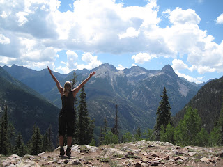
Mountain Pose in the San Juans
Mountain pose at the end
But everything had looked so perfect on Thursday morning, we had to try for Friday. So we lugged all of our crap up Hell Hill. And we got wet.... Oh yes. A massive hailstorm almost immediately after setting up the tent (a theme for the week, it happened three times that rain came within 15 minutes of setting up our tent. The floor breached for some reason, and 90% of our stuff got wet. After enduring that hail/thunderstorm, we were just about spent. Any question of attempting the peak was basically answered.

On Friday there was a window and we were in perfect position, but we also knew we had to start making our way out of there, and it was a long journey. Ultimately, the worst storm of the week moved in by 3 pm on Friday.

At least know we know the land, and we will be much more prepared the next time we come here. I have concluded we should do a few things different.

1) Take the train. The $85 would have been worth it, as that first 1,800 foot hill was a major drain on energy and resources. It adds 6.5 miles and a lot of elevation to the journey.

2) Get into Vestal Basin as quick as possible. While the Beaver Ponds were a pleasant place to linger, getting Hell Hill over and behind early in the trip rather than later would have been helpful. A one-day shot from the Beaver Ponds is ambitious at best.

3)Perhaps go in September when the weather is more stable. Even the windows to climb that did exist were short for such a long, committing route.

4)Be better conditioned! My body did not react well to the ultra-heavy pack.

Oh well, we had fun and had a challenging experience. We are out now and already civilization is back to its mundane familiarity. But I am glad not to be cowering in the tent from a storm. I feel good and will leave with my head high. It was overall a positive experience.

Visit THE ARCHIVE: A list of most of our articles sorted by department

find us on facebook

Copyright notice: This website and all its contents are the intellectual property of www.coloradomountaineering.com and its authors. None of the content can be used or reproduced without the approval of www.coloradomountaineering.com.

Climbing and mountaineering are dangerous!! Please see the DISCLAIMER page
For information about how to contact us, visit this link


Sunday, July 21, 2013

NEWS: Climber Dies on Capitol Peak (7/21/13)

The north face of Capitol Peak, sight of
a fatal accident on Saturday
A climber, identified as Ryan Joseph Palmer, 35, from Vail, Colorado, has died on Capitol Peak Friday after attempting to downclimb the north face of the mountain. According to reports, Palmer decided to downclimb the very steep and treacherous north face because he didn't want to return over the exposed ridge known as the Knife Edge. It is unclear if Palmer thought the north face would be an easier alternative to the Knife Edge (it is not), as his companions claim they did not discuss the decision with him. Search and Rescue was able to remove the victim's body on Saturday afternoon despite the rugged terrain and difficult location of the accident.

June and July have been difficult months in the Colorado mountains. Several tragic accidents have occurred, including the deaths of Steve Gladbach on Thunder Pyramid June 23rd, and Howard Scotland III on Jagged Mountain July 11th. Also killed in June and July were Colorado mountaineers Gary Miller, on Grand Teton, and Randy Udall, who was in the Wind River Range.

Visit THE ARCHIVE: A list of most of our articles sorted by department

find us on facebook


Copyright notice: This website and all its contents are the intellectual property of www.coloradomountaineering.com and its authors. None of the content can be used or reproduced without the approval of www.coloradomountaineering.com.

Climbing and mountaineering are dangerous!! Please see the DISCLAIMER page
For information about how to contact us, visit this link


A Grand Adventure: The Four Pass Loop

The Maroon Bells
Maroon Lake at the beginning
The world-famous Maroon Bells were reflected perfectly on the placid surface of Maroon Lake. Every detail rendered in full high-definition, though upside down, in front of us: the twin summit, the rusted-red color, the U-shaped glacial valley frame. Even the cotton-ball clouds high overhead were perfectly visible on the still waters of the lake. We shrugged on our packs, grunting as the weight of seven days worth of clothes, food and gear settled onto our shoulders. Yanking the straps tight, I took one last look at my car. If all went well it would be over a week before we saw it again.

“Woo-hoo!” my fiancée Ella agreed. We paused to take a photo of the classic Maroon Lake vantage, without a doubt one of the most photographed spots in the state. After a few final adjustments to our backpacks and a sip of water, we started up the trail.

The Four Pass Loop is an excellent backcountry route that courses 25 miles through the heart of the Maroon Bells-Snowmass Wilderness Area. Despite the relatively modest length, the Four Pass Loop is a treasure trove of backcountry wonders. As implied by the name, the route crosses over four passes, all between 12,400 and 12,500 feet in elevation.

Going clockwise, we started up the Maroon Creek basin, camping the first night at the base of Maroon Peak not far below treeline. After sitting out a short rain shower in our tent, we spent the evening swinging in our backpacker’s hammocks, watching a marmot scamper though the talus by the creek’s edge. A pair of dippers—one of my favorite Colorado birds—jockeyed for the best rock to use as a diving board for their dinner search. Lazy clouds swirled around the peaks above us and half a dozen mountain goats could be seen working slowly down the slopes of the mountain to the valley floor. As evening faded into night, the glacial-carved valley was cast in colorful shafts of light.

The next day entailed one of the most difficult sections of the journey: Maroon and Frigid Air Passes. It was nearly noon by the time we reached the boulder-strewn saddle at the summit of Maroon Pass, which was busy with hikers, backpackers and even a bachelorette party traversing from Aspen to Crested Butte. We eyed the swelling clouds, gauging the chances of a thunder shower. Almost a thousand feet above treeline, this was no place to be should the weather turn.

Two hours and 2.5 miles later we had descended down the other side of Maroon Pass and re-climbed to the top of Frigid Air Pass. The Fravert Basin, one of the quietest and most remote corners of the 4-Pass Loop, spread out below us in a sea of blue columbines and other multi-colored flowers. The backside of the Maroon Bells, a sight reserved only for those who venture this deep in the backcountry, towered above. That night we camped just upstream of a two hundred foot waterfall.
*                                              *                                              *
For the experienced backpacker, the 4-Pass Loop is a relatively short but magnificent adventure that can be undertaken comfortably in 3 or 4 days. Trail runners and ultra marathoners regularly run this route in an afternoon while training for the Leadville or Hard Rock 100. Other than the usual backpacking accoutrements, the route requires no special equipment. The trail is generally easy to follow. At most intersections, informative signs keep you from drifting astray. A map and basic orienteering skills should see you confidently around the loop and safely back to your car.

Though in normal seasons the Four Pass Loop requires no particular technical expertise, there are several special considerations to bear in mind when undertaking this grand adventure. There are several stream crossings that can be treacherous in the spring and early summer. Some people bring special shoes just for the task, others prefer to go barefoot. On this topic, the Forest Service states on their website that “sandals or boat shoes are strongly recommended. Wading barefoot can be extremely dangerous. Be sure to unbuckle your pack when navigating any stream crossing.” It is also important to remember that strong thunderstorms are common in the afternoon at these high altitudes, and to avoid the danger of lightning strikes you should do the bulk of your hiking before noon and avoid the high passes above treeline if the weather is building. It is also required that dogs are leashed at all times in the wilderness area, that group size is limited no more than 10 people and 15 animals, and that human waste is buried at least six inches deep and 100 feet away from lakes and streams.
*                                              *                                              *
Snowmass Peak and Lake
Snowmass Peak and Snowmass Lake
After navigating through a long, tricky section of downed lumber (which may or may not have been cleared since our trip) we made a long ascent of Trail Rider Pass before descending to breathtaking Snowmass Lake. The jagged ramparts of Snowmass Peak loomed to the west and the lake’s calm surface was broken occasionally by leaping trout. We reached the climax of our adventure the following day with an exciting and exhausting class 3 ascent of 14,092 foot Snowmass Mountain.

Exhausted, battered, and footsore, we climbed up and over Buckskin Pass on day 8, the last of the four passes and the last major obstacle of the journey. One of the beautiful things about the Four Pass Loop is the sheer number of options available for customization. We augmented the route with side trips to Geneva Lake and the summit of Snowmass Mountain. By the time we reached the top of Buckskin Pass, we had climbed nearly 14,500 vertical feet, most of which with over fifty pounds of gear lashed mercilessly to our backs. Throbbing red slashed had been worn into my shoulders, and my heels and knees ached deeply.

When we reached our car at last, we were overcome by a conflicting torrent of sensations. The smell of gasoline and the sound of revolving gears had become alien, almost supernatural. It was a Saturday in peak season, and the popular lake was crowded with people. After so much solitude the sudden noise and confusion was overwhelming. We paused to look back on the Maroon Bells with reverence, knowing that we had circled around them and seen them from all angles. We had discovered a new respect for these amazing mountains.

(Note: this article first appeared in print in Vol. 8 Issue 3 of Our Backyard)

Visit THE ARCHIVE: A list of most of our articles sorted by department

find us on facebook

Copyright notice: This website and all its contents are the intellectual property of www.coloradomountaineering.com and its authors. None of the content can be used or reproduced without the approval of www.coloradomountaineering.com.

Climbing and mountaineering are dangerous!! Please see the DISCLAIMER page
For information about how to contact us, visit this link


Thursday, July 11, 2013

Peak of the Week: The Maroon Bells (14,156' or 4315 m)

INTRO
The Maroon Bells
The Maroon Bells in the Elk Range
The Maroon Bells are two of Colorado's iconic 14,000 foot peaks. They are beautiful, treacherous and infamous. Hardly any mountain in the state has killed as many alpinists as Maroon Peak and its subsidiary North Maroon. Tragedies have been so common on the Bells, in fact, that they have earned the nickname "The Deadly Bells". As someone who has lived in the Roaring Fork Valley for over 15 years, I can tell you that almost every year at least one mountaineer is killed on either of the Bells or its neighbor Pyramid. Some years there are multiple accidents. These are beautiful peaks, but it is important to stress that they are NOT FOR CASUAL HIKERS!!! These are mountains where experience is crucial, though even that might not always save you. With as numerous of objective hazards as you find on crumbling mountains like these, anybody at any time can become a victim.

I am going to group these two peaks together, as they are part of one massif. North Maroon, though on most people's 14er list, does not qualify as an official peak, as it has only 234 feet of topographical prominence. Anyone who scales this traverse, however, will surely argue that these are two distinct peaks. Just about any aficionado of Colorado mountaineering would raise a suspicious eye if you claimed to have climbed all of Colorado’s 14ers and hadn’t been to the top of North Maroon.

DIRECTIONS
Heading north on Highway 82 from Aspen, find an obvious roundabout and take the turn for Maroon Lake Road. Follow this road for almost 10 miles to the end at the parking lot for Maroon Lake. This is the trailhead.
The backside of the Maroon Bells
The backside of the Maroon Bells from
Frigid Air Pass.

ROUTES
Maroon Peak- South Ridge (class 3)
This 11-mile route is the easiest way to climb Maroon Peak, but it is very loose and route-finding is notoriously challenging. This route has killed several climbers over the years. The primary threats are falls (usually due to loose rocks breaking), and rockfall. The bottom line is, while this route isn't particularly difficult, it is a rotting mess and therefore not to be taken lightly. Don’t climb below anyone, go one at a time through the worst sections, and for sure without question wear a helmet!

Maroon Peak- Bell Cord Couloir (class 4, steep snow/ice)
Bell Cord is an excellent way to climb Maroon Peak and possibly one of the best snow climbs in the Elk Range. The route ascends the obvious couloir—visible from your car and in all of those famous photos—on the east side of the Maroon Peak massif, ascending directly to the saddle between the two mountains. The best time to climb the Bell Cord depends greatly on the year but usually comes in late spring when the snow is stable but still continuous. This steep gully exceeds 40 degrees for its entire length and is prone to avalanching. An ice axe and a helmet is highly recommended, as well as other technical gear depending on the conditions. This couloir is an excellent alternative to the standard route for the more advanced mountaineer.
The Bells from Pyramid Peak. The Bell Cord is visible
in the center

North Maroon Peak- Northeast Ridge (class 4)
The Northeast Ridge of Maroon Peak is the easiest way to climb North Maroon and is generally considered class 4. I have heard some people describe the chimney move at around 13,600 feet as “the hardest single move on any fourteener.” Other people disagree. Regardless, just about everyone agrees that North Maroon is one of the hardest fourteeners. Certainly, this route is considered a classic.

North Face (North Maroon Peak) (class 4, steep snow/ice)
This slightly obscure line is notable because it ascends the middle of the most prominent face of either of the Maroon Bells when viewed from the parking lot (and again, most of the classic photos). It is also the north face, which while doesn’t mean as much in North America as it does in Europe should still count for something. The problem with this route is that it becomes horribly rotten in bad conditions and thus very dangerous. People have sometimes used this route for a winter ascent or a ski descent. There are several variations that tackle the face with varying degrees of directness.

Peak-to-Peak Traverse (class 4-5.2)
The north face of North Maroon Peak
Classically rated class 4, it seems that by the standards of today this route deserves a slight upgrade, especially if you rate the route with idea of the “single, hardest move.” I do believe that the crux pitch, on the North Maroon side of the ridge traverse proper, has some 5.easy climbing moves. It is not to be taken lightly, especially at elevation and in hiking boots. Traversing from North Maroon to Maroon Peak allows you to rappel over this pitch. Still, there are several other high-end class 4 to 5.easy sections of this traverse. However, the beautiful positions and thrilling exposure are highly rewarding and worth putting on the ticklist of any experienced Colorado mountaineer.

SPECIAL CONSIDERATIONS
The Maroon Bells are made of some of Colorado's worst rock and the pair of these peaks have wreaked havoc on many mountaineers in the past. Take great care when climbing on these peaks, especially if you are new to class 3 and 4 scrambling. THESE MIGHT NOT BE GOOD PEAKS FOR YOUR FIRST CLASS 3 ROUTE!!!

It is also important to note that if you plan to bivy, there are some campsites available at Crater Lake. You do need to fill out a permit and carry it with you at the trailhead before you start.

TRIP REPORTS
(none available at this time. Have an epic Maroon Bells story? Email it to Coloradomountaineering2010@gmail.com for consideration to be published on this site)

LINKS
The Maroon Bells on 14ers.com- a close look with great photos of the standard routes on both of the Maroon Bells

Visit THE ARCHIVE: A list of most of our articles sorted by department

find us on facebook


Copyright notice: This website and all its contents are the intellectual property of www.coloradomountaineering.com and its authors. None of the content can be used or reproduced without the approval of www.coloradomountaineering.com.

Climbing and mountaineering are dangerous!! Please see the DISCLAIMER page
For information about how to contact us, visit this link


Thursday, July 4, 2013

NEWS: Randy Udall Found Dead in Wyoming (7/4/13)

Wind River Range Wyoming, Titcomb Basin
The Titcomb Basin in the Wind River Range
near where Randy Udall was found dead
U.S. Senator Mark Udall's brother Randy, who has been missing in the Wind River Range of Wyoming, has been found dead. Randy Udall had been missing since 6/26 when he failed to return from a solo, week-long backpack trip as he had planned.

According to reports, Udall was found near 10,700 feet with "his hiking poles still in his hands." Early indications suggest that it was a medical condition of some sort that caused his death. An autopsy is planned to confirm the exact cause of death.

Randy Udall is an experience backpacker who had logged many trips into the Wind River Range. According to his family it was one of his favorite places to hike.

This tragedy marks a difficult week for Colorado mountaineers which included the deaths of Gary Miller, from Colorado Springs, who died on Grand Teton, and Steve Gladbach, of Pueblo, who passed away on "Thunder Pyramid" in the Elk Range. Our thoughts and prayers are with the family and friends of all those affected by these recent tragedies.

Tuesday, July 2, 2013

Answering the Impossible: Why We Climb

Saddened by the recent deaths of Colorado mountaineers Steve GladbachGary Miller, and Randy Udall. I am drawn once again to the age-old mountaineering question: why we do we climb mountains? Why intentionally take on such danger? Is standing on a summit worth losing a life? To the eyes of an outsider. it might seem like there are no tangible benefits worth the risks at all.Yet, many of us have been climbing for years in full knowledge of the consequences. And despite this real danger we continue to climb, searching for higher and harder summits.

Answering the question of why is not easy.

Ellingwood Ridge on La Plata Peak
One famous answer was given by Sir Edmund Hillary, who along with Tenzing Norgay was the first man to successfully reach the summit of Mount Everest. When asked if he wanted to climb Mount Everest for scientific reasons, he responded with "you climb for the hell of it." To me, however, this feels defensive, like an answer a tired mountaineer might give an obnoxious reporter. Surely, the reason Hillary sought to climb Everest was deeper than simply "the hell of it."

Another famous, oft-quoted response came from George Mallory, who disappeared in 1924 in an attempt to be the first to reach the summit of Mount Everest. Mallory colloquially responded in an interview with the New York Times the year before his failed attempt, that he wanted to climb Everest "because it's there." The phrase quickly became legend. But in truth, while this answer (somewhat kin to the writer's of Seinfield response of "nothing" when asked what their show was about) is clever and has a poetic and somewhat satisfying quality, but when more deeply considered, begs more questions than it answers. In Mallory's response, what is it about Everest being "there" that drives us humans to line up blindly like lemmings bound for the top or bust? In some ways, Hillary's "for the hell of it," though evasive, is more honest. It implies no greater drive than pure and simple enjoyment. And for my money, that seems closer to the truth.

Grand Teton in Grand Teton National Park
When I read news of the loss of a member of the mountaineering community, I always reflect on what it means for me to climb these mountains. Many times, there are lessons we can learn from these accidents to help us avoid repeating the same tragedies in the future. Other times the only lesson to learn is that no matter who we are or how much experience we have or how carefully we have planned, the truth is that very real objective risk is part of climbing these beautiful peaks, and no matter how carefully we calculate and no matter how much skill we have, when we tie in to that rope or start up that climb there is a chance that we might not make it back down.

People might ask why anyone would take such risks? For me the answer is simple. Life is full of risk. Everything from driving a car at 75 mph on the interstate to becoming owner of a start-up business, carries potentially devastating risk. We do our best to minimize the consequences and to minimize our exposure. We set up webs for safety. But many times, it is only by taking this risk that we can earn great rewards. And as anybody who has stood on top of a mountain knows, there are few rewards as gratifying as a good summit.

My thoughts and prayers are with Steve Gladbach, Gary Miller, and Randy Udall, their families and friends, and those who were knew and were touched by them. May they be comforted knowing that they died doing what they loved in places that were surely as dear to their hearts as they are to mine.

RELATED ARTICLES
-Randy Udall Found Dead in Wyoming (7/4/13)
-Another Climber Killed on Thunder Pyramid (6/25/13)
-Colorado Mountaineer Killed on Grand Teton (6/24/13)

Visit THE ARCHIVE: A list of most of our articles sorted by department

find us on facebook

Follow us on Twitter!

Copyright notice: This website and all its contents are the intellectual property of www.coloradomountaineering.com and its authors. None of the content can be used or reproduced without the approval of www.coloradomountaineering.com.

Climbing and mountaineering are dangerous!! Please see the DISCLAIMER page
For information about how to contact us, visit this link


Monday, July 1, 2013

NEWS: Colorado Senator's Brother Missing in Wind River Range, Wyoming (7/1/13)

Island Lake in the Wind River Range
Island Lake in the Wind River Range, near where Randy
Udall is missing
According to reports on Pinedaleonline.com James "Randy" Udall from Carbondale, Colorado is missing in the Wind River Range, Wyoming. Udall was reported missing after failing to return from a trip as planned on June 26th. Udall departed from Elkhart Park, a popular trailhead into the Wind River Range near Pinedale, Wyoming. He had planned on backpacking alone for a week. He is an experienced mountaineer and is familiar with the range.

Randy Udall is the brother of U.S. Senator Mark Udall, a representative of Colorado, and cousin of Tom Udall, a Senator from New Mexico. Authorities have been searching for Udall since Friday afternoon but so far have had no luck locating him. They are searching an area of 225 square miles. They are asking for the help of anyone who has been in the area recently, hoping that any who may have seen Udall will come forward.

It has been a tough week for Colorado mountaineers with the deaths of Gary Miller and Steve Gladbach dominating the headlines. Our thoughts are with the family and friends of those affected and our prayers are with the Udall family, hoping for a safe return.

UPDATE (7/4/13): Randy Udall was found dead. See this update article for more information.

Visit THE ARCHIVE: A list of most of our articles sorted by department

find us on facebook


Copyright notice: This website and all its contents are the intellectual property of www.coloradomountaineering.com and its authors. None of the content can be used or reproduced without the approval of www.coloradomountaineering.com.

Climbing and mountaineering are dangerous!! Please see the DISCLAIMER page
For information about how to contact us, visit this link