
Friday, December 28, 2012
VIDEO: GoPro Winter Climbing Project, Hello Kitty (5.11c) & White Widow (5.12a)
For most of us here in Colorado, these latest snowstorms are more than welcome after a winter as warm and dry as 2011-2012. For us climbers, however, it means that many of us are forced to move indoors to train up for next season. This video here is an interesting helmet-cam presentation of working and training for climbing in the gym.
Visit THE ARCHIVE: A list of most of our articles sorted by department

Copyright notice: This website and all its contents are the intellectual property of www.coloradomountaineering.com and its authors. None of the content can be used or reproduced without the approval of www.coloradomountaineering.com.
Climbing and mountaineering are dangerous!! Please see the DISCLAIMER page
For information about how to contact us, visit this link
Monday, December 24, 2012
PEAK OF THE WEEK: Mount of the Holy Cross
MOUNT OF THE HOLY CROSS (14,005' or 4269m)
INTRODUCTION

Just west of Vail take exit 171 off I-70 towards Tennessee Pass on Highway 24. Continue about 3 miles past the town of Minturn and turn right (west) onto Tiguwon Road (FR 707). This long, winding dirt road cuts through the forest, passing a couple of different trailheads and some camping (as well as huge swaths of complete deforestation that were part of the Forest Service attempts to stifle the Pine Beetle epidemic in 2011) before ending at the Half Moon Trailhead and campground after 8.5 miles. This trailhead is the access portal for all of the major routes on Holy Cross.

INTRODUCTION

In many ways, Mount of the Holy Cross is probably Colorado's most famous mountain. It is also one of Colorado's only mountains, joining possibly Pikes Peak, that is distinctly more famous for reasons other than mountaineering. It is the image of the cross, caused by a deeply inset couloir intersected at three-quarters height by a ledge that has made this mountain famous. The image of the snowy cross is a postcard image that defines Colorado. Besides this aesthetic feature, Mount of the Holy Cross is simply an amazing mountain.
For full disclosure, I should divulge that Holy Cross is quite possibly my favorite Colorado 14er. It is a gem in the Sawatch Range, hidden from major highways, rugged, wild. I imagine that 100 years ago this was a very remote place. Different than other Sawatch mountains, it is festooned with massive walls of perfect granite. The basins on the mountains north and west sides are so rich with great stone, it seems a tragic accident that Holy Cross was not gifted with a good rock route. Oh well, the Standard Route is as fun as any class 2 mountain I have climbed in Colorado and the Cross Couloir and Angelica both provide high quality snow routes that can satiate the more aggressive mountaineer.
GETTING THERE
Just west of Vail take exit 171 off I-70 towards Tennessee Pass on Highway 24. Continue about 3 miles past the town of Minturn and turn right (west) onto Tiguwon Road (FR 707). This long, winding dirt road cuts through the forest, passing a couple of different trailheads and some camping (as well as huge swaths of complete deforestation that were part of the Forest Service attempts to stifle the Pine Beetle epidemic in 2011) before ending at the Half Moon Trailhead and campground after 8.5 miles. This trailhead is the access portal for all of the major routes on Holy Cross.
ROUTES
1. Standard Route (North Ridge)
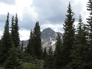
 This is the easiest and most expedient route to the top of Holy Cross. From Halfmoon trailhead you climb up and over Half Moon Pass (11,600') and down into East Cross Creek Basin. There is good camping near the creek at around 10,700'. Due to the extra elevation go up and over the pass on both the approach and return, many people choose to do this route in 2 days. Please observe all wilderness ethics and regulations. From the creek follow the well-defined trail up the north ridge, past tree line and to a semi-airy ridge with amazing views of the north face of Holy Cross. While you dont get to see the cross (which is on the east face), you do get to see Angelica and jagged ridges and cliffs of the north face proper. Holy Cross is certainly one of the most dramatic Sawatch mountains.
2. Halo Ridge
This breathtaking tour is longer, more exposed, and considerably more strenuous than the North Ridge. But the scenery is even more rewarding. You will climb three thirteeners in addition to Holy Cross, two of which are ranked and one which is #91 on Colorado's 100 Highest list. From the trailhead take the Fall Creek Trail for two and a half miles to the Notch Mountain Trail at 11,100'. Switchback for 3 miles up the Notch Mountain trail to the Notch Mountain shelter at 13,080'. You can stay at this shelter. Call the Forest Service Minturn office for info: 970-827-5715. From here you must traverse the Halo Ridge, a strenuous exposed traverse. It is 2.1 miles from here to the summit of Holy Cross. Traverse over ranked Point 13,248 (#441), unranked Point 13,373 and ranked Point 13,831, also known as Holy Cross Ridge, Colorado's 91st highest summit. Descend to the 13,500' saddle then climb the final half mile to Holy Cross's summit just barely over 14,000'. You can return over Halo Ridge or some people choose to return via the standard North Ridge. There are advantages to either option. If you return over Halo Ridge you will not have as much total vertical gain, even though you have to re-summit all three 13ers along the ridge. If you descend the North Ridge the journey is shorter and you are exposed above 13,000 feet for a shorter amount of time. It is NOT RECOMMENDED to attempt to bypass any summit along Halo Ridge in an effort to save elevation gain. Many of these summits are cliffed out and people have gotten into trouble trying to do this!
3. Angelica
This great snow climb is not nearly as famous as the Cross Couloir, but it is still good and often has snow later than the Cross Couloir providing a good alternative. It is not as long as the cross nor as complicated and technical but is similar in terms of steepness. Follow the standard North Ridge route over Half Moon Pass and down into the East Cross Creek basin. Cross the creek and leave the main trail at some campsites near the creek crossing. Pick your way through the forest, possibly doing some boulder hopping, and find a vague climber's trail. It becomes more distinct. Follow it as wind winds through some boulderfields on the west side of the creek for at least a mile until it flattens out at 11,500'. Hike across the bench west of Lake Patricia. Instead of following the draining basin towards the Bowl of Tears, head instead towards the obvious North Face. Climb steepening snow angling toward the west side of the face until you reach a prominent and obvious Y. Take the left branch and climb an excellent inset couloir to a notch at 13,700' where you rejoin the North Ridge route. From here it is a short class 2 jaunt to the summit.
 |
| Angelica is the couloir on the right side that has barely any snow left. |
4. Cross Couloir
This route is famous because it climbs Holy Cross's famous feature. For mountaineers it is a coveted snow climb and one of the most classic alpine routes in the Sawatch Range. It is also a coveted ski descent and many expert backcountry skiiers lust for this committing challenge. Start as for Angelica. Follow this route all the way to 11,500' at the bench with Lake Patricia. Instead of turning and taking on Holy Cross's North Face, follow the climber's trail into a boulderfield up the roughening basin until you reach the Bowl of Tears at 12,000'. The approach is over. Angle up the slopes starting left (south) of the couloir aiming right to bypass a cliff system at the bottom of the cross. You enter the couloir at 12,800'. Now for the business. First consider the avalanche potential, knowing that a gnarly cliff you wouldn't want to get swept over sits at the bottom of this committing couloir. Falling, for that matter, as either a skiier or a mountaineer is ill advised on this part of the route. Climb the couloir for over 1,000 feet. There is a possibility of resting on the cross ledge at 3/4 height depending on snow conditions. After a tough climb, the top will be a welcome treat. Either carefully ski down, or descend the North Ridge.
This route is famous because it climbs Holy Cross's famous feature. For mountaineers it is a coveted snow climb and one of the most classic alpine routes in the Sawatch Range. It is also a coveted ski descent and many expert backcountry skiiers lust for this committing challenge. Start as for Angelica. Follow this route all the way to 11,500' at the bench with Lake Patricia. Instead of turning and taking on Holy Cross's North Face, follow the climber's trail into a boulderfield up the roughening basin until you reach the Bowl of Tears at 12,000'. The approach is over. Angle up the slopes starting left (south) of the couloir aiming right to bypass a cliff system at the bottom of the cross. You enter the couloir at 12,800'. Now for the business. First consider the avalanche potential, knowing that a gnarly cliff you wouldn't want to get swept over sits at the bottom of this committing couloir. Falling, for that matter, as either a skiier or a mountaineer is ill advised on this part of the route. Climb the couloir for over 1,000 feet. There is a possibility of resting on the cross ledge at 3/4 height depending on snow conditions. After a tough climb, the top will be a welcome treat. Either carefully ski down, or descend the North Ridge.
SPECIAL CONSIDERATIONS
Mount of the Holy Cross is in the Holy Cross Wilderness area and special regulations apply. You must register at the trailhead and carry a permit with you that has a list of all the regulations. One of which is that fires are not allowed in the wilderness area. Please respect this rule and read and abide all of the other rules carefully. They are there for the greater good, so breaking these rules is not a strike against the government but a strike against all of us who want to enjoy this place for years to come.
 For some reason, Holy Cross has attracted inordinate numbers of accidents, tragedies and near misses over the years. As as result it has earned a reputation even among the non-climbing community. While many if not most 14ers have had tragic accidents involving mountaineers, for some reason people seem to remember the ones that occurred on Holy Cross more than any other. I have even heard the Holy Cross Wilderness dubbed the "Bermuda Triangle" of Colorado's backcountry. Much of this reputation, it seems to me, stems from one particularly disturbing accident that occurred a few years back when a woman separated from her climbing partner at around 13,800' on the Halo route with plans to quickly re-unite but, despite a lengthy search involving hundreds of people, was never seen again. There is no space here on this webpage to get into theories about what exactly happened in this particular instance, that discussion has occurred elsewhere and is not my goal now. It is, however, good to take this terrible tragedy--and others that have occurred on this mountain--and learn the lessons that they might teach. However, I have been back into the region a couple times now, and I have some ideas about why more people have trouble here than in other Colorado wilderness areas.
 For some reason, Holy Cross has attracted inordinate numbers of accidents, tragedies and near misses over the years. As as result it has earned a reputation even among the non-climbing community. While many if not most 14ers have had tragic accidents involving mountaineers, for some reason people seem to remember the ones that occurred on Holy Cross more than any other. I have even heard the Holy Cross Wilderness dubbed the "Bermuda Triangle" of Colorado's backcountry. Much of this reputation, it seems to me, stems from one particularly disturbing accident that occurred a few years back when a woman separated from her climbing partner at around 13,800' on the Halo route with plans to quickly re-unite but, despite a lengthy search involving hundreds of people, was never seen again. There is no space here on this webpage to get into theories about what exactly happened in this particular instance, that discussion has occurred elsewhere and is not my goal now. It is, however, good to take this terrible tragedy--and others that have occurred on this mountain--and learn the lessons that they might teach. However, I have been back into the region a couple times now, and I have some ideas about why more people have trouble here than in other Colorado wilderness areas.
The first problem is one of numbers. The fame of Holy Cross draws a fair number of annual visitors, and although crowds have become the norm on almost all 14ers in Colorado, Holy Cross for whatever reason seems to attract an even less experienced and less prepared demographic. Throw these large numbers of ill-prepared mountaineers into an environment with some of the particular objective hazards that I discuss below and the result is what you see today with Holy Cross's reputation.
Another hazard is the treacherous, bouldery, and cliffed-out terrain. The Holy Cross Wilderness, particularly the area immediately surrounding the mountain proper, is rough and uneven. It is filled with large glaciated boulders and cliffs of all sizes. This is a very rugged place. While some of the big cliffs are obvious, there are numerous small cliffs many of which are hidden among thick trees and brush. It would be easy to slip scrambling here and become injured. I could also see how it might be very difficult to find someone who had fallen into a crevice or something like that in between boulders.

The Holy Cross Wilderness is an amazing place, and I don't think anybody should be deterred from venturing into it by grim warnings and dark stories. It is smart for everyone, however (and I would probably say this about any backcountry), to always remember the essentials: map, compass, proper clothing, extra food, rudimentary medical supplies, etc, and to use extra caution and common sense when venturing into a place with proven and serial objective hazards.
Gerry Roach, in his book Colorado Fourteeners 3rd Edition, examines the case of the vanished mountaineer as well as his theory about Holy Cross's unique dangers in depth. It is a useful and informative article for anyone venturing into the area. The book itself is the bible to Colorado's 14ers in my opinion and a great place to start for anyone who is just becoming curious about the great peaks of this state.
STANDARD ROUTE (NORTH RIDGE)
Length: 11 miles (roundtrip)
Total Elevation gain: 5,800'
trail access: Half Moon Trail
 The North Ridge of Holy Cross is one of Colorado's best class 2 adventures. It is an amazing and challenging climb that takes you to Colorado's hallowed places. The length and total elevation required for this climb necessitate a two-day outing for many people. This might be advised for anyone whose conditioning might not be up for a one-day approach. That trade off, however, is that you will have to lug a heavy backpack over Half Moon Pass twice. Is it easier? The more environmentally conscience choice is to minimize your impact by climbing Holy Cross in one day. However, this is a place that deserves a slow, contemplative pace. I recommend a backpack of at least two days. Three might be preferable. Take your time and enjoy this place. Please minimize your impact by adhering to No Trace Wilderness ethic.
From Half Moon Trailhead, follow Half Moon Trail for 2 miles to Half Moon Pass at 11,600'. On my last trip, I discovered crossing this pass can be exciting in an afternoon thunderstorm. After summitting Half Moon Pass, descend gradually at first towards East Cross Creek. You will soon get your first views of the North Face of Holy Cross, an impressive sight. Soon the trail starts to descend more steeply and you round a corner and get an amazing view of the mountain and the East Cross Creek Basin, complete with steep granite walls on the basin's north flank, the mountain to the south, and a tallish waterfall in the center. You know now if you didn't before that this is a special place. Descend another 900 feet into the creek basin where some very nice campsites exist near the creek. Stay in one of the numbered campsites to minimize impact. You can be ticketed by rangers for camping elsewhere. Not only is it a legal issue anyway, it is environmental, so please respect this.
Cross East Cross Creek at a makeshift rock bridge and follow the trail as it winds up the northern slopes into the high alpine zone. At around 11,500' you will cross treeline. A bit later you will get your first glimpse of the mountain, much closer and even more imposing now. Follow the trail as the ridge tightens to a prominent notch at 13,700'. you can peer down an inset couloir, which is impressive whether it has snow or not. This is the top of Angelica. From here the trail gets rougher. Pick your way through class 2 to 2+ terrain to an impressive summit.
Do not get lost on the descent! Remember the route. Going too far west or north can pull you into the Cross Creek drainage (not the East Cross Creek drainage where you want to be.) While there are trails there, they will take you very far away from your vehicle. Also don't forget you have to go up and over (1,000') Half Moon Pass on the way out. As aforementioned this can be exciting if the afternoon storms are rolling in and exhausting anytime after a long climb of Holy Cross.
Length: 11 miles (roundtrip)
Total Elevation gain: 5,800'
trail access: Half Moon Trail

From Half Moon Trailhead, follow Half Moon Trail for 2 miles to Half Moon Pass at 11,600'. On my last trip, I discovered crossing this pass can be exciting in an afternoon thunderstorm. After summitting Half Moon Pass, descend gradually at first towards East Cross Creek. You will soon get your first views of the North Face of Holy Cross, an impressive sight. Soon the trail starts to descend more steeply and you round a corner and get an amazing view of the mountain and the East Cross Creek Basin, complete with steep granite walls on the basin's north flank, the mountain to the south, and a tallish waterfall in the center. You know now if you didn't before that this is a special place. Descend another 900 feet into the creek basin where some very nice campsites exist near the creek. Stay in one of the numbered campsites to minimize impact. You can be ticketed by rangers for camping elsewhere. Not only is it a legal issue anyway, it is environmental, so please respect this.
 |
| The Gore Range in the distance from the North Ridge |
Do not get lost on the descent! Remember the route. Going too far west or north can pull you into the Cross Creek drainage (not the East Cross Creek drainage where you want to be.) While there are trails there, they will take you very far away from your vehicle. Also don't forget you have to go up and over (1,000') Half Moon Pass on the way out. As aforementioned this can be exciting if the afternoon storms are rolling in and exhausting anytime after a long climb of Holy Cross.
TRIP REPORTS
Angels and Demons- The Two Faces of Mount of the Holy Cross
An article examining the profound beauty of Holy Cross and its surrounding territory as well as the unique objective dangers it boasts. Also included: a brief look at the mysterious disappearance of Michelle Vanek in 2005 and other accidents related to this area.
Longs, Holy Cross & McGregor Mountain (July 2012)
A week in July and a successful climb of the Left Side of McGregor Peak, right variation (II 5.8 R), the North Face of Longs Peak (II 5.4), and a two backpack and ascent of the standard route of Holy Cross.
Frustration in Paradise (July 2010)
Just because you don't make the summit doesn't always mean you "failed". This is an account of a really amazing trip in which we, unfortunately, did not make the summit.
Copyright notice: This website and all its contents are the intellectual property of www.coloradomountaineering.com and its authors. None of the content can be used or reproduced without the approval of www.coloradomountaineering.com.
Climbing and mountaineering are dangerous!! Please see the DISCLAIMER page
For information about how to contact us, visit this link
Just because you don't make the summit doesn't always mean you "failed". This is an account of a really amazing trip in which we, unfortunately, did not make the summit.
For information about how to contact us, visit this link
Friday, December 21, 2012
AREA PROFILE: Glenwood Canyon
INTRODUCTION
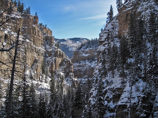 Glenwood Canyon is a major canyon along the Colorado River in the heart of the Rocky Mountains. It is a recreational hub for biking, hiking, riversports, spelunking and climbing as well as a major travel artery for Colorado and the west. The Cambrian and sedimentary rocks soar 2,000 feet above the river, providing dramatic scenery and unique geologic architecture. The canyon's limestone is home to many caves and other dramatic formations. Glenwood Canyon is an important travel corridor and during its history has been home to a railway, a bike path, a two-lane highway, and now a four-lane interstate which was completed in 1992. The Shoshone Dam and Powerplant, operated by Excel and located immediately downstream of the Hanging Lake recreation area, was completed in 1909 and utilizes hydroelectric energy to provide power to nearly 12,000 homes in the Glenwood Springs area.
From a climbing and hiking perspective, Glenwood Canyon is host to innumerable opportunities for recreation and exploration. Glenwood Canyon is in the White River National Forest and several of the trails can access, with a little proper preparation and know-how, the Flat Tops Wilderness Area. Several of the canyon's walls have been developed with both sport and trad routes, the most popular being No Name for traditional climbing and the Puoux for sport. Other types of climbing exist, however, including grade IV routes on the International Buttress in the heart of the canyon and Grizzly Creek Canyon's Mudwall as well as ice climbing in various locations. Glenwood Canyon is not only popular with hikers and climbers but with rafters, bikers, kayakers, inner-tubers, I-70 truckers, roller-skaters, sun bathers, and folk of all other sort. Most seem to coexist peacefully despite a premium on parking.
HISTORY
Glenwood Canyon has a unique and storied history. In the late 19th century the Denver and Rio Grande Western Railroad completed its tracks through the canyon, providing the first travel route through the canyon corridor. These tracks are owned and operated today by Union Pacific and are frequently used for coal transportation and by Amtrak. In 1906 the Taylor State Road was completed through the canyon. This highway was eventually paved. In 1992 the construction of I-70 was completed through the canyon. This section of I-70 was one of the last pieces of I-70 to be completed and, at the time, was the most expensive section of road in the interstate-highway system. Great care was taken during the construction of the I-70 project to preserve the canyon’s natural beauty and minimize the environmental impact. The project included 40 bridges and viaducts, miles of retaining walls, and three major tunnels. The entire system also includes considerable technology for monitoring and controlling traffic, accidents, and rockfall along this section of the interstate.
Glenwood Canyon also is home to the Shoshone Dam and Powerplant. When this project was completed in 1909 it made Glenwood Springs one of the first fully-powered cities in the United States.
Glenwood Canyon is also home to several major hot springs, many of which can be enjoyed for free at river level during low water. The Yampah spring is the largest and is the source for the ultra-popular Hot Springs Pool in Glenwood Springs. Old West gunslinger Doc Holliday died in Glenwood Springs where he came to find some relief for his tuberculosis in the Yampah spring.
Teddy Roosevelt frequented the Hotel Colorado at the mouth of the canyon many times during his life. Supposedly, one day after a failed bear hunt Hotel Colorado maids presented him with a stuffed bear made of scrap material as a consolation for failing to bag the real thing. As legend would have it, Teddy Roosevelt presented the bear to his daughter, the idea caught on, and the toy now known as the teddy bear was born. Teddy Roosevelt, interestingly, wasn't the only celebrity who frequented the Hotel Colorado. It was a mountain retreat for many of America's elite of the time. President William Howard Taft, The "Unsinkable" Molly Brown, "Diamond" Jack Alterie, and even Al Capone made frequent trips to the hotel. The building has such a storied (and even violent) history that it is rumored to be haunted. Almost every Glenwood Springs local either has or knows someone who has a Hotel Colorado ghost story.
HIKING
There are numerous quality hikes in Glenwood Canyon, many of which offer exciting potential for more in-depth exploration. The Glenwood Canyon Bike Path is a concrete trail that follows the river for the entire length of the canyon from near Dotsero to Glenwood Springs. This 18-mile trail is popular for joggers, bikers, and casual hikers.
The Grizzly Creek trail is an 8-mile trek (roundtrip) up a wide and rugged canyon along a perennial creek that provides the water supply for the City of Glenwood Springs. This popular trail is used by hikers of all abilities, from restless I-70 drivers shaking their legs after a long driving shift to casual hikers who rarely go past the first mile to full-on adventurers who continue well-past the seeming "end" of the trail, perhaps all the way into the Flat Tops Wilderness Area.
The Jess Weaver trail follows No Name Canyon, the next drainage west of Grizzly Creek. No Name also offers miles of hiking in a beautiful canyon setting.
The most popular trail, however, is the Hanging Lake trail which climbs 1,200 strenuous feet to a verdant oasis of waterfalls and lakes. Surely this is one of the most popular hiking trails in this part of the state and for good reason. While Hanging Lake can be very busy during the summer, especially on weekends, solitude can still be found in the off-season. Fall is one of the best times to visit the canyon. The combination of colors in the beautiful lake setting is breathtaking. Wintertime can be treacherous, as dangerous ice can form in the canyon. For those with knowledge of ice travel and ice climbing the trip can be very rewarding.
ROCK CLIMBING
Glenwood Canyon has several quality climbing areas that offer a variety of climbing adventures. The rock in Glenwood Canyon is a mixture of limestone, quartzite, and granite of mixed quality. In the 1960's and 70's, legendary Colorado climber and occasional Glenwood local Layton Kor spent much time training on the rock in Glenwood Canyon for more heralded first ascents across the Southwest, such as mega-classics the Naked Edge (III 5.9 A3) in Eldorado Canyon, The Yellow Wall (V 5.8 A4) on the Diamond on Longs Peak, the West Buttress (VI 5.10 A3) on El Cap, and the Kor-Ingalls (III 5.9+) route on Castleton Tower just to name a few. Relics of Kor's extensive exploration of the walls of Glenwood Canyon can be found in surprising places, from random pitons on the Puoux to established routes on the Mudwall to unknown random gear on many of the canyon's most obscure walls. It has been a common experience of modern Glenwood Canyon climbing pioneers to be climbing up dirty towers and faces, thinking they were establishing a brand new route only to find pitons and anchors likely placed there by Kor.
Despite this history and the immense wealth of large walls in the Canyon, it is a relatively untapped and under-appreciated climbing destination. There are several contributing factors to the obscurity of Glenwood Canyon's climbing. One is the presence of I-70. At crags like the Airy Block and the Puoux, the noise of numerous semis, cars, and SUVs is certainly enough to damper your experience. I-70 also takes up alot of space and limits the portals of access, making the approach to many walls quite a task, particularly those that are located on the opposite side of the river. The other deterring factor is the large band of loose, blocky quartzite that dominates much of the canyon terrain. While this large layer has yielded some interesting climbs and crags such as the Mudwall and the Deadhorse wall, its gnarly character eliminate all but hardened adventure climbers. Still, there are at least half a dozen established crags of both traditional and sport climbing, and there is amazing potential for expansion if you are willing to put in a little work. Here is a list of the most-popular Glenwood Canyon climbing destinations:
The Puoux- a limestone sport crag near the No Name exit. The Puoux (pronounced “Pukes”) offers easily accessible sport climbing immediately off of I-70 with difficulty ranging from 5.7 to 5.14. This fairly popular spot keeps the locals in shape. Some of the established sport lines include:


No Name Canyon- located just off the Jess Weaver trail, this area has several single-pitch trad climbing routes from 5.4 to 5.12. Here are some of the No Name favorites:


The Neighborhood- a sport crag near the canyon mouth just east of Glenwood Springs on the south side of the river. This little spot is easily accessible for Glenwood locals as an afterwork/school climb. The lines rate from 5.9 to 5.12b
Big (or almost big) Wall:


A non-exhaustive list of some of the other, less-traveled climbing crags in Glenwood Canyon:
The Airy Block- an interesting fin of granite with several good moderate trad climbs. The only catch is it's right next to the freeway...
Dead Horse Crag- this quartzite crag is accessed off the trail to Hanging Lake. There are several climbs of surprising quality from 5.9 to hard 5.11. Most require some gear to supplement bolts.
Fountain Buttress- Some of the best rock in the canyon, but difficult to access due to a river crossing. A tyrolean is sometimes set-up here, otherwise you will have to use a boat, swim or wait until very low water and walk across. Despite the excellent rock, classic routes, and massive potential, this rock sees surprisingly little use.
The Grey Slabs- Slabby, limestone climbing on the canyon's western end. Access by parking near the Hot Springs or Vapor Caves and hiking upstream along the bike path. Good moderate sport routes.
The Surgery Buttress- This limestone crag on the canyon's eastern end is also under-appreciated. There are about 15 climbs here from 5.9 to 5.12a.
OTHER RECREATIONAL ACTIVITIES
Biking- The Glenwood Canyon Bike Path offers 18 miles of uninterrupted concrete pathway through a beautiful canyon setting. This trail is mellow and popular and provides a nice opportunity for a good workout/escape.
Spelunking-The limestone of Glenwood Canyon has formed many caves, some of which have been explored and some of which have not. The Glenwood Caverns, high on the northern side of the canyon near Glenwood, offers established cave tours in a family-oriented amusement park setting. Undeveloped caves such as Cave of the Clouds offer something for those with a sense of adventure looking for something off-the-beaten-path.
River Sports- River sports are one of the most popular recreational activities in Glenwood Canyon. There are many options for kayaking and rafting within the canyon ranging from beginner to expert only. Local commercial outfitters run half & full day raft trips down the Colorado River through Glenwood Canyon. This is also an excellent place to learn and hone your kayaking skills. The runs include (from top to bottom):
SEASON
Recreation is available in Glenwood Canyon year round. In the summer the canyon is busy with people pursuing adventures of all sorts. In the winter, however, the narrow canyon is mostly shaded and cold but you can still hike and climb. There is, in fact, a long-running tradition amongst kayakers to float the Shoshone section of the Colorado River on New Year’s Day.


GETTING THERE
Glenwood Canyon is accessible from I-70 just east of Glenwood Springs. There are several exits from the freeway from which to launch your adventure, the most popular are No Name (exit 119), Grizzly Creek (exit 121), and Hanging Lake (exit 125).
CAMPING
The only legal place to camp inside Glenwood Canyon is at the developed Glenwood Canyon Resort at the No Name exit. The resort offers cabins, showers, rec rooms, and tent sites.
EXTERNAL LINKS
Mountain Project climbing pages:
Puoux
No Name Canyon
The Neighborhood
Glenwood Hot Springs- The World's Largest Hot Springs Pool.
Copyright notice: This website and all its contents are the intellectual property of www.coloradomountaineering.com and its authors. None of the content can be used or reproduced without the approval of www.coloradomountaineering.com.
Climbing and mountaineering are dangerous!! Please see the DISCLAIMER page
For information about how to contact us, visit this link

From a climbing and hiking perspective, Glenwood Canyon is host to innumerable opportunities for recreation and exploration. Glenwood Canyon is in the White River National Forest and several of the trails can access, with a little proper preparation and know-how, the Flat Tops Wilderness Area. Several of the canyon's walls have been developed with both sport and trad routes, the most popular being No Name for traditional climbing and the Puoux for sport. Other types of climbing exist, however, including grade IV routes on the International Buttress in the heart of the canyon and Grizzly Creek Canyon's Mudwall as well as ice climbing in various locations. Glenwood Canyon is not only popular with hikers and climbers but with rafters, bikers, kayakers, inner-tubers, I-70 truckers, roller-skaters, sun bathers, and folk of all other sort. Most seem to coexist peacefully despite a premium on parking.
HISTORY
 |
| Record high water in Glenwood Canyon- June 2011 |
Glenwood Canyon also is home to the Shoshone Dam and Powerplant. When this project was completed in 1909 it made Glenwood Springs one of the first fully-powered cities in the United States.
Glenwood Canyon is also home to several major hot springs, many of which can be enjoyed for free at river level during low water. The Yampah spring is the largest and is the source for the ultra-popular Hot Springs Pool in Glenwood Springs. Old West gunslinger Doc Holliday died in Glenwood Springs where he came to find some relief for his tuberculosis in the Yampah spring.
Teddy Roosevelt frequented the Hotel Colorado at the mouth of the canyon many times during his life. Supposedly, one day after a failed bear hunt Hotel Colorado maids presented him with a stuffed bear made of scrap material as a consolation for failing to bag the real thing. As legend would have it, Teddy Roosevelt presented the bear to his daughter, the idea caught on, and the toy now known as the teddy bear was born. Teddy Roosevelt, interestingly, wasn't the only celebrity who frequented the Hotel Colorado. It was a mountain retreat for many of America's elite of the time. President William Howard Taft, The "Unsinkable" Molly Brown, "Diamond" Jack Alterie, and even Al Capone made frequent trips to the hotel. The building has such a storied (and even violent) history that it is rumored to be haunted. Almost every Glenwood Springs local either has or knows someone who has a Hotel Colorado ghost story.
HIKING
There are numerous quality hikes in Glenwood Canyon, many of which offer exciting potential for more in-depth exploration. The Glenwood Canyon Bike Path is a concrete trail that follows the river for the entire length of the canyon from near Dotsero to Glenwood Springs. This 18-mile trail is popular for joggers, bikers, and casual hikers.
 |
| Scenery along the Grizzly Creek Trail |
The Jess Weaver trail follows No Name Canyon, the next drainage west of Grizzly Creek. No Name also offers miles of hiking in a beautiful canyon setting.
The most popular trail, however, is the Hanging Lake trail which climbs 1,200 strenuous feet to a verdant oasis of waterfalls and lakes. Surely this is one of the most popular hiking trails in this part of the state and for good reason. While Hanging Lake can be very busy during the summer, especially on weekends, solitude can still be found in the off-season. Fall is one of the best times to visit the canyon. The combination of colors in the beautiful lake setting is breathtaking. Wintertime can be treacherous, as dangerous ice can form in the canyon. For those with knowledge of ice travel and ice climbing the trip can be very rewarding.
ROCK CLIMBING
Glenwood Canyon has several quality climbing areas that offer a variety of climbing adventures. The rock in Glenwood Canyon is a mixture of limestone, quartzite, and granite of mixed quality. In the 1960's and 70's, legendary Colorado climber and occasional Glenwood local Layton Kor spent much time training on the rock in Glenwood Canyon for more heralded first ascents across the Southwest, such as mega-classics the Naked Edge (III 5.9 A3) in Eldorado Canyon, The Yellow Wall (V 5.8 A4) on the Diamond on Longs Peak, the West Buttress (VI 5.10 A3) on El Cap, and the Kor-Ingalls (III 5.9+) route on Castleton Tower just to name a few. Relics of Kor's extensive exploration of the walls of Glenwood Canyon can be found in surprising places, from random pitons on the Puoux to established routes on the Mudwall to unknown random gear on many of the canyon's most obscure walls. It has been a common experience of modern Glenwood Canyon climbing pioneers to be climbing up dirty towers and faces, thinking they were establishing a brand new route only to find pitons and anchors likely placed there by Kor.
 |
| Ironing Board Direct (5.10b) in No Name Canyon |
Despite this history and the immense wealth of large walls in the Canyon, it is a relatively untapped and under-appreciated climbing destination. There are several contributing factors to the obscurity of Glenwood Canyon's climbing. One is the presence of I-70. At crags like the Airy Block and the Puoux, the noise of numerous semis, cars, and SUVs is certainly enough to damper your experience. I-70 also takes up alot of space and limits the portals of access, making the approach to many walls quite a task, particularly those that are located on the opposite side of the river. The other deterring factor is the large band of loose, blocky quartzite that dominates much of the canyon terrain. While this large layer has yielded some interesting climbs and crags such as the Mudwall and the Deadhorse wall, its gnarly character eliminate all but hardened adventure climbers. Still, there are at least half a dozen established crags of both traditional and sport climbing, and there is amazing potential for expansion if you are willing to put in a little work. Here is a list of the most-popular Glenwood Canyon climbing destinations:
The Puoux- a limestone sport crag near the No Name exit. The Puoux (pronounced “Pukes”) offers easily accessible sport climbing immediately off of I-70 with difficulty ranging from 5.7 to 5.14. This fairly popular spot keeps the locals in shape. Some of the established sport lines include:
| Route | Type | Pitches | Difficulty | Location/Description |
|---|---|---|---|---|
| No Name 1 (aka Graybeard) | Sport | 1 | 5.8 | This excellent pitch is one of the better moderate routes at the wall |
| Pass the Ditchie | Sport | 1 | 5.9 | Scramble up to a ledge and climb an arcing dihedral past a piton to the anchors. Fun! |
| No Name 5 (Roadside Attraction) | Sport | 1 | 5.10a | Polished and popular. This is probably the most frequently climbed pitch in the canyon |
| No Name 4 (aka Moral Decay) | Sport | 1 | 5.10a | Another good moderate route on solid rock. 60 ft up a slab then onto a flake |
| Youth Warm Up | Sport | 1 | 5.11c | On the left side of the Main Wall at the Puoux. Challenging and popular route. |
| No Name 18 (aka Kors Korner) | Sport | 1 | 5.11d | A challenging route in the middle of the main wall. |
| Urban Cowboy | Sport | 1 | 5.12a | One of the best 5.12s around. Steep, perfectly bolted. Does have some manufactured holds. |
| The Birdman | Sport | 1 | 5.13a | A 55 ft route on the left side of the main wall. Part of recent development at the upper grades |
| Fault Line | Sport | 1 | 5.13d | A local test piece! A photo of Joe Kinder on this difficult route accelerated the popularity of the Puoux |


No Name Canyon- located just off the Jess Weaver trail, this area has several single-pitch trad climbing routes from 5.4 to 5.12. Here are some of the No Name favorites:
| Route | Type | Pitches | Difficulty | Location/Description |
|---|---|---|---|---|
| Second Dihedral | trad | 1 | 5.6 | A high-quality corner, just to the right of the Pink Face. Perfect first lead. |
| Jungle Book | trad | 1 | 5.7 | An open corner just to the right of Unnamed aka "The Ironing Board" (5.9) |
| Electric Butterfly | trad | 1 | 5.8 | A fun, moderate climb next to the power shack just before the footbridge over No Name Creek. Can be done as TR |
| The Ironing Board | trad | 1 | 5.9 | A right-trending splitter with challenging gear placements and a 5.10b direct variation |
| The Pink Face | trad | 1 | 5.10+ | A long (110') splitter just left of Second Dihedral. |
| Lone Pine Direct | trad | 1 | 5.10 | Down and left from the Pink Face heading towards a pine tree. Thin splitter with finger to hand sized moves |
| Lightning Bolt Crack | trad | 1 | 5.10 | West side of creek on the Poison Ivy Wall. |
| Lost Dog | trad | 1 | 5.12- | A recently posted route that comes right out of the creek. Three bolts in addition to finger sized gear. Possible #3 Camalot sized piece |


The Neighborhood- a sport crag near the canyon mouth just east of Glenwood Springs on the south side of the river. This little spot is easily accessible for Glenwood locals as an afterwork/school climb. The lines rate from 5.9 to 5.12b
| Route | Type | Pitches | Difficulty | Location/Description |
|---|---|---|---|---|
| Planet Janet | sport | 1 | 5.9+ | On the far right side of the Zipper Buttress. Short climb that follows a unique "groove". |
| California Dreaming | sport | 1 | 5.9+ | Right-facing dihedral 20 feet left of where trail meets crag. |
| Git 'Er Done | sport | 1 | 5.10c | Right side of Zipper Buttress starting in a chimney. |
| Zipper | sport | 1 | 5.11c | A 7-bolt climb sometimes called the best 5.11 in Glenwood Canyon |
| Enter the Dragon | sport | 1 | 5.12a | The feature route on the Dragon Cave wall and one of the best 5.12's in the canyon. |
| Bitch Slap | sport | 1 | 5.12b | Shares first bolts with The Tube but veers left. |
Big (or almost big) Wall:
| Route | Type | Pitches | Difficulty | Location/Description |
|---|---|---|---|---|
| The International | trad | 18 | 5.10+, Grade IV | A massive Grad IV climb in-between the Shoshone and Hanging Lake exits on south bank of river |
| Mudflap Girl | trad | 10 | 5.10, Grade IV | A monster, chossy wall about a mile up Grizzly creek on the west side of canyon. Can be seen from I-70 |


A non-exhaustive list of some of the other, less-traveled climbing crags in Glenwood Canyon:
The Airy Block- an interesting fin of granite with several good moderate trad climbs. The only catch is it's right next to the freeway...
Dead Horse Crag- this quartzite crag is accessed off the trail to Hanging Lake. There are several climbs of surprising quality from 5.9 to hard 5.11. Most require some gear to supplement bolts.
Fountain Buttress- Some of the best rock in the canyon, but difficult to access due to a river crossing. A tyrolean is sometimes set-up here, otherwise you will have to use a boat, swim or wait until very low water and walk across. Despite the excellent rock, classic routes, and massive potential, this rock sees surprisingly little use.
The Grey Slabs- Slabby, limestone climbing on the canyon's western end. Access by parking near the Hot Springs or Vapor Caves and hiking upstream along the bike path. Good moderate sport routes.
The Surgery Buttress- This limestone crag on the canyon's eastern end is also under-appreciated. There are about 15 climbs here from 5.9 to 5.12a.
OTHER RECREATIONAL ACTIVITIES
Biking- The Glenwood Canyon Bike Path offers 18 miles of uninterrupted concrete pathway through a beautiful canyon setting. This trail is mellow and popular and provides a nice opportunity for a good workout/escape.
 |
| Rafters in Glenwood Canyon |
River Sports- River sports are one of the most popular recreational activities in Glenwood Canyon. There are many options for kayaking and rafting within the canyon ranging from beginner to expert only. Local commercial outfitters run half & full day raft trips down the Colorado River through Glenwood Canyon. This is also an excellent place to learn and hone your kayaking skills. The runs include (from top to bottom):
| Section | Put-in | Take-out | Length | <2,000cfs (low) | 2,000-5,000 cfs (medium) | 5,000-10,000 cfs (high) | >10,000 cfs (cranking) |
|---|---|---|---|---|---|---|---|
| Dotsero-Bair Ranch | Bike Path east trailhead | Bair Ranch | 3 miles | class I+ | class I+ | class I + | class II |
| Barrel Springs | Hanging Lake | Shoshone Power Plant | 2 miles | class IV+ (P) | class V (P) | class V (P) | class V+ (P) |
| Shoshone | Shoshone Power Plant | Grizzly Creek | 2 miles | class III | class III | class IV | class IV+ |
| Grizzly | Grizzly Creek | Two Rivers Park | 6 miles | class II | class II+ | class III | class III |
SEASON
Recreation is available in Glenwood Canyon year round. In the summer the canyon is busy with people pursuing adventures of all sorts. In the winter, however, the narrow canyon is mostly shaded and cold but you can still hike and climb. There is, in fact, a long-running tradition amongst kayakers to float the Shoshone section of the Colorado River on New Year’s Day.


Glenwood Canyon is accessible from I-70 just east of Glenwood Springs. There are several exits from the freeway from which to launch your adventure, the most popular are No Name (exit 119), Grizzly Creek (exit 121), and Hanging Lake (exit 125).
CAMPING
The only legal place to camp inside Glenwood Canyon is at the developed Glenwood Canyon Resort at the No Name exit. The resort offers cabins, showers, rec rooms, and tent sites.
EXTERNAL LINKS
Mountain Project climbing pages:
Puoux
No Name Canyon
The Neighborhood
Glenwood Hot Springs- The World's Largest Hot Springs Pool.
Monday, December 17, 2012
AREA PROFILE: Unaweep Canyon
INTRODUCTION

HISTORY
The vast granite walls of Unaweep saw very little attention in terms of rock climbing until the 1980's and 1990's when climber K.C. Baum and his friends spent a lot of time in the canyon developing the main routes in the canyon, many of which are Unaweep classics still today. In the subsequent decades, development in Unaweep has been slow. In recent years a more exploratory group of young climbers, especially Rob Pizem and others, have developed new routes in the canyon. Many of these new routes are very difficult.
 BOULDERING
In today's climbing landscape the vast boulderfields of Nine Mile Hill, a long sloping hill that precedes the main granite as you approach from the town of Whitewater, have grown more popular than the granite itself. These boulders consist of Dakota and Burro Canyon sandstone and are sometimes flaky and fragile. However, there are many classic areas, some of which were first climbed two decades ago or more. Some of the classic areas include the Fossil Boulder and the Plethora Boulders, Chinese Algebra, the Ice Cubes, just to name a few.
GETTING THERE
From Grand Junction take Highway 50 south towards Montrose and Delta. After 9 miles you will come to a small town called Whitewater. Exit Highway 50 to the west onto Highway 141 toward Naturita, CO. For the first 14 miles you will climb slowly up the slightly mis-named "Nine Mile Hill". The vast amount of the bouldering as well as several crags (such as the Grit Wall and the Peter Wall) are located along this section. The rock is almost entirely Dakota and Burro Canyon Sandstone. After about ten miles you will start to enter the granite inner canyon. You reach the turnoff for Divide Road at mile 14.5.
THE CANYON
Access Fund TH
 The Access Fund trailhead is found 2.1 miles past the turn off to Divide Road. It provides access to some of the most popular cliffs in the canyon and for good reason. The Access Fund trail allows you to legally reach the base of the Sunday Wall, the Hidden Valley Wall, and the Fortress Wall: enough vertical terrain to provide many hours of entertainment.
Some of the most popular routes (left to right):
Mother's Buttress
 The Mother's Buttress area is probably the second most busy climbing area of the canyon. It is located 3.1 miles past the turn off to Divide Road, about a mile past the Access Fund trail. There are a variety of routes from some of the most user-friendly single pitch trad routes to some truly challenging and committing grade III multi-pitch adventures. The Upper and Middle Mother's Buttress are better known for long, challenging multi-pitch routes where the Lower Mother's Buttress is popular for its concentration of easy and moderate trad routes, some of which can be top-roped by scrambling up from the formation's east side.
Some of the more popular routes at the Mother's Buttress area:
Sun Tower
The Sun Tower area is a collection of fun spires and cliffs that make for a good smattering of traditional and sport climbs. This area is not as busy as the Access Fund or Lower Mother's, so it is unlikely you will encounter a crowd of climbers here. The Sun Tower is located just east of mm 135 in the main canyon. The access is on private property but is allowed via a well-marked and developed trail.
Other areas
This is only an introduction to the climbing available in Unaweep Canyon. Some of the other popular destinations include: The Mighty Mouse Wall, the Divide Wall, the Rainbow Buttress, the Grit Wall, the Unaweep Wall, Castle Rock, the Thimble, and others.
External Links
Unaweep Canyon on Mountainproject.com
Unaweep Canyon on Summitpost.org
The Sunday Wall on Summitpost.org
Visit THE ARCHIVE: A list of most of our articles sorted by department
Copyright notice: This website and all its contents are the intellectual property of www.coloradomountaineering.com and its authors. None of the content can be used or reproduced without the approval of www.coloradomountaineering.com.
Climbing and mountaineering are dangerous!! Please see the DISCLAIMER page
For information about how to contact us, visit this link

Unaweep Canyon is a vast and amazing venue for traditional and alpine style climbing. It's vast granite walls are filled with a lifetime of established routes as well as many many possibilities for future development. The boulder fields of Dakota and Burro Canyon Sandstone that you pass through en route to the granite offer an almost endless supply of boulders, many of which have been developed but many of which are yet to be explored.
HISTORY
The vast granite walls of Unaweep saw very little attention in terms of rock climbing until the 1980's and 1990's when climber K.C. Baum and his friends spent a lot of time in the canyon developing the main routes in the canyon, many of which are Unaweep classics still today. In the subsequent decades, development in Unaweep has been slow. In recent years a more exploratory group of young climbers, especially Rob Pizem and others, have developed new routes in the canyon. Many of these new routes are very difficult.

In today's climbing landscape the vast boulderfields of Nine Mile Hill, a long sloping hill that precedes the main granite as you approach from the town of Whitewater, have grown more popular than the granite itself. These boulders consist of Dakota and Burro Canyon sandstone and are sometimes flaky and fragile. However, there are many classic areas, some of which were first climbed two decades ago or more. Some of the classic areas include the Fossil Boulder and the Plethora Boulders, Chinese Algebra, the Ice Cubes, just to name a few.
GETTING THERE
From Grand Junction take Highway 50 south towards Montrose and Delta. After 9 miles you will come to a small town called Whitewater. Exit Highway 50 to the west onto Highway 141 toward Naturita, CO. For the first 14 miles you will climb slowly up the slightly mis-named "Nine Mile Hill". The vast amount of the bouldering as well as several crags (such as the Grit Wall and the Peter Wall) are located along this section. The rock is almost entirely Dakota and Burro Canyon Sandstone. After about ten miles you will start to enter the granite inner canyon. You reach the turnoff for Divide Road at mile 14.5.
THE CANYON
Access Fund TH

Some of the most popular routes (left to right):
| Name | Type | Pitches | Difficulty |
|---|---|---|---|
| Beginner's Luck | trad | 1 | 5.7+ |
| Napa Valley | trad | 5 | 5.11- |
| Don Juan | trad | 1 | 5.6 |
| Bandito | trad | 1 | 5.9 |
| Three's Company | trad | 1 | 5.8+ |
| Echoes | trad | 6 | 5.12d |
| Bridge of Air | sport | 1 | 5.12a |
| Optical Illusions | sport | 1 | 5.11c |
| Standard Route | trad | 1 | 5.7 |
| Sweet Sunday Serenade | trad | 3 | 5.9 |
| Sun Dancer | trad | 2 | 5.8 |
Mother's Buttress

Some of the more popular routes at the Mother's Buttress area:
| Name | Type | Pitches | Difficulty |
|---|---|---|---|
| Doppelganger | trad | 3 | 5.11 |
| Questions and Answers | trad | 3 | 5.10+ |
| Centurion | trad | 3 | 5.11b |
| Flora Dora | trad | 3 | 5.11 |
| Rise of the Phoenix | trad | 1 | 5.10a |
| Alex's Tower | trad | 1 | 5.8 |
| Mint Jam | trad | 1 | 5.8+ |
| No Name Route | trad | 1 | 5.9+ |
| Welcoming Party | trad | 1 | 5.7+ |
| Guide's Route | trad | 6 | 5.9 |
Sun Tower
 |
| Dovercourt (5.7) Lower Sun Tower |
| Name | Type | Pitches | Difficulty |
|---|---|---|---|
| Sunup | sport | 1 | 5.8+ |
| Crack of Don | trad | 1 | 5.6 |
| Dovercourt | trad | 1 | 5.7 |
| Betty and Ray's Adventure | trad | 3 | 5.6 |
| Twin Owls | trad | 2 | 5.9 |
| Daffy Duck Pinnacle | trad | 2 | 5.10- |
Other areas
This is only an introduction to the climbing available in Unaweep Canyon. Some of the other popular destinations include: The Mighty Mouse Wall, the Divide Wall, the Rainbow Buttress, the Grit Wall, the Unaweep Wall, Castle Rock, the Thimble, and others.
External Links
Unaweep Canyon on Mountainproject.com
Unaweep Canyon on Summitpost.org
The Sunday Wall on Summitpost.org
Visit THE ARCHIVE: A list of most of our articles sorted by department
Sunday, December 16, 2012
NEWS: 11-Year-Olds Making Climbing Headlines
Although it does not directly pertain to Colorado, this astounding news is relevant to all in the climbing community and thus worth reporting here. 11-year-old Mirko Caballero sent classic 5.14a Ubermensch in California just a few days ago, according to Rock and Ice Magazine and Caballero's 8a.nu scorecard. This classic route was originally put up by Chris Sharma.
Caballero isn't the only 11 year old making headlines. Climbing phenom Ashima Shiraishi from New York redpointed Lucifer and Southern Smoke, both rated 5.14c, at Red River Gorge and flashed Omaha Beach (5.14a). She was the youngest person, male or female, to both flash a 5.14a and redpoint a 5.14c.
Below is a video of Ashima climbing, including her ascent of V13 Crown of Aragorn in Hueco Tanks, TX:
Visit THE ARCHIVE: A list of most of our articles sorted by department
Copyright notice: This website and all its contents are the intellectual property of www.coloradomountaineering.com and its authors. None of the content can be used or reproduced without the approval of www.coloradomountaineering.com.
Climbing and mountaineering are dangerous!! Please see the DISCLAIMER page
For information about how to contact us, visit this link
Caballero isn't the only 11 year old making headlines. Climbing phenom Ashima Shiraishi from New York redpointed Lucifer and Southern Smoke, both rated 5.14c, at Red River Gorge and flashed Omaha Beach (5.14a). She was the youngest person, male or female, to both flash a 5.14a and redpoint a 5.14c.
Below is a video of Ashima climbing, including her ascent of V13 Crown of Aragorn in Hueco Tanks, TX:
Subscribe to:
Posts (Atom)