Showing posts with label Colorado 13ers. Show all posts

Sunday, December 4, 2016

2017 Colorado Mountaineering Calendar Now Available!

The 2017 Colorado Mountaineering calendar is now available from the Lulu bookstore. Makes a great gift or stocking stuffer for your mountaineering, climbing or scenery-gazing loved one. Includes images of Longs Peak, Mount of the Holy Cross, Conundrum Peak, the Grenadier Range, the Gore Range, the Flat Tops and more. Retailed at the reasonable rate of $14.99. Order now and receive it before Christmas! You can preview or purchase this item here at the Lulu.com book store or click on the following icon:

Support independent publishing: Buy this calendar on Lulu.

**UPDATE** As the new year rapidly approaches, the 2017 Colorado Mountaineering calendar has now been marked down 20%!! Act now to still receive yours before 2017 begins!**

Visit THE ARCHIVE: A list of most of our articles sorted by department

find us on facebook

Copyright notice: This website and all its contents are the intellectual property of www.coloradomountaineering.com and its authors. None of the content can be used or reproduced without the approval of www.coloradomountaineering.com.

Climbing and mountaineering are dangerous!! Please see the DISCLAIMER page
For information about how to contact us, visit this link


Wednesday, July 1, 2015

VIDEO: Skiing the 13ers with Chris Davenport

Check out this video of Chris Davenport's push to ski all of the Centennial 13,000 foot peaks in Colorado.


Visit THE ARCHIVE: A list of most of our articles sorted by department

find us on facebook


Copyright notice: This website and all its contents are the intellectual property of www.coloradomountaineering.com and its authors. None of the content can be used or reproduced without the approval of www.coloradomountaineering.com.

Climbing and mountaineering are dangerous!! Please see the DISCLAIMER page
For information about how to contact us, visit this link


Thursday, October 3, 2013

Feature: Lost in the San Juans

The Grenadiers:
A Week of Rain, Lightning and Getting Lost in Colorado’s Largest Wilderness
by Brian Wright

Arrow and Vestal Peak
Arrow and Vestal Peak coming out of the fog
I’d lost my fiancĂ©e. Sometime between when she yelled ahead to tell me she wanted to stop and take photos of some flowers and when I’d sat three minutes later on a log to wait for her to catch up, we’d gotten separated. “Ella!” I screamed at the top of my lungs, running in my heavy hiking boots back up the steep trail towards Vestal Basin. My legs were tired, my ankle injured. We had just spent the previous day battling up the 1,500-foot trail from Elk Creek to the base of Vestal Peak in Colorado’s Weminuche Wilderness on a trail that had proven not to be a trail at all. What we had hoped would be a short, albeit steep, hike had turned into a multi-hour obstacle course of downed lumber and loose rock.

An hour had gone by since we’d last seen each other. The worst of all possibilities were surfacing in my mind. Maybe she’d fallen on the uneven “trail”. Maybe she’d had to go back to camp for a forgotten item. The horrifying thought even occurred to me, since she’d seemingly disappeared without a trace, that a mountain lion had dragged her off the trail. At that point, anything seemed possible.

The clouds were building, again. Although we had had a morning of beautiful blue skies, already the storms that had dominated every afternoon of our week-long backpack trip were returning. I ran farther up the trail, almost all the way back to our camp from the previous evening. There was no sign of her. “Where did you go?” I yelled fruitlessly. I’d read about people in situations like this, but I’d never been in one myself. I needed to find someone to help. I needed to find her. As the storms built and my desperation deepened, I knew there was no way I could leave Vestal Basin until I found her.
*                              *                             *

The Weminuche Wilderness Area is the largest wilderness in Colorado. At nearly half a million acres, it encompasses a huge swath of the San Juan Mountains in-between the towns of Durango and Silverton. There are over 500 miles of trails through the Weminuche, including a portion of the popular Colorado Trail, and countless other rugged passes and unmaintained routes.

Wham Ridge and Vestal Peak
Wham Ridge of Vestal Peak in the Grenadier
Range of the San Juan Montains
But it wasn’t the trails that we had come for, but the mountains, and no other place in the state boasts so rugged and dramatic a collection of high peaks. In ten square miles at the heart of the Weminuche, there are 10 of Colorado’s 104 highest peaks, including four fourteeners (Sunlight, Eolus, North Eolus, and Windom) and many of Colorado’s most classic thirteeners. Our sights had been set on the Grenadier Range, a sub-range of the San Juan Mountains that runs east to west a few miles south of Silverton. The Grenadiers are a chain of dramatic quartzite peaks that form one of Colorado’s most unique and dramatic mountain skylines. Great ramps of solid, dark rock angle into the sky. In his book Colorado’s Thirteeners: 13,800 to 13,999 Feet, Gerry Roach says that the mountains of the Grenadier Range “take on a new dimension as peaks leap from a mold that could belong to another planet.” It was this unique architecture that drew us to these mountains, for some of the best and most popular technical alpine climbs in the state reside here.

Our plan had been to start at the Molas Trailhead (thereby foregoing the $85 train ride from Durango into the Animas River Canyon, which would have saved us over six miles and 1,800 feet of both elevation gain and loss) and hike down along a portion of the Colorado Trail until we could turn south into the Vestal Basin. We wanted to establish a high camp in the Vestal Basin at 11,500 feet at the very foot of the Grenadier Mountains. There we would be in perfect position to attempt the North Ridge of Arrow Peak (III 5.6) and, more importantly, Wham Ridge of Vestal Peak (II 5.4).

In every good story, however, the heroes (us) are thrown into a vibrant setting and obstacles are strewn in front of their path, the more the better. Such was the case for us as we started our journey in the rain on my 30th birthday. We encountered massive, drenching storms with wild lightning and pounding hail. We met hungry animals, steep hills, downed lumber, deceptive forks in the trail. We faced all of these with 70-pound packs laden with a week’s worth of gear and our entire supply of climbing gear hanging from our shoulders. But none of it was as frightening and mentally exhausting as losing each other.

The San Juan Mountains in the rain
Rainy and foreboding, views like this dominated our trip
An hour into my frantic search and there was still no sign of her. My voice was rough from shouting. It all seemed impossible, like a bad dream I couldn’t shake. I wanted to go home. After four days of rain and lightning and never having a weather window for us to attempt either peak, I was spent.

The only logical solution, I concluded at last, was that somehow she had gotten ahead of me. But how? I had sat and waited on the trail and she had never passed me. The only choice, it seemed, was to head down. It was a difficult decision; if she was in trouble and needed help I might be her only hope for a rescue. Shouldering my pack reluctantly, I start down the long hill.

Quickly, I found myself somewhere unrecognizable and the harsh truth settled in: it had been me who had taken the wrong trail. I had to back-track until I realized exactly where I had gotten off course. Finally back on the right path, I started downhill as fast as I could, knowing that somewhere below Ella was likely in a desperate panic just like me, thinking I too was lost. I found footprints fresh since the rain of the night before. They had to be hers.

At the bottom of the hill we were reunited at last, each as emotional as the other. We sat together resting, exhausted by our simultaneous searches for each other. After the emotions subsided we were able to laugh it off like a bad joke.

The trip wasn’t quite what we’d hoped it would be. We didn’t make either summit, we got rained on incessantly, and both of our bodies were breaking down with the enormous effort. But as we settled next to the Animas River for our last night before we hiked up the big hill back to our car, we were happy. We’d had a great adventure in one of Colorado’s most breathtaking places.

Note: This article first appeared in the September 2013 edition (Volumne Eight, Issue Five) of Our Backyard, which is a special edition inside The Nickel, the Moab Times Independent, the Fruita Times, and the Palisade Tribune


Visit THE ARCHIVE: A list of most of our articles sorted by department

find us on facebook


Copyright notice: This website and all its contents are the intellectual property of www.coloradomountaineering.com and its authors. None of the content can be used or reproduced without the approval of www.coloradomountaineering.com.

Climbing and mountaineering are dangerous!! Please see the DISCLAIMER page
For information about how to contact us, visit this link


Friday, August 2, 2013

Featured Route: Wham Ridge (III 5.4) of Vestal Peak

A topo Wham Ridge
An approximate topo of Wham Ridge on Vestal Peak
Blue= standard version (5.4); Green="Center Shift" (5.6)
Molas Pass Trailhead          
Length: 19 miles
Difficulty: II 5.4 (III 5.6 for "Center Shift")
Elevation gain: 7,000 feet
Exposure: Moderate/high 
          Elk Park Trailhead
          Length: 12 miles
          Difficulty: II 5.4 (III 5.6 for "Center Shift")
          Elevation gain: 5,200 feet
          Exposure: Moderate/high

OVERVIEW
Vestal peak in the  rain
Vestal Peak towers above Vestal Basin
Wham Ridge is one of Colorado's most unique and best known technical alpine climbs. The rock is moderate, but the position and the surroundings are very rugged and dramatic. This portion of the San Juans is one of the most dramatic mountainous destinations in the entire state. Some of Colorado's most famous/infamous mountaineering peaks like in this ten square mile section of the Weminuche Wilderness, including but not limited to 14ers Eolus, North Eolus, Windom, and Sunlight, as well as thirteeners Pigeon Peak, Turret Peak, Jagged Mountain, Trinity Peak, Arrow Peak, and, of course, Vestal Peak. The Weminuche is the largest wilderness area in Colorado, and is teeming with wildlife, and beautiful flora. From both a backpacking and a mountaineering standpoint this is one of the most rugged and astounding places in the state.

Wham is a popular route for a technical alpine climb. It's moderate difficulty and ultra-aesthetic setting have made it one of the premier destinations for a first technical route for aspiring mountaineers. While it has a reputation of being easy, there are a few hazards that are worth mentioning that make any attempt at Wham become more than you bargained for.

First, Wham consists of quartzite. While it makes for some of the most solid rock in the entire range, it is akin to lubricated glass when it is wet. This stuff is slick. Play around on it even at camp after storm and you will see what I mean. This is no place to be in a storm.

Second, the descent is long and complicated. While it is only rated class 2+, it is long, loose and steep. It is easy to get sucked into class 3 terrain. Many people, too, have tried to descend directly south from the summit, only to find themselves pulled into even steeper and looser class 4.

Third, the San Juans are notorious for violent, long-lived storms. Their position on the western edge of the Rocky Mountains means that they are the first mountains to receive any weather systems blowing in with the trade winds. San Juan ski areas like Wolf Creek and Purgatory (Durango Mountain Resort) get some of the most snow in the state. The San Juans in turn get some of the most rain and some of the most violent weather of all the ranges in Colorado.

All of this being said, this one amazing part of the state, and any journey in is bound to be both challenging and rewarding. Wham Ridge of Vestal Peak is certainly worthy of its designation as a classic, and worth any trip for the mountaineer who is experienced and adventurous enough for the challenge.

THE ROUTE
The San Juans from Molas Trailhead
The Grenadiers from the Molas Trailhead
From Molas Trailhead, descend into the Animas River Canyon for five-hundred feet to an overlook at 10,100 feet. You can see the mountains in the distance, looking very far away. Still a long ways down.... Descend down the infamous 37 switchbacks (we counted 35). This arduous section drops over 1,300 feet to a very well-constructed footbridge over the Animas River at 8,800 feet. There is some limited camping in this area but the train tracks for the Durango and Silverton Narrow Gauge Railroad are only a few yards away.

Cross the tracks and find a good trail that starts to gently climb up the slopes on the east side of the river. After about half a mile, you join Elk Creek trail and come to a kiosk and register. It is a good idea, always, to take the moment to fill out the register. if you took the train in and got off at Elk Park, you will have walked an easy half mile to get to this point.

The next portion of the trail climbs a little under 1,000 feet in about two and half miles to a beautiful and obvious Beaver Pond at 9,900 feet. Arrow and Vestal can be seen up the basin from here to the south and there is good camping in the area of the beaver pond. On our last trip, we saw a moose here at the Beaver Pond.

The next section of the route is a bit arduous, especially if you are carrying a heavy backpack....
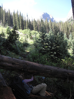
Ducking under logs heading to Vestal Basin
Ducking under logs on the way to Vestal Basin
At the east end of the beaver pond, leave Elk Creek trail and follow a strong climbers trail around a huge boulder on the east end of the pond. Follow this trail through a short wooded section with some good camping to a steep slope that drops down to Elk Creek. Crossing this creek in runoff seasons can be a bit treacherous depending on the presence/absence of a log bridge that is sometimes built here.

Cross the creek and start up what we dubbed "Hell Hill." The hill itself is only about 2 miles and gains just over 1,500 feet in elevation, but the trail is littered with downed trees and potential wrong turns. Stay high and stick to the main trail. Trying to stay closer to the creek will result only in rougher and steeper terrain you will have to negotiate.

At last you make it to the meadow at 11,500 feet in Vestal Basin. There are a couple of good campsites in the area, the best probably being on the left (east) side of the trail almost directly across from Wham itself. The mountains are beautiful and dramatic from this basin.

Climb up a steepening talus slope to the right of the obvious waterfall at the end of the meadow, and make your way to the bottom left corner of Wham Ridge (actually the peak's entire north face). Scramble up to a grassy ledge and do a rising traverse up and right to the face's west side just over 12,500 feet. So far the terrain shouldn't have exceeded class 3.

Scramble up the steepening face along its right side, roping up when and if you start feeling uncomfortable. There are a couple of decent splitter crack systems you can follow. The angle and difficulty steepen to low class 5 but just when it seems things are going to get really good, the rock becomes fractured and the climbing broken. Most people de-rope here and scramble the last few hundred feet on gunky class 4 to 5.easy to the summit.

Having fun with Wham
The Descent:
The descent is considered class 2+ but many people consider in class 3. It is long, loose and steep and not a great route to be on in a storm. From the summit descend southeast (not directly south, this leads to steep class 4 terrain) into a gully system on loose rock. Traverse when possible, following cairns for guidance, across the peak's south face, ultimately reaching the saddle between Vestal and Arrow Peaks. All that stand between you and the meadow is a gnarly downclimb down the slope Gerry Roach calls "Dues Collector" in his guidebook Colorado's Thirteeners: 13,800 to 13,999 feet. Back at the meadow you can relax (unless you have a train to catch) and be proud: you have just climbed one of Colorado's most aesthetic and classic mountaineering lines.

DIRECTIONS
The trailhead is found two miles north of Molas Pass on Highway 550 and five miles south of the town of Silverton. It is found in-between the turn offs for Molas and Little Molas Lake Campgrounds. The trailhead is a large dirt parking lot just off the highway on the canyon/mountain side.

TRIP REPORTS
Dirty (Wet) 30: or Five Rainy Days in the San Juans
Our attempt at Vestal and Arrow runs afoul of rain storms, bad navigation, and a general lack of time, but the trip was still one to remember.

LINKS
Mountainproject.com- Page on Wham Ridge standard route.

Summitpost.org- An information page on Wham Ridge (standard) route.


Visit THE ARCHIVE: A list of most of our articles sorted by department

find us on facebook

Follow us on Twitter!

Copyright notice: This website and all its contents are the intellectual property of www.coloradomountaineering.com and its authors. None of the content can be used or reproduced without the approval of www.coloradomountaineering.com.

Climbing and mountaineering are dangerous!! Please see the DISCLAIMER page
For information about how to contact us, visit this link


Monday, August 1, 2011

The Wild Gores


The Gore Range at Sunrise in the distance
The Gore Range at sunrise, seen from
the North Ridge route of Mount of the Holy Cross
A bear print, clear in the mud, the only sign of any life we'd seen, human or otherwise. All three of us looked at it in amazement; the length of the digits, the size of the perfectly imprinted claws. A bear had been through here, and recently.

I'd been told that the Gore Range is Colorado's most remote high alpine range. I'd been told that it was rugged and wild. That marmots attack viciously and the mountain ridges are impenetrable. That there are no trails, no people. What I found when I came to see the place for myself was that some of the Gore's wild reputation was exaggerated, but much of it was not.

Our first night we sat through a hellacious thunderstorm. Growling thunder was our constant companion for nearly three hours, tapering off at last to a forest of strange and frightening noises. When I fell asleep at last, my dreams were troubled by shapes on our tent walls and images of, strangely, people standing outside the tent.

With the popularity of 14er climbing in Colorado, any wilderness that surrounds one of those mountains is going to be busy, if not overrun, with backpackers and climbers. Though less popular, the so-called "Centennial" 13ers (the 47 highest thirteeners that join the 53 "official" 14ers to make up Colorado's 100 tallest list) also draw some attention. Mt. Powell, the Gore's highest peak at 13,580' is in a tie for #198. Many lists, as a result, rank it at #201. As a result, the Gores are mostly safe from the "peakbagging" crowds that populate other Colorado ranges.

On the other hand, The Gores are a legitimate mountaineering destination despite their modest height. The range is full of jagged ridges and impressive battlements. Many of the mountains are difficult and treacherous to climb, and some are very difficult to access. Several of the Gore's most prized mountains are nearly impossible to climb in a single day. Adding to the particular allure of the Gore Rang--in some strange way--is that most of the peaks don't have official names. For the adventurous mountaineer this adds to the mystique, giving the mountain a unexplored, uncharted feel.

Some of the more interesting mountains to climb in the Gores are accesssed most often from Slate Creek or one of the other nearby trailheads. Upper Slate Lake is a common base camp for many of the Gore Range classics such as so-called "Peak L" and "Peak Q", which follows the letter designation applied by CMC.

We survived the night, but one of our fellow backpackers had became ill, so we had to hike out. Foiled by the rugged Gores.

-Brian Wright

Visit THE ARCHIVE: A list of most of our articles sorted by department

find us on facebook


Copyright notice: This website and all its contents are the intellectual property of www.coloradomountaineering.com and its authors. None of the content can be used or reproduced without the approval of www.coloradomountaineering.com.

Climbing and mountaineering are dangerous!! Please see the DISCLAIMER page
For information about how to contact us, visit this link